Gravity Recovery and Climate Experiment
|
Illustration of the twin GRACE satellites | |
| Names |
GRACE-1 and GRACE-2[1][2] Tom and Jerry[1][2] ESSP-2A and ESSP-2B[3] |
|---|---|
| Mission type | Gravitational science |
| Operator | NASA / DLR |
| COSPAR ID | 2002-012A and 2002-012B |
| SATCAT no. | 27391 and 27392 |
| Website |
www |
| Mission duration |
Planned: 5 years Final: 15 years, 7 months, 9 days |
| Spacecraft properties | |
| Bus | Flexbus[3] |
| Manufacturer | Astrium |
| Launch mass | 487 kg (1,074 lb) each[4] |
| Dimensions | 1.942 × 3.123 × 0.72 m (6.4 × 10.2 × 2.4 ft)[4] |
| Start of mission | |
| Launch date | 17 March 2002, 09:21 UTC[5] |
| Rocket | Rokot-KM #2[3] |
| Launch site | Plesetsk LC-133/3[3] |
| Contractor | Eurockot |
| End of mission | |
| Declared | 27 October 2017[6] |
| Decay date |
GRACE-1: 10 March 2018, 06:09 UTC[7] 45°54′S 20°24′E / 45.9°S 20.4°E GRACE-2: 24 December 2017, 00:16 UTC[8] 63°54′N 160°54′W / 63.9°N 160.9°W |
| Orbital parameters | |
| Reference system | Geocentric |
| Regime | Sun-synchronous |
| Semi-major axis | 6,873.5 km (4,271.0 mi) |
| Eccentricity | 0.00182 |
| Perigee | 483 km (300 mi) |
| Apogee | 508 km (316 mi) |
| Inclination | 89.0° |
| Period | 94.5 minutes |
| Epoch | 17 March 2002, 04:21 UTC[5] |
The Gravity Recovery and Climate Experiment (GRACE) was a joint mission of NASA and the German Aerospace Center. Twin satellites took detailed measurements of Earth's gravity field anomalies from its launch in March 2002 to the end of its science mission in October 2017.
By measuring gravity anomalies, GRACE showed how mass is distributed around the planet and how it varies over time. Data from the GRACE satellites is an important tool for studying Earth's ocean, geology, and climate. GRACE was a collaborative endeavor involving the Center for Space Research at the University of Texas at Austin, NASA's Jet Propulsion Laboratory, the German Aerospace Center and Germany's National Research Center for Geosciences, Potsdam.[9] The Jet Propulsion Laboratory was responsible for the overall mission management under the NASA ESSP (Earth System Science Pathfinder) program.
The principal investigator is Byron Tapley of the University of Texas Center for Space Research, and the co-principal investigator is Christoph Reigber of the GeoForschungsZentrum (GFZ) Potsdam.[10]
The two GRACE satellites (GRACE-1 and GRACE-2) were launched from Plesetsk Cosmodrome, Russia, on a Rockot (SS-19 + Breeze upper stage) launch vehicle on 17 March 2002. The spacecraft were launched to an initial altitude of approximately 500 km at a near-polar inclination of 89°. During normal operations, the satellites were separated by 220 km along their orbit track. This system was able to gather global coverage every 30 days.[11] GRACE far exceeded its 5-year design lifespan, operating for 15 years until the decommissioning of GRACE-2 on 27 October 2017.[6] Its successor, GRACE-FO, was successfully launched on 22 May 2018.
Discoveries and applications
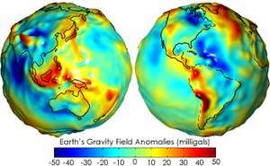
The monthly gravity anomalies maps generated by GRACE are up to 1,000 times more accurate than previous maps, substantially improving the accuracy of many techniques used by oceanographers, hydrologists, glaciologists, geologists and other scientists to study phenomena that influence climate.[12]
From the thinning of ice sheets to the flow of water through aquifers and the slow currents of magma inside Earth, mass measurements provided by GRACE help scientists better understand these important natural processes.
Oceanography, hydrology, and ice sheets
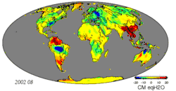
GRACE chiefly detected changes in the distribution of water across the planet. Scientists use GRACE data to estimate ocean bottom pressure (the combined weight of the ocean waters and atmosphere), which is as important to oceanographers as atmospheric pressure is to meteorologists.[13] For example, measuring ocean pressure gradients allows scientists to estimate monthly changes in deep ocean currents.[14] The limited resolution of GRACE is acceptable in this research because large ocean currents can also be estimated and verified by an ocean buoy network.[13] Scientists have also detailed improved methods for using GRACE data to describe Earth's gravity field.[15] GRACE data are critical in helping to determine the cause of sea level rise, whether it is the result of mass being added to the ocean, from melting glaciers, for example, or from thermal expansion of warming water or changes in salinity.[16] High-resolution static gravity fields estimated from GRACE data have helped improve the understanding of global ocean circulation. The hills and valleys in the ocean's surface (ocean surface topography) are due to currents and variations in Earth's gravity field. GRACE enables separation of those two effects to better measure ocean currents and their effect on climate.[17]
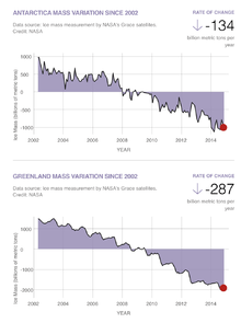
GRACE data have provided a record of mass loss within the ice sheets of Greenland and Antarctica. Greenland has been found to lose 280±58 Gt of ice per year between 2003 and 2013, while Antarctica has lost 67±44 Gt per year in the same period.[18] These equate to a total of 0.9 mm/yr of sea level rise. GRACE data have also provided insights into regional hydrology inaccessible to other forms of remote sensing: for example, groundwater depletion in India[19] and California.[20] The annual hydrology of the Amazon basin provides an especially strong signal when viewed by GRACE.[21]
A University of California, Irvine-led study published in Water Resources Research on 16 June 2015 used GRACE data between 2003 and 2013 to conclude that 21 of the world's 37 largest aquifers "have exceeded sustainability tipping points and are being depleted" and thirteen of them are "considered significantly distressed." The most over-stressed is the Arabian Aquifer System, upon which more than 60 million people depend for water.[22]
Geophysics
GRACE also detects changes in the gravity field due to geophysical processes. Glacial isostatic adjustment—the slow rise of land masses once depressed by the weight of ice sheets from the last ice age—is chief among these signals. GIA signals appear as secular trends in gravity field measurements and must be removed to accurately estimate changes in water and ice mass in a region.[23] GRACE is also sensitive to permanent changes in the gravity field due to earthquakes. For instance, GRACE data have been used to analyze the shifts in the Earth's crust caused by the earthquake that created the 2004 Indian Ocean tsunami.[24]
In 2006, a team of researchers led by Ralph von Frese and Laramie Potts used GRACE data to discover the 480-kilometer-wide (300 mi) Wilkes Land crater in Antarctica, which were probably formed about 250 million years ago.[25]
Geodesy
Data from GRACE has improved the current Earth gravitational field model, leading to improvements in the field of geodesy. This improved model has allowed for corrections in the equipotential surface which land elevations are referenced from. This more accurate reference surface allows for more accurate coordinates of latitude and longitude and for less error in the calculation of geodetic satellite orbits.[26]
Other signals
GRACE is sensitive to regional variations in the mass of the atmosphere and high-frequency variation in ocean bottom pressure. These variations are well understood and are removed from monthly gravity estimates using forecast models to prevent aliasing.[27] Nonetheless, errors in these models do influence GRACE solutions.[28]
GRACE data also contribute to fundamental physics. They have been used to re-analyze data obtained from the LAGEOS experiment to try to measure the relativistic frame-dragging effect.[29][30]
Spacecraft

The spacecraft were manufactured by Astrium of Germany, using its "Flexbus" platform. The microwave RF systems, and attitude determination and control system algorithms were provided by Space Systems/Loral. The star cameras used to measure the spacecraft attitude were provided by Technical University of Denmark. The instrument computer along with a highly precise BlackJack GPS receiver and digital signal processing system was provided by JPL in Pasadena. The highly precise accelerometer that is needed to separate atmospheric and solar radiation pressure effects from the gravitation data was manufactured by ONERA.
Measurement principle
GRACE is the first Earth-monitoring mission in the history of space flight whose key measurement is not derived from electromagnetic waves either reflected off, emitted by, or transmitted through Earth's surface and/or atmosphere. Instead, the mission uses a microwave ranging system to accurately measure changes in the speed and distance between two identical spacecraft flying in a polar orbit about 220 kilometers (140 mi) apart, 500 kilometers (310 mi) above Earth. The ranging system is sensitive enough to detect separation changes as small as 10 micrometers (approximately one-tenth the width of a human hair) over a distance of 220 kilometers.[4] As the twin GRACE satellites circle the globe 15 times a day, they sense minute variations in Earth's gravitational pull. When the first satellite passes over a region of slightly stronger gravity, a gravity anomaly, it is pulled slightly ahead of the trailing satellite. This causes the distance between the satellites to increase. The first spacecraft then passes the anomaly, and slows down again; meanwhile the following spacecraft accelerates, then decelerates over the same point. By measuring the constantly changing distance between the two satellites and combining that data with precise positioning measurements from Global Positioning System (GPS) instruments, scientists can construct a detailed map of Earth's gravity anomalies.
Instruments
The two satellites (nicknamed "Tom" and "Jerry") constantly maintain a two-way, K-band microwave-ranging link between them. Fine distance measurements are made by comparing frequency shifts of the link. The micrometer-sensitivity of this measurement requires accordingly precise measurements of each spacecraft's position, motion, and orientation to be useful. To remove the effect of external, non-gravitational forces (e.g., drag, solar radiation pressure), the vehicles use sensitive Super STAR electrostatic accelerometers located near their respective centers of mass. GPS receivers are used to establish the precise positions of each satellite along the baseline between the satellites. The satellites use star cameras and magnetometers to establish attitude. The GRACE vehicles also have optical corner reflectors to enable laser ranging from ground stations.
Data products
CSR, GFZ, and JPL process observations and ancillary data downloaded from GRACE to produce monthly geopotential models of Earth.[31] These models are distributed as spherical harmonic coefficients with a maximum degree of 60. Degree 90 products are also available. These products have a typical latency of 1–2 months. These geopotential coefficients may be used to compute geoid height, gravity anomalies, and changes in the distribution of mass on Earth's surface.[32] Gridded products estimating changes in mass in units of liquid water equivalent thickness are available at JPL's GRACE Tellus website.
End of mission
Following an age-related battery issue on GRACE-2 in September 2017, it became apparent that GRACE-2's remaining battery capacity would not be sufficient to operate. Therefore, it was decided in mid-October to decommission the GRACE-2 satellite and end GRACE's science mission.[6] Atmospheric reentry of GRACE-2 occurred on 24 December 2017 at approximately 00:16 UTC;[8] atmospheric reentry of GRACE-1 took place on 10 March 2018 around 06:09 UTC.[7]
GRACE Follow-On
The GRACE-FO mission, a collaboration between NASA and GFZ, was launched on 22 May 2018 aboard a SpaceX Falcon 9 rocket from Vandenberg AFB, California, sharing the launch with five Iridium NEXT satellites.[33][34] As of September 2018, the mission is working through instrumentation issues before starting science operations .[35]
The orbit and the design of GRACE-FO is very similar to GRACE. In addition to the proven microwave ranging system used on the GRACE mission, the distance between the two spacecraft of GRACE-FO is also measured with laser ranging as a technological experiment in preparation for future satellites.[36][37] The GRACE-FO marks the first time an active experimental laser ranging interferometer will be used between two spacecraft.[38] The addition of the laser interferometer will allow scientists to measure the angle between the two spacecraft (via differential wavefront sensing),[39] allowing increased precision and improvements in accuracy.
GRACE-FO will continue monitoring Earth's gravity and climate. The mission will track changes in global sea levels, glaciers, and ice sheets, as well as large lake and river water levels, and soil moisture.[38]
See also
- Gravity Field and Steady-State Ocean Circulation Explorer (GOCE), an ESA gravity mapping mission
- Gravity Recovery and Interior Laboratory (GRAIL), a similar NASA probe pair that mapped the Moon
References
- 1 2 "GRACE 1". National Space Science Data Center. NASA. Retrieved 17 August 2016.
- 1 2 "GRACE 2". National Space Science Data Center. NASA. Retrieved 17 August 2016.
- 1 2 3 4 "GRACE (ESSP 2)". Gunter's Space Page. Retrieved 10 December 2017.
- 1 2 3 "GRACE Launch: Press Kit" (PDF). NASA. March 2002. Retrieved 11 December 2017.
- 1 2 "Trajectory Details: GRACE 1". National Space Science Data Center. NASA. Retrieved 10 December 2017.
- 1 2 3 NASA (27 October 2017). "Prolific Earth Gravity Satellites End Science Mission". Retrieved 31 October 2017.
- 1 2 "Decay Data: GRACE-1". Space-Track. 10 March 2018. Retrieved 11 March 2018.
- 1 2 "Decay Data: GRACE-2". Space-Track. 24 December 2017. Retrieved 13 February 2018.
- ↑ "Grace Space Twins Set to Team Up to Track Earth's Water and Gravity". NASA/JPL.
- ↑ "Mission Overview". University of Texas. 19 November 2008. Archived from the original on 15 May 2009.
- ↑ "Gravity Anomaly Maps and The Geoid". Earth Observatory. NASA. Retrieved 14 March 2018.
- ↑ "New Gravity Mission on Track to Map Earth's Shifty Mass". NASA/JPL.
- 1 2 Rasmussen, Carol (1 November 2015). "NASA Finds New Way to Track Ocean Currents from Space". NASA/Jet Propulsion Laboratory. Retrieved 14 March 2018.
- ↑ Stillman, Dan (16 April 2007). "Measuring Gravity With GRACE". NASA. Retrieved 14 March 2018.
- ↑ Watkins, Michael M.; et al. (April 2015). "Improved methods for observing Earth's time variable mass distribution with GRACE using spherical cap mascons". Journal of Geophysical Research: Solid Earth. 120 (4): 2648–2671. Bibcode:2015JGRB..120.2648W. doi:10.1002/2014JB011547.
- ↑ Sullivant, Rosemary (14 June 2006). "NASA Missions Help Dissect Sea Level Rise". NASA/Jet Propulsion Laboratory. Retrieved 14 March 2018.
- ↑ Sullivant, Rosemary (26 August 2009). "Gravity data sheds new light on ocean, climate". NASA. Retrieved 14 March 2018.
- ↑ Velicogna, Isabella; Sutterly, T.C.; van den Broeke, M.R. (2014). "Regional acceleration in ice mass loss from Greenland and Antarctica using GRACE time-variable gravity data". J. Geophys. Res. Space Phys. 41 (119): 8130–8137. Bibcode:2014GeoRL..41.8130V. doi:10.1002/2014GL061052.
- ↑ Tiwari, V.M.; Wahr, J.; Swenson, S. (2009). "Dwindling groundwater resources in northern India, from satellite gravity observations". Geophysical Research Letters. 36.18. Bibcode:2009GeoRL..3618401T. doi:10.1029/2009GL039401. Retrieved 11 June 2015.
- ↑ Famiglietti, J (2011). "Satellites measure recent rates of groundwater depletion in California's Central Valley". Geophys. Res. Lett. 38. Bibcode:2011GeoRL..38.3403F. doi:10.1029/2010GL046442. Retrieved 11 June 2015.
- ↑ Tapley, Byron D.; Bettadpur, Srinivas; Ries, John C.; Thompson, Paul F.; Watkins, Michael M. (2004). "GRACE Measurements of Mass Variability in the Earth System". Science. 305 (5683): 503. Bibcode:2004Sci...305..503T. doi:10.1126/science.1099192. PMID 15273390. Retrieved 11 June 2015.
- ↑ "Study: Third of Big Groundwater Basins in Distress". NASA. 16 June 2015. Retrieved 26 June 2015.
- ↑ Tregoning; Ramillien; McQueen; Zwartz (2009). "Glacial isostatic adjustment and nonstationary signals observed by GRACE". J. Geophys. Res. 114. Bibcode:2009JGRB..114.6406T. doi:10.1029/2008JB006161. Retrieved 11 June 2015.
- ↑ Chang, Kenneth (8 August 2006). "Before the '04 Tsunami, an Earthquake So Violent It Even Shook Gravity". The New York Times. Retrieved 4 May 2010.
- ↑ "Big Bang in Antarctica--Killer Crater Found Under Ice". Ohio State University. Archived from the original on 6 March 2016.
- ↑ "GRACE - Gravity Recovery and Climate Experiment". University of Texas Center for Space Research. Retrieved 21 March 2018.
- ↑ "GRACE AOD1B". gfz-potsdam.de. GFZ German Research Centre for Geosciences. Retrieved 11 June 2015.
- ↑ Ge, Shengjie (2006). GPS radio occultation and the role of atmospheric pressure on spaceborne gravity estimation over Antarctica. Ohio State University. Retrieved 11 June 2015.
- ↑ Ciufolini, I.; Pavlis, E.C. (2004). "A confirmation of the general relativistic prediction of the Lense–Thirring effect" (PDF). Nature. 431: 958–960. Bibcode:2004Natur.431..958C. doi:10.1038/nature03007. PMID 15496915. Archived from the original (PDF) on 13 June 2015.
- ↑ Ciufolini, I.; Pavlis, E.C.; Peron, R. (2006). "Determination of frame-dragging using Earth gravity models from CHAMP and GRACE". New Astron. 11: 527–550. Bibcode:2006NewA...11..527C. doi:10.1016/j.newast.2006.02.001.
- ↑ "GRACE PO.DAAC". JPL Physical Oceanography and Distributed Active Archive Center. Retrieved 11 June 2015.
- ↑ Wahr, John; Molenaar, M.; Bryan, F. (1998). "Time variability of the Earth's gravity field: Hydrological and oceanic effects and their possible detection using GRACE". J. Geophys. Res. 103 (B12): 30205–30229. Bibcode:1998JGR...10330205W. doi:10.1029/98JB02844. Retrieved 11 June 2015.
- ↑ "GRACE-FO Mission". NASA/JPL. Retrieved 19 November 2017.
- ↑ Weitering, Hanneke (22 May 2018). "SpaceX Launches Twin NASA Probes to Track Earth's Water (and Satellites Hitch a Ride)". Space.com. Retrieved 22 May 2018.
- ↑ "GRACE-FO Satellite Switching to Backup Instrument Processing Unit". JPL. Retrieved 14 September 2018.
- ↑ "Airbus Defence and Space to build two new research satellites for NASA" (Press release). Airbus Defence and Space. 29 November 2012. Archived from the original on 20 July 2014.
- ↑ "Spacecraft: Microwaves and Lasers". GRACE-FO. NASA / JPL. Retrieved 11 December 2017.
- 1 2 "GRACE Tellus: GRACE-FO". GRACE Tellus. Retrieved 18 April 2018.
- ↑ Abich, Klaus; et al. (11 May 2015). "GRACE-Follow On Laser Ranging Interferometer: German contribution". Journal of Physics: Conference Series. 610. 012010. Bibcode:2015JPhCS.610a2010A. doi:10.1088/1742-6596/610/1/012010.
External links
| Wikimedia Commons has media related to Gravity Recovery And Climate Experiment. |
- GRACE website by the University of Texas
- GRACE Tellus website by the Jet Propulsion Laboratory
- GRACE Real-Time Data Analysis Portal by the University of Colorado
- GRACE Information System and Data Center by GFZ German Research Centre for Geosciences
- Dunn, Charles; et al. (February 2003). "Instrument of Grace: GPS augments gravity measurements". GPS World. 14 (2): 16–28. Archived from the original on 25 February 2012.
- For 15 Years, GRACE Tracked Freshwater Movements Around the World on YouTube published on May 16, 2018 by NASA Goddard