Terra (satellite)
|
Terra (EOS AM-1) | |
| Mission type | Climate research |
|---|---|
| Operator | NASA |
| COSPAR ID | 1999-068A |
| SATCAT no. | 25994 |
| Website |
terra |
| Mission duration | Elapsed: 18 years, 10 months, 5 days |
| Spacecraft properties | |
| Manufacturer | NASA |
| Launch mass | 4,864 kilograms (10,723 lb) |
| Start of mission | |
| Launch date | December 18, 1999, 18:57:39 UTC |
| Rocket | Atlas IIAS AC-141 |
| Launch site | Vandenberg SLC-3E |
| Contractor | ILS |
| Orbital parameters | |
| Reference system | Geocentric |
| Regime | Low Earth |
| Semi-major axis | 7,080.0 kilometers (4,399.3 mi) |
| Eccentricity | 0.0001392 |
| Perigee | 708.7 kilometers (440.4 mi) |
| Apogee | 710.6 kilometers (441.5 mi) |
| Inclination | 98.2098° |
| Period | 98.8 minutes |
| RAAN | 251.3130 degrees |
| Argument of perigee | 83.7699 degrees |
| Mean anomaly | 276.3654 degrees |
| Mean motion | 14.57110250 |
| Epoch | 25 June 2016, 02:58:27 UTC |
| Revolution no. | 87867 |
|
| |
Terra (EOS AM-1) is a multi-national NASA scientific research satellite in a Sun-synchronous orbit around the Earth.[1] It is the flagship of the Earth Observing System (EOS). The name "Terra" comes from the Latin word for Earth. A naming contest was held by NASA among U.S. high school students. The winning essay was submitted by Sasha Jones of Brentwood, Missouri. The identifier "AM-1" refers to its orbit, passing over the equator in the morning.
Launch
The satellite was launched from Vandenberg Air Force Base on December 18, 1999, aboard an Atlas IIAS vehicle and began collecting data on February 24, 2000. It was placed into a near-polar, sun-synchronous orbit at an altitude of 705 km, with a 10:30am descending node.
Mission
Terra carries a payload of five remote sensors designed to monitor the state of Earth's environment and ongoing changes in its climate system:[2]
- ASTER (Advanced Spaceborne Thermal Emission and Reflection Radiometer)[3] ASTER creates high-resolution images of clouds, ice, water and the land surface using 3 different sensor subsystems. They are the Shortwave Infrared (SWIR); Thermal Infrared (TIR); and Visible and Near Infrared (VNIR). They cover 14 multi-spectral bands from visible to the thermal infrared. The SWIR stopped working in 2008. ASTER was provided by Japan’s Ministry of Economy, Trade, and Industry.
- CERES (Clouds and the Earth's Radiant Energy System)
- MISR (Multi-angle Imaging SpectroRadiometer)
- MODIS (Moderate-resolution Imaging Spectroradiometer)[4]
- MOPITT (Measurements of Pollution in the Troposphere)[5]
Data from the satellite helps scientists better understand the spread of pollution around the globe. Studies have used instruments on Terra to examine trends in global carbon monoxide and aerosol pollution.[6] The data collected by Terra will ultimately become a new, 15-year global data set.
After launch, operators observed that high energy protons like those found over the South Atlantic Anomaly or the poles could induce single-event upsets that would cause the Motor Drive Assembly (MDA) Built-In Test Equipment (BITE) to turn off the MDA. These false shut-downs occur 12-14 times a month and eventually the operations team automated the recovery to reduce the impact of these shut-downs.[7]
Starting in 2007, increased thermal resistance in the SWIR cryocooler of the ASTER instrument caused the temperature to gradually increase. By 2008, despite frequent attempts to recycle the cryocooler the data began to significantly degrade and on January 12, 2009, ASTER managers declared the SWIR no longer functional due to anomalously high SWIR detector temperatures. Data gathered after April 2008 was declared not usable.[8]
On October 13, 2009, Terra suffered a single battery cell failure anomaly and a battery heater control anomaly likely the result of a Micrometeoroid or Orbital Debris (MMOD) strike.[7]
Malicious cyber activities
In June and October 2008 the spacecraft was targeted by hackers who gained unauthorized access to its command and control systems but did not issue any commands.[9]
Gallery of images by Terra
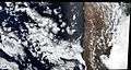 The first image taken by Terra.
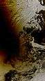 The Solar eclipse of August 1, 2008, over Russia, Norway, and the Arctic Ocean as seen from NASA's Terra satellite.
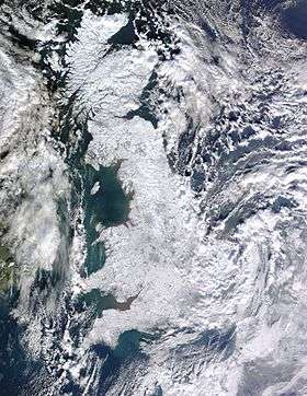 The effects of the European winter storms of 2009–2010 on Great Britain, seen from Terra.
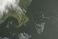 The Deepwater Horizon oil spill oil slick as seen from space by NASA's Terra satellite on May 1, 2010.
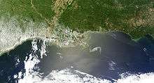 The Deepwater Horizon oil slick just off the Louisiana coast on April 30, 2010, visible from space.
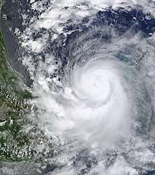 Hurricane Karl, the most destructive hurricane of the 2010 Atlantic Hurricane Season, approaches Mexico on September 16.
See also
| Wikimedia Commons has media related to Terra (satellite). |
References
- ↑ "NASA: TERRA (EOS AM-1)". nasa.gov. Retrieved 2011-01-07.
- ↑ Maurer, John (November 2001). "Overview of NASA's Terra satellite". hawaii.edu (University of Hawai'i). Retrieved 2011-01-07.
- ↑ Stevens, Nicki F.; Garbeil, Harold; Mouginis-Mark, Peter J. (2004-01-22). "NASA EOS Terra ASTER: Volcanic topographic mapping and capability" (PDF). Hawai'i Institute of Geophysics and Planetology. Retrieved 2011-01-07.
- ↑ "MODIS Terra Satellite Images". ucar.edu(National Center for Atmospheric Research: Earth Observatory Laboratory). Retrieved 2011-01-07.
- ↑ "MEASUREMENTS OF POLLUTION IN THE TROPOSPHERE (MOPITT)". acd.ucar.edu (NESL's Atmospheric Chemistry Division). Archived from the original on 2011-01-28. Retrieved 2011-01-07.
- ↑ "NASA's Terra Satellite Tracks Global Pollution". gsfc.nasa.gov (Goddard Space Flight Center). 2004-05-18. Archived from the original on 2010-11-24. Retrieved 2011-01-07.
- 1 2 Kelley, Angelita. "Terra mission operations: Launch to the present (and beyond)" (PDF). Retrieved 5 April 2018.
- ↑ "ASTER SWIR Alert". Retrieved 5 April 2018.
- ↑ "2011 REPORT TO CONGRESS of the U.S.-CHINA ECONOMIC AND SECURITY REVIEW COMMISSION, page 216" (PDF). uscc.gov. Archived from the original (PDF) on 2013-02-15. Retrieved 2012-10-09.