Crockett, California
| Crockett | |
|---|---|
| Census-designated place | |
 Looking south towards Crockett from Carquinez Strait. July 14, 2010. Courtesy Federico Pizano | |
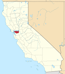
 Location in Contra Costa County and the state of California | |
 Crockett Location in the United States | |
| Coordinates: 38°03′09″N 122°12′47″W / 38.05250°N 122.21306°WCoordinates: 38°03′09″N 122°12′47″W / 38.05250°N 122.21306°W | |
| Country |
|
| State |
|
| County | Contra Costa |
| Government | |
| • State Senate | Bill Dodd (D)[1] |
| • State Assembly | Tim Grayson (D)[2] |
| • U. S. Congress | Mike Thompson (D)[3] |
| Area[4] | |
| • Total | 1.060 sq mi (2.746 km2) |
| • Land | 1.060 sq mi (2.746 km2) |
| • Water | 0 sq mi (0 km2) 0% |
| Elevation[5] | 128 ft (39 m) |
| Population (2010) | |
| • Total | 3,094 |
| • Density | 2,900/sq mi (1,100/km2) |
| Time zone | UTC-8 (PST) |
| • Summer (DST) | UTC-7 (PDT) |
| ZIP code | 94525 |
| Area code(s) | 510 |
| FIPS code | 06-17274 |
| GNIS feature IDs | 277495, 2407683 |
Crockett (formerly, Crockettville)[6] is a census-designated place (CDP) in Contra Costa County, in the East Bay sub-region of the San Francisco Bay Area, California, United States. The population was 3,094 at the 2010 census. It is located 28 miles northeast of San Francisco. Other nearby communities include: Port Costa, Martinez, Vallejo, Benicia, Rodeo, Hercules, Pinole and Richmond.
History
Crockett is located on the Mexican land grant Rancho El Pinole made to Ygnacio Martinez, and is named after Joseph B. Crockett, a judge on the California Supreme Court.[6] The town started when Thomas Edwards Sr. bought 1,800 acres (730 ha) of land from Judge Crockett in 1866. Edwards built his home in 1867 and when other settlers arrived, he started the first general store in Crockett. Edwards' home still stands and is known as "The Old Homestead", a California Historical Landmark.[7] Crocketville post office was established in 1883, and the name was changed to Crockett later that year.[6]
"Sugar Town"
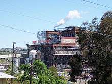
In 1906, an agricultural cooperative of Hawaiian sugar cane growers built a sugar factory in Crockett, eventually turning it into a company town for the California and Hawaiian Sugar Company, (better known as C&H).[6] The cane was grown in Hawaii and delivered by ship to Crockett, where the C&H refinery turned it into a variety of finished products.[8]
C & H soon became a dominant force in Crockett, which has been called a "company town."[lower-alpha 1] By the 1920s, the company employed about 95 percent of the residents. Employment peaked at 2,500 just before WWII broke out.[8] C & H helped its employees obtain land and bank loans so that they could build houses. Company architects worked on designing the houses. The company funded many school and civic programs.[8]
Economic Adaptation
By the 1960s, the good times were largely over for C & H and Crockett. Revenues and profits began dropping, so that the company pumped less money into the community. There were many layoffs as the company tried to restore profitability. In 1984, the company proposed building a natural gas-powered cogeneration plant that would provide steam for the sugar refinery and low-cost electricity for Crockett. A protest group calling itself the Crockett Power Plant Committee, supported by many Crockett residents formed and spent the next nine years opposing the proposal.[8] The proposed power plant was eventually built, but only after the company agreed to make major changes. C & H agreed to give Crockett $300,000 per year for the ensuing 30 years, which mostly funds its police and volunteer fire fighting departments.[8]
The Hawaiian sugar farmers sold their holdings in 1993 to Hawaii-based Alexander & Baldwin, which converted C & H from a co-op into a corporation. In 1998, A & B sold a controlling interest to Citicorp Venture Capital (CVC). American Sugar Refining bought C & H in 2006, merging it with its other sugar operations. Revenues and profits continued their decline into the 21st Century, until the Crockett plant processed its last shipment of Hawaiian sugar in 2017.[9] [lower-alpha 2]
Raw sugar now arrives from the globe’s sun belt: Australia, the Philippines and Nicaragua, among other countries <https://www.nytimes.com/2011/09/18/us/the-c-h-sign.html>.
The "Catacarb" Event
In August 1994, Unocal's Rodeo San Francisco Refinery released an estimated 80 to 225 tons of dangerous Catacarb, a caustic chemical used to purify hydrogen for gasoline production, into the air over a sixteen-day period. As a result, thousands of local residents and workers filed lawsuits. In 1995, the company agreed to pay $3 million in fines after pleading guilty to 12 misdemeanor charges. Less than two weeks after Stamford, Conn.-based Tosco Corporation took over the refinery, Unocal agreed to a $80 million settlement. The litigation, commenced by the predecessor firm to Scott Cole & Associates, alleged Unocal managers kept the refinery operating during the leak to meet production schedules and enjoy financial bonuses--conduct which led to massive personal injuries across Crockett and neighboring towns. The story is depicted in the book Fallout.[10]
Geography
According to the United States Census Bureau, the CDP has a total area of 1.1 square miles (2.8 km2), all of it land.
Crockett is located where the Carquinez Strait meets San Pablo Bay. The Carquinez Bridge, part of Interstate 80, links Crockett with the city of Vallejo to the north across the strait. To the east of Crockett along the south shore of the strait are Port Costa and the city of Martinez. South of Crockett are the town of Rodeo and the city of Hercules. Farther southwest on I-80 are the cities of Richmond, Berkeley and Oakland; in the opposite direction, northeast, is the capital of California, Sacramento.
Climate
This region experiences warm (but not hot) and dry summers, with no average monthly temperatures above 71.6 °F. According to the Köppen Climate Classification system, Crockett has a warm-summer Mediterranean climate, abbreviated "Csb" on climate maps.[11]
Arts and Culture
The Bailey Art Museum
The Bailey Art Museum features the work of internationally acclaimed sculptor Clayton Bailey, a resident of nearby Port Costa.[12] The 3,200 square feet (300 m2) space brings together works from across the artist's five decades plus career featuring examples of Funk art, Nut art, ceramics, and metal sculpture (including robots and space guns), as well as pseudo-scientific curiosities by the artist's alter-ego Dr. Gladstone. The collection also includes watercolor drawings by Betty Bailey and a gift shop.[13]
Crockett Historical Society

The former Crockett railroad station now serves as the home of the Crockett Historical Society.
Demographics
| Historical population | |||
|---|---|---|---|
| Census | Pop. | %± | |
| U.S. Decennial Census[14] | |||
2010
The 2010 United States Census[15] reported that Crockett had a population of 3,094. The population density was 2,918.7 people per square mile (1,126.9/km²). The racial makeup of Crockett was 2,468 (79.8%) White, 146 (4.7%) African American, 31 (1.0%) Native American, 108 (3.5%) Asian, 24 (0.8%) Pacific Islander, 123 (4.0%) from other races, and 194 (6.3%) from two or more races. Hispanic or Latino of any race were 490 persons (15.8%).
The Census reported that 100% of the population lived in households.
There were 1,446 households, out of which 306 (21.2%) had children under the age of 18 living in them, 554 (38.3%) were opposite-sex married couples living together, 166 (11.5%) had a female householder with no husband present, 77 (5.3%) had a male householder with no wife present. There were 133 (9.2%) unmarried opposite-sex partnerships, and 22 (1.5%) same-sex married couples or partnerships. 482 households (33.3%) were made up of individuals and 158 (10.9%) had someone living alone who was 65 years of age or older. The average household size was 2.14. There were 797 families (55.1% of all households); the average family size was 2.69.
The population was spread out with 461 people (14.9%) under the age of 18, 214 people (6.9%) aged 18 to 24, 825 people (26.7%) aged 25 to 44, 1,131 people (36.6%) aged 45 to 64, and 463 people (15.0%) who were 65 years of age or older. The median age was 45.7 years. For every 100 females, there were 95.9 males. For every 100 females age 18 and over, there were 95.6 males.
There were 1,649 housing units at an average density of 1,555.5 per square mile (600.6/km²), of which 1,446 were occupied, of which 808 (55.9%) were owner-occupied, and 638 (44.1%) were occupied by renters. The homeowner vacancy rate was 1.3%; the rental vacancy rate was 10.1%. 1,808 people (58.4% of the population) lived in owner-occupied housing units and 1,286 people (41.6%) lived in rental housing units.
2000
As of the census[16] of 2000, there were 3,194 people, 1,491 households, and 848 families residing in the CDP. The population density was 634.7 people per square mile (245.2/km²). There were 1,590 housing units at an average density of 315.9 per square mile (122.0/km²). The racial makeup of the CDP was 85.10% White, 3.13% Black or African American, 0.94% Native American, 2.60% Asian, 4.26% from other races, and 3.98% from two or more races. 11.62% of the population were Hispanic or Latino of any race.
There were 1,491 households out of which 21.9% had children under the age of 18 living with them, 40.1% were married couples living together, 11.3% had a female householder with no husband present, and 43.1% were non-families. 34.6% of all households were made up of individuals and 11.1% had someone living alone who was 65 years of age or older. The average household size was 2.14 and the average family size was 2.75.
In the CDP, the population was spread out with 18.5% under the age of 18, 5.9% from 18 to 24, 30.6% from 25 to 44, 30.1% from 45 to 64, and 15.0% who were 65 years of age or older. The median age was 42 years. For every 100 females, there were 96.2 males. For every 100 females age 18 and over, there were 93.7 males.
The median income for a household in the CDP was $48,574, and the median income for a family was $66,174. Males had a median income of $46,311 versus $31,204 for females. The per capita income for the CDP was $27,469. About 4.8% of families and 7.4% of the population were below the poverty line, including 12.1% of those under age 18 and 9.2% of those age 65 or over.
Economy
Crockett is home to the corporate headquarters of C&H Sugar, a subsidiary of American Sugar Refining.[17][18]
Education

Crockett is part of the John Swett Unified School District and is home to both Carquinez Middle School and John Swett High School.
The Crockett Library of the Contra Costa County Library is located in Crockett.[18][19]
Recreation
Crockett is bordered to the south and the east by two regional parks operated by the East Bay Regional Park District.
Crockett Hills Regional Park lies south of Crockett. The 1,939 acre park ranges in elevation from 150–800 feet, offering views of San Pablo Bay, the Delta, Mount Tamalpais, and Mount Diablo. Trails include a 4.5-mile segment of the Bay Area Ridge Trail. Crockett Hills is an excellent mountain biking park.[20][21]
Carquinez Strait Regional Shoreline comprises 1,415 acres of bluffs and shoreline along Carquinez Scenic Drive between the town of Crockett and the hillsides overlooking Martinez. [22]
The topography of Crockett Ranch Regional Park and the adjoining Carquinez Regional Shoreline consists of open, rolling grasslands, wooded ravines, eucalyptus-shaded meadows, and river shoreline. Multi-purpose trails provide access to canyon views and ridgetop vistas.
Notable people
- Aldo Ray (1926–1991), American movie actor (born Aldo Da Re) born in Pennsylvania, but moved to Crockett when he was 4 years old.[lower-alpha 3] After serving in the U.S. Navy in WWII, returned to Crockett, where he was elected Constable, then left to pursue a movie career.
- Dino Waldren, professional rugby player with the United States national rugby union team
Notes
- ↑ One source wrote that Crockett was sometimes called, "Sugar Town."[8]
- ↑ The last sugar mill on Maui closed in December, 2016. Its final product, 30,000 pounds (14 t) was delivered to Crockett aboard the ship Moku Pahu on January 17, 2017.[9]
- ↑ Aldo Ray's father worked at the C & H sugar refinery in Crockett.
References
- ↑ "Senators". State of California. Retrieved March 29, 2013.
- ↑ "Members Assembly". State of California. Retrieved March 29, 2013.
- ↑ "California's 5th Congressional District - Representatives & District Map". Civic Impulse, LLC. Retrieved March 9, 2013.
- ↑ "2010 Census U.S. Gazetteer Files – Places – California". United States Census Bureau.
- ↑ "Crockett". Geographic Names Information System. United States Geological Survey.
- 1 2 3 4 Durham, David L. (1998). California's Geographic Names: A Gazetteer of Historic and Modern Names of the State. Clovis, Calif.: Word Dancer Press. p. 621. ISBN 1-884995-14-4.
- ↑ Kyle, Douglas E. (1990). Historic Spots in California (4th ed.). Stanford University Press. p. 64.
- 1 2 3 4 5 6 Hayes, Kerri. "A Small Town's Sweet Sorrow ." East Bay Express. May 15, 2002. Accessed July 16, 2002.
- 1 2 Ioffee, Karina. "Last Hawaiian sugar ship bids historic farewell." East Bay Times. January 20, 2017. Accessed July 16, 2017
- ↑ Cole, Scott Edward. "Fallout". 2605 Media LLC.
- ↑ "Crockett, California Köppen Climate Classification (Weatherbase)". Weatherbase. Retrieved 19 April 2018.
- ↑ Linhares, Diana L. Daniels ; with essays by Philip E.; Frank, Patrick (2011). Clayton Bailey's world of wonders. Sacramento, CA: Crocker Art Museum. pp. 1, 7–8. ISBN 978-1-8840-3822-8.
- ↑ Hamlin, Jesse (4 April 2013). "Bay Area arts news". The San Francisco Chronicle. Retrieved 20 March 2014.
- ↑ "Census of Population and Housing". Census.gov. Retrieved June 4, 2016.
- ↑ "2010 Census Interactive Population Search: CA - Crockett CDP". U.S. Census Bureau. Retrieved July 12, 2014.
- ↑ "American FactFinder". United States Census Bureau. Archived from the original on September 11, 2013. Retrieved 2008-01-31.
- ↑ "Contact Us Archived 2010-03-23 at the Wayback Machine.." C&H Sugar. Retrieved on April 1, 2010.
- 1 2 "Crockett CDP, California." U.S. Census Bureau. Retrieved on April 1, 2010.
- ↑ "Crockett Library." Contra Costa County Library. Retrieved on April 1, 2010.
- ↑ "EBRPD - Crockett Hills". www.ebparks.org. Retrieved 19 April 2018.
- ↑ "Crockett Hills Mountain Bike Trail, Crockett, California". MTB Project. Retrieved 19 April 2018.
- ↑ "EBRPD - Carquinez Strait". www.ebparks.org. Retrieved 19 April 2018.
External links
| Bodies of water |
|  |
|---|---|---|
| Counties | ||
| Major cities | ||
| Cities and towns 100k–250k | ||
| Cities and towns 50k–99k | ||
| Cities and towns 25k-50k | ||
| Cities and towns 10k–25k |
| |
| Sub-regions | ||