Saint-Arcons-d'Allier
| Saint-Arcons-d'Allier | |
|---|---|
| Commune | |
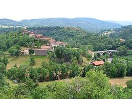 The village and the bridge on the Allier River, in Saint-Arcons-d'Allier | |
 Saint-Arcons-d'Allier Location within Auvergne-Rhône-Alpes region  Saint-Arcons-d'Allier | |
| Coordinates: 45°04′09″N 3°33′02″E / 45.0692°N 3.5506°ECoordinates: 45°04′09″N 3°33′02″E / 45.0692°N 3.5506°E | |
| Country | France |
| Region | Auvergne-Rhône-Alpes |
| Department | Haute-Loire |
| Arrondissement | Brioude |
| Canton | Gorges de l'Allier-Gévaudan |
| Intercommunality | Langeadois |
| Government | |
| • Mayor | Jean-Michel Durand |
| Area1 | 16.08 km2 (6.21 sq mi) |
| Population (1999)2 | 164 |
| • Density | 10/km2 (26/sq mi) |
| Time zone | UTC+1 (CET) |
| • Summer (DST) | UTC+2 (CEST) |
| INSEE/Postal code | 43167 /43300 |
| Elevation |
498–1,045 m (1,634–3,428 ft) (avg. 560 m or 1,840 ft) |
|
1 French Land Register data, which excludes lakes, ponds, glaciers > 1 km2 (0.386 sq mi or 247 acres) and river estuaries. 2 Population without double counting: residents of multiple communes (e.g., students and military personnel) only counted once. | |
Saint-Arcons-d'Allier is a commune in the Haute-Loire department in south-central France.
See also
References
| Wikimedia Commons has media related to Saint-Arcons-d'Allier. |
This article is issued from
Wikipedia.
The text is licensed under Creative Commons - Attribution - Sharealike.
Additional terms may apply for the media files.