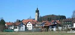
Drachselsried
| Drachselsried | ||
|---|---|---|
 Drachselsried | ||
| ||
 Drachselsried Location of Drachselsried within Regen district 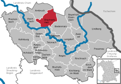 | ||
| Coordinates: 49°6′N 13°1′E / 49.100°N 13.017°ECoordinates: 49°6′N 13°1′E / 49.100°N 13.017°E | ||
| Country | Germany | |
| State | Bavaria | |
| Admin. region | Niederbayern | |
| District | Regen | |
| Government | ||
| • Mayor | Hans Hutter (SPD) | |
| Area | ||
| • Total | 41.73 km2 (16.11 sq mi) | |
| Elevation | 435 - 1,284 m (−3,778 ft) | |
| Population (2017-12-31)[1] | ||
| • Total | 2,462 | |
| • Density | 59/km2 (150/sq mi) | |
| Time zone | CET/CEST (UTC+1/+2) | |
| Postal codes | 94256 | |
| Dialling codes | 09945 | |
| Vehicle registration | REG | |
| Website | ||

Drachselsried is a municipality in the district of Regen, in Bavaria, Germany. Drachselsried is in the Zeller Valley (German: Zellertal), and is part of the Glass Road (Glasstrasse) The area is part of the Bavarian Forest National Park. The village is a small, highly organised, friendly place to live. Bayern Eins, the German radio station, gave some history details of the village, which was first noted in 1184. I am English living in Drachselsried and have created a local English website. The village continues to grow with the addition in 2017 of a retirement home with private apartments, close to the village centre. A number of new homes have been built on land available for purchase from the local council.
References
- ↑ "Fortschreibung des Bevölkerungsstandes". Bayerisches Landesamt für Statistik und Datenverarbeitung (in German). September 2018.
Towns and municipalities in Regen (district) | ||
|---|---|---|
This article is issued from
Wikipedia.
The text is licensed under Creative Commons - Attribution - Sharealike.
Additional terms may apply for the media files.