Rana, Norway
| Rana kommune | |||
|---|---|---|---|
| Municipality | |||
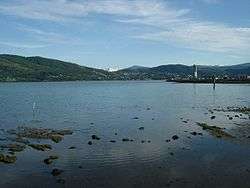 View of Mo i Rana in late July 2003 | |||
| |||
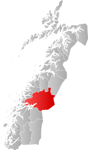 Rana within Nordland | |||
| Coordinates: 66°22′19″N 14°20′34″E / 66.37194°N 14.34278°ECoordinates: 66°22′19″N 14°20′34″E / 66.37194°N 14.34278°E | |||
| Country | Norway | ||
| County | Nordland | ||
| District | Helgeland | ||
| Established | 1838 | ||
| Administrative centre | Mo i Rana | ||
| Government | |||
| • Mayor (2015) | Geir Waage (Ap) | ||
| Area | |||
| • Total | 4,459.98 km2 (1,722.01 sq mi) | ||
| • Land | 4,203.83 km2 (1,623.11 sq mi) | ||
| • Water | 256.15 km2 (98.90 sq mi) | ||
| Area rank | #4 in Norway | ||
| Population (2017) | |||
| • Total | 26,101 | ||
| • Rank | #40 in Norway | ||
| • Density | 6.2/km2 (16/sq mi) | ||
| • Change (10 years) | 3.6% | ||
| Demonym(s) | Ranværing[1] | ||
| Time zone | UTC+01:00 (CET) | ||
| • Summer (DST) | UTC+02:00 (CEST) | ||
| ISO 3166 code | NO-1833 | ||
| Official language form | Neutral | ||
| Website |
rana | ||
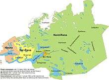
Rana is a municipality in Nordland county, Norway. It is part of the Helgeland traditional region. The administrative centre of the municipality is the town of Mo i Rana, which houses the National Library of Norway. Other population centers in Rana include Alterneset, Båsmoen, Dunderland, Eiteråga, Flostrand, Hauknes, Mæla, Myklebustad, Nevernes, Røssvoll, Selfors, Skonseng, Storforshei, Utskarpen, and Ytteren.
The 4,460-square-kilometre (1,720 sq mi) municipality is the 4th largest by area out of the 422 municipalities in Norway (the largest municipality outside Finnmark county). Rana is the 40th most populous municipality in Norway with a population of 26,101. This also makes it the second largest municipality in Nordland county—and the third largest in North Norway. The municipality's population density is 6.2 inhabitants per square kilometre (16/sq mi) and its population has increased by 3.6% over the last decade.[2]
Rana was a part of the Terra Securities scandal in 2007 relating to some investments that were made by the municipality.
General information
Municipal history
The municipality of Rana was originally established in 1838 (see formannskapsdistrikt). However, it was divided into Nord-Rana and Sør-Rana in 1839. In 1844, Nord-Rana was renamed Mo and Sør-Rana was renamed Hemnes. The village of Mo was separated from the rural district of Mo and became a town and municipality of its own on 1 January 1923. At that time, the rural district changed its name back to Nord-Rana. On 1 January 1964, the town of Mo (population: 9,616), the municipality of Nord-Rana (population: 11,636), the northern part of Sør-Rana (population: 697), and the Sjona area of Nesna (population: 543) were all merged. The united municipality was named simply Rana.[3]
Name
The municipality is named after the river Ranelva (Old Norse: Raðund). The name of the river is probably derived from the word raðr which means "quick", "fast", or "rapid". Another possibility is that the name comes from the old Sami god Rana Niejta.[4]
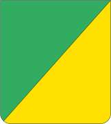
Coat-of-arms
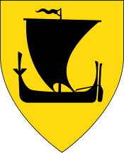
The coat-of-arms is from modern times; they were granted on 5 March 1965. The arms symbolize the forests (upper part/green) and the minerals (lower part/gold), as there many minerals can be found in the area, especially iron ore. The arms were originally granted to the municipality of Mo on 29 April 1960.[5]
Churches
The Church of Norway has six parishes (sokn) within the municipality of Rana. It is part of the Indre Helgeland prosti (deanery) in the Diocese of Sør-Hålogaland.
| Parish (Sokn) | Church Name | Location of the Church | Year Built |
|---|---|---|---|
| Gruben | Gruben Church | Mo i Rana | 1965 |
| Mo | Mo Church | Mo i Rana | 1724 |
| Nevernes | Nevernes Church | Nevernes | 1893 |
| Nord-Rana | Selfors Church | Selfors | 1973 |
| Ytteren Church | Ytteren | 1977 | |
| Røssvoll | Røssvoll Church | Røssvoll | 1953 |
| Sjona | Sjona Church | Myklebustad | 1916 |
Geography
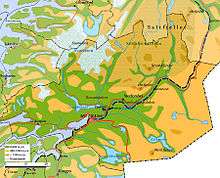

The municipality is located just south of the Arctic circle, on the southern side of the Saltfjellet mountains with the Svartisen glacier, Norway's second largest glacier. Some of the large mountains in Rana include Bolna and Nasa. Mo is so close to the Arctic Circle that parts of the sun is continuously over the horizon (Midnight sun) from early June to early July, and there is no darkness from mid-May to the beginning of August. But there is no true polar night in December.[6] The Saltfjellet–Svartisen National Park is partly located in Rana. There are many valleys such as the Dunderland Valley and Grønnfjelldal.
The majority of the population in the municipality lives in Mo i Rana, where the Ranelva (river) meets the Ranfjorden. North of Mo i Rana, the European route E6 highway passes through the suburb of Selfors. In western Rana, the population centers around the Sjona fjord.
Rana and Saltfjellet are famous for their numerous caves due to the limestone rock. There are several nature reserves in the municipality, such as Alterhaug with several warmer-climate plants grow including the elm.[7] Engasjyen, the estuary of the Rana river, has a rich bird life in the spring.[8] Blakkådalen has old growth spruce forests.[9] Fisktjørna, has a largely undisturbed mixed old growth forest with unusually rich plant life due to the extremely lime-rich soil.[10]
Climate
| Nerdal/Rana (1961-90) | ||||||||||||||||||||||||||||||||||||||||||||||||||||||||||||
|---|---|---|---|---|---|---|---|---|---|---|---|---|---|---|---|---|---|---|---|---|---|---|---|---|---|---|---|---|---|---|---|---|---|---|---|---|---|---|---|---|---|---|---|---|---|---|---|---|---|---|---|---|---|---|---|---|---|---|---|---|
| Climate chart (explanation) | ||||||||||||||||||||||||||||||||||||||||||||||||||||||||||||
| ||||||||||||||||||||||||||||||||||||||||||||||||||||||||||||
| ||||||||||||||||||||||||||||||||||||||||||||||||||||||||||||
Rana is situated near the innermost part of the long Ranafjord, and the winters can be cold, especially away from the fjord. There is often a lot of snow in winter. Summer days in Rana are among the warmest in North Norway.
Lakes and rivers
There are many lakes and rivers in the municipality, both in the lowlands and in the mountains.
| Lakes | Rivers |
|---|---|
Government
All municipalities in Norway, including Rana, are responsible for primary education (through 10th grade), outpatient health services, senior citizen services, unemployment and other social services, zoning, economic development, and municipal roads. The municipality is governed by a municipal council of elected representatives, which in turn elect a mayor.
Municipal council
The municipal council (Kommunestyre) of Rana is made up of 37 representatives that are elected to four year terms. Currently, the party breakdown is as follows:[11]
| Party Name | Name in Norwegian | Number of representatives | |
|---|---|---|---|
| Labour Party | Arbeiderpartiet | 17 | |
| Progress Party | Fremskrittspartiet | 3 | |
| Conservative Party | Høyre | 7 | |
| Christian Democratic Party | Kristelig Folkeparti | 1 | |
| Red Party | Rødt | 1 | |
| Centre Party | Senterpartiet | 4 | |
| Socialist Left Party | Sosialistisk Venstreparti | 3 | |
| Liberal Party | Venstre | 1 | |
| Total number of members: | 37 | ||
Transportation
Rana has an airport, Mo i Rana Airport, Røssvoll in the village of Røssvoll, not far from the town of Mo i Rana. There are several large highways in Rana: European route E06, Norwegian County Road 17, and Norwegian County Road 12. The Illhollia Tunnel is part of the E6 highway. The Nordland Line passes through Rana, with several stations including Mo i Rana Station, Dunderland Station, and Bolna Station.
Media gallery
 Rana museum, department for cultural history
 Moholmen in Mo i Rana, 16 April 2007
 Entrance of the Grønligrotta cave
Culture
- Havmannen, sculpture made by Antony Gormley (1995), part of Artscape Nordland.
- Havmanndagene, annual multi-cultural festival, first weekend of May.
- Nordland Teater, regional drama theatre for Nordland County.
- Vikafestivalen, annual pop and rock music festival.
- Nordland County library.
- National Library of Norway.
International relations
Twin towns—Sister cities
The sister cities of Rana are:[12]
References
- ↑ "Navn på steder og personer: Innbyggjarnamn" (in Norwegian). Språkrådet. Retrieved 2015-12-01.
- ↑ Statistisk sentralbyrå (2017). "Table: 06913: Population 1 January and population changes during the calendar year (M)" (in Norwegian). Retrieved 2017-09-19.
- ↑ Jukvam, Dag (1999). "Historisk oversikt over endringer i kommune- og fylkesinndelingen" (PDF) (in Norwegian). Statistisk sentralbyrå.
- ↑ Store norske leksikon. "Rana – kommune" (in Norwegian). Retrieved 2011-12-28.
- ↑ Norske Kommunevåpen (1990). "Nye kommunevåbener i Norden". Retrieved 2008-11-25.
- ↑ "Mo i Rana". Retrieved 2008-11-25.
- ↑ "Alterhaug naturreservat" (in Norwegian). Archived from the original on 2007-09-29. Retrieved 2008-11-25.
- ↑ "Engasjyen naturreservat" (in Norwegian). Archived from the original on 2007-09-26. Retrieved 2008-11-25.
- ↑ "Blakkådalen naturreservat" (in Norwegian). Archived from the original on 2007-09-26. Retrieved 2008-11-25.
- ↑ "Fisktjørna naturreservat" (in Norwegian). Archived from the original on 2007-09-29. Retrieved 2008-11-25.
- ↑ "Table: 04813: Members of the local councils, by party/electoral list at the Municipal Council election (M)" (in Norwegian). Statistics Norway. 2015.
- ↑ "Vennskapsbyer" (in Norwegian). Rana Kommune. Archived from the original on 2012-04-20. Retrieved 2011-12-29.
External links
- Municipal fact sheet from Statistics Norway (in Norwegian)
| Wikimedia Commons has media related to Rana, Norway. |

- Official tourist information about the Arctic Circle area
- DNT Rana (in Norwegian)
- Rana municipality (in Norwegian)
| |||||||||||||||||
| |||||||||||||||||

| Authority control |
|---|