Saltfjellet–Svartisen National Park
| Saltfjellet–Svartisen National Park | |
|---|---|
|
IUCN category II (national park) | |
|
| |
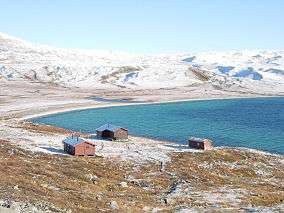 There are cabins and hiking routes in the park; Bjellåvasstua in the northeastern part near Bjellåvatnet | |
| Location | Nordland, Norway |
| Nearest city | Mo i Rana and Bodø |
| Coordinates | 66°36′N 14°11′E / 66.600°N 14.183°ECoordinates: 66°36′N 14°11′E / 66.600°N 14.183°E |
| Area | 2,102 km2 (812 sq mi) |
| Established | 1989 |
| Governing body | Directorate for Nature Management |
Saltfjellet–Svartisen National Park (Norwegian: Saltfjellet–Svartisen nasjonalpark) is a national park in Nordland county in Norway. It is located within the municipalities of Beiarn, Meløy, Rana, Rødøy, Saltdal, and Bodø. European route E06 and the Nordland Line both follow the southern and eastern borders around the park.[1] The park's eastern border is the Norway-Sweden border and a portion of this border is shared with the Vindelfjällen Nature Reserve (Sweden).
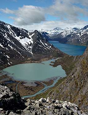
At 2,102 square kilometres (812 sq mi), it is one of the largest national parks in Norway. It is also one of the most varied, since it includes both alpine mountain formations with glacier tongues, as well as gently sloping mountain plateaus and forested valleys. The national park encompasses parts of the Saltfjellet mountain range. The Svartisen glacier is a central part of the park. There are also many Sami cultural landmarks within the park.
References
- ↑ Store norske leksikon. "Saltfjellet-Svartisen nasjonalpark" (in Norwegian). Retrieved 2011-12-13.