Nord-Rana
| Nord-Rana herred Mo herred | ||
|---|---|---|
| Former municipality | ||
| ||
 Nord-Rana within Nordland | ||
| Coordinates: 66°20′46″N 14°07′48″E / 66.34611°N 14.13000°ECoordinates: 66°20′46″N 14°07′48″E / 66.34611°N 14.13000°E | ||
| Country | Norway | |
| County | Nordland | |
| District | Helgeland | |
| Established | 1839 | |
| Disestablished | 1 Jan 1964 | |
| Administrative centre | Ytteren | |
| Area | ||
| • Total | 3,980 km2 (1,540 sq mi) | |
| *Area at municipal dissolution. | ||
| Population (1964) | ||
| • Total | 11,636 | |
| • Density | 2.9/km2 (7.6/sq mi) | |
| Demonym(s) |
Moværing Ranværing[1] | |
| Time zone | UTC+01:00 (CET) | |
| • Summer (DST) | UTC+02:00 (CEST) | |
| ISO 3166 code | NO-1833 | |
| Preceded by | Ranen in 1839 | |
| Succeeded by | Rana in 1964 | |
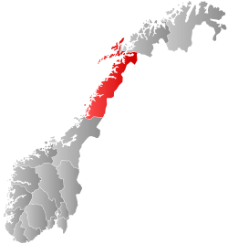
Nord-Rana (historically: Mo herred) is a former municipality in Nordland county, Norway. The 3,980-square-kilometre (1,540 sq mi) municipality existed from 1839 until its dissolution in 1964. From 1839 until 1844, it was named Nord-Ranen, from 1844 until 1923, it was called Mo, and then from 1923 until 1964 it was named Nord-Rana. The former municipality was located at the innermost part of the Ranfjorden. It encompassed the eastern 90% of what is now Rana Municipality. The administrative centre was the village of Ytteren, just north of the town of Mo i Rana.[2][3]
History
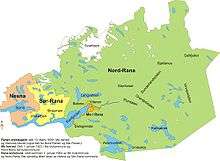
Rana Municipality was established on 1 January 1838 under the old formannskapsdistrikt law. Shortly afterwards, in 1839, the municipality was divided into Nord-Ranen and Sør-Ranen.[2] In 1844, Nord-Ranen was renamed Mo. On 1 January 1923, the village of Mo was designated as a ladested and so it was separated from the rest of the municipality to become a municipality of its own. The new town of Mo (population: 1,305) kept the name Mo and the rest of the old municipality became known as Nord-Rana (bringing back the old name for the area).
During the 1960s, there were many municipal mergers across Norway due to the work of the Schei Committee. On 1 January 1964, the municipality of Nord-Rana (population: 11,636) was merged with the town of Mo i Rana (population: 9,616), the part of the municipality of Sør-Rana located north of the Ranfjorden (population: 697), and the Sjona area of Nesna Municipality (population: 543) to create the large, new Rana Municipality.[4]
See also
References
- ↑ "Navn på steder og personer: Innbyggjarnamn" (in Norwegian). Språkrådet. Retrieved 2015-12-01.
- 1 2 Thorsnæs, Geir, ed. (2016-09-18). "Nord-Rana". Store norske leksikon (in Norwegian). Kunnskapsforlaget. Retrieved 2018-09-16.
- ↑ Helland, Amund (1908). "Mo herred". Norges land og folk: Nordlands amt (in Norwegian). XVIII. Kristiania, Norway: H. Aschehoug & Company. p. 446. Retrieved 2018-09-16.
- ↑ Jukvam, Dag (1999). "Historisk oversikt over endringer i kommune- og fylkesinndelingen" (PDF) (in Norwegian). Statistisk sentralbyrå.
| |||||||||||||||||
| |||||||||||||||||