Vega, Norway
| Vega kommune | |||
|---|---|---|---|
| Municipality | |||
 View of Nes harbour in Vega | |||
| |||
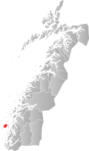 Vega within Nordland | |||
| Coordinates: 65°40′31″N 11°57′28″E / 65.67528°N 11.95778°ECoordinates: 65°40′31″N 11°57′28″E / 65.67528°N 11.95778°E | |||
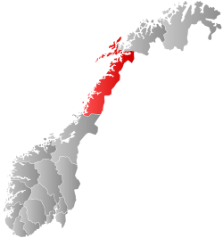
| Country | Norway | ||
| County | Nordland | ||
| District | Helgeland | ||
| Established | 1838 | ||
| Administrative centre | Gladstad | ||
| Government | |||
| • Mayor (2007) | Ingrid Solstrand (Ap) | ||
| Area | |||
| • Total | 164.79 km2 (63.63 sq mi) | ||
| • Land | 162.54 km2 (62.76 sq mi) | ||
| • Water | 2.25 km2 (0.87 sq mi) | ||
| Area rank | #350 in Norway | ||
| Population (2017) | |||
| • Total | 1,234 | ||
| • Rank | #377 in Norway | ||
| • Density | 7.6/km2 (20/sq mi) | ||
| • Change (10 years) | -5.0% | ||
| Demonym(s) | Vegværing[1] | ||
| Time zone | UTC+01:00 (CET) | ||
| • Summer (DST) | UTC+02:00 (CEST) | ||
| ISO 3166 code | NO-1815 | ||
| Official language form | Bokmål | ||
| Website |
vega | ||
| UNESCO World Heritage site | |
|---|---|
| Criteria | Cultural: v |
| Reference | 1143 |
| Inscription | 2004 (28th Session) |
| Area | 107,294 ha |
| Buffer zone | 28,952 ha |
Vega is a municipality in Nordland county, Norway. It is part of the Helgeland traditional region. The administrative centre of the municipality is the village of Gladstad. Other villages include Holand and Ylvingen.
The municipality comprises about 6,500 islands in the Vega Archipelago. The main island of the municipality is also called Vega, and it is also the largest at 163 square kilometres (63 sq mi). Bremstein Lighthouse is located in the southwestern part of the municipality.[2]
The 165-square-kilometre (64 sq mi) municipality is the 350th largest by area out of the 422 municipalities in Norway. Vega is the 377th most populous municipality in Norway with a population of 1,234. The municipality's population density is 7.6 inhabitants per square kilometre (20/sq mi) and its population has decreased by 5% over the last decade.[3]
General information
The municipality of Vega was established on 1 January 1838 (see formannskapsdistrikt). On 1 January 1965, the Skogsholmen area (population: 196) was transferred from Tjøtta to Vega. Then on 1 January 1971, the Skålvær islands (population: 32) in the northeastern part of Vega was transferred to Alstahaug.[4]
Name
The municipality is named after the main island of Vega (Old Norse: Veiga). The name is probably derived from veig which means "liquid" or "fluid" (referring to the lakes and the marshes of the island). The name was written "Vegø" prior to 1891.[5]
Coat-of-arms
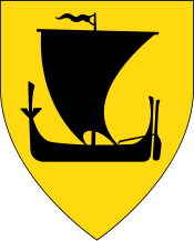
The coat-of-arms is from modern times; they were granted on 20 November 1987. The arms show a gold-colored bailer for a boat on a red background. A bailer is an essential tool that is important to the municipality due to its dependence on the sea. An earlier suggestion for the Vega coat-of-arms picturing the black silhouette of a sailing boat on a yellow background is now used as the coat-of-arms of Nordland county.[6]
Churches
The Church of Norway has one parish (sokn) within the municipality of Vega. It is part of the Sør-Helgeland prosti (deanery) in the Diocese of Sør-Hålogaland.
| Parish (Sokn) | Church Name | Location of the Church | Year Built |
|---|---|---|---|
| Vega | Vega Church | Gladstad | 1864 |
| Ylvingen Chapel | Ylvingen | 1967 |
History
Early settlements on the main island date back 10,000 years, making it one of the oldest places of inhabitance in Northern Norway. Agriculture and fishing are at present as they were in the past, key fields of labour. Today's inhabitants are concentrated in Holand, Valla, Igerøy, Ylvingen, and Gladstad, the latter being the location of the municipal council and most of the island's commerce.
Government
All municipalities in Norway, including Vega, are responsible for primary education (through 10th grade), outpatient health services, senior citizen services, unemployment and other social services, zoning, economic development, and municipal roads. The municipality is governed by a municipal council of elected representatives, which in turn elect a mayor.
Municipal council
The municipal council (Kommunestyre) of Vega is made up of 15 representatives that are elected to four year terms. Currently, the party breakdown is as follows:[7]
| Party Name | Name in Norwegian | Number of representatives | |
|---|---|---|---|
| Labour Party | Arbeiderpartiet | 8 | |
| Centre Party | Senterpartiet | 5 | |
| Socialist Left Party | Sosialistisk Venstreparti | 1 | |
| Local Lists | Lokale lister | 1 | |
| Total number of members: | 15 | ||
Geography
In 2004, the archipelago's cultural landscape was inscribed by UNESCO on the World Heritage Site list as representative of "the way generations of fishermen/farmers have, over the past 1,500 years, maintained a sustainable living in an inhospitable seascape near the Arctic Circle, based on the now unique practice of eider down harvesting." The oceanic climate and limestone bedrock has allowed 10 different species of orchids to grow in Vega, and 210 species of birds have been recorded at the archipelago.
Eidemsliene nature reserve has many warmth-loving species of plants and the most oceanic pine forest in North Norway.[8] Holandsosen nature reserve is an important wetland area with a shallow lake and soil rich in lime; 149 species of birds have been observed in this reserve which has a rich bird life all year (many birds use this as their winter quarter). Lånan nature reserve preserves many types of coastal nature and is a very important area for many species of birds; eider down harvesting is still practiced here.[9]
Media gallery
 The Vega islands
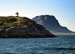 Søla island
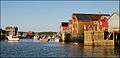 A summer day
References
- ↑ "Navn på steder og personer: Innbyggjarnamn" (in Norwegian). Språkrådet. Retrieved 2015-12-01.
- ↑ Store norske leksikon. "Vega (bilde)" (in Norwegian). Retrieved 2011-11-14.
- ↑ Statistisk sentralbyrå (2017). "Table: 06913: Population 1 January and population changes during the calendar year (M)" (in Norwegian). Retrieved 2017-09-23.
- ↑ Jukvam, Dag (1999). "Historisk oversikt over endringer i kommune- og fylkesinndelingen" (PDF) (in Norwegian). Statistisk sentralbyrå.
- ↑ Rygh, Oluf (1905). Norske gaardnavne: Nordlands amt (in Norwegian) (16 ed.). Kristiania, Norge: W. C. Fabritius & sønners bogtrikkeri. p. 32.
- ↑ "Kommunevåpenet" (in Norwegian). Vega Kommune. Archived from the original on 2009-08-17. Retrieved 2008-11-30.
- ↑ "Table: 04813: Members of the local councils, by party/electoral list at the Municipal Council election (M)" (in Norwegian). Statistics Norway. 2015.
- ↑ "Eidemsliene naturreservat" (in Norwegian). Archived from the original on 2012-04-17. Retrieved 2008-11-30.
- ↑ "Lånan - Skjærvær naturreservat/Fuglefredningsområde" (in Norwegian). Archived from the original on 2007-09-29. Retrieved 2008-11-30.
External links
| Wikimedia Commons has media related to Vega, Nordaland. |

- Municipal fact sheet from Statistics Norway (in Norwegian)
- Vega Havhotell (in Norwegian)
- Images of Vega Island and the surrounding region by Dana Morris
| |||||||||||||||||
| |||||||||||||||||
| Northern |
| |
|---|---|---|
| Trøndelag |
| |
| Western |
| |
| Eastern | ||
1 Shared with nine other countries | ||