Svartisen
| Svartisen | |
|---|---|
 Engabreen, Svartisen | |
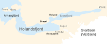
| Location | Saltdal, Rana, Rødøy, Meløy, Gildeskål, Beiarn and Bodø, Nordland, Norway |
| Coordinates | 66°38′N 14°00′E / 66.633°N 14.000°ECoordinates: 66°38′N 14°00′E / 66.633°N 14.000°E |
| Area | 369 km2 (142 sq mi) |
Svartisen is a collective term for two glaciers located in northern Norway. The system consists of two separate glaciers,
- Vestre (western) Svartisen (221 km2), which is the second largest glacier on the Norwegian mainland (there are larger glaciers on Svalbard) after Jostedalsbreen
- Østre (eastern) Svartisen (148 km2), which is the country's fourth largest.
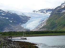
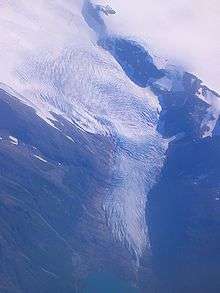
There are also a number of minor glaciers in the area, such as Glombreen in the northern part of Meløy, and Simlebreen in Beiarn. One of the outlet glaciers of Svartisen, Engabreen ends at the lowest point of any glacier on the European mainland, at 20 meters above sea level (in 2007). The Norwegian Water Resources and Energy Directorate has monitored the glacier mass balance of the glacier since 1970 and operates a sub-glacial laboratory beneath Engabreen.
Svartisen is part of Saltfjellet-Svartisen national park, located in the Saltfjell mountain range.
Water from the glacier is collected and used for hydropower production via runoff into the streams and lakes and through intakes borred beneath Engabreen.
| Wikimedia Commons has media related to Svartisen. |
The name
The first element is svart 'swart, black', the last element is the finite form of is m 'ice; glacier'. The old ice of the glacier is considerably darker than fresh ice and newfallen snow.
See also
External links
