Lødingen
| Lødingen kommune Lodegat | |||
|---|---|---|---|
| Municipality | |||
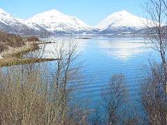
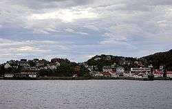 Lødingen village viewed from the ferry from Bognes | |||
| |||
| Nickname(s): Biketown | |||
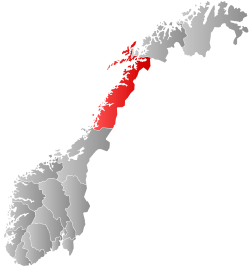
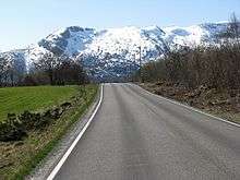
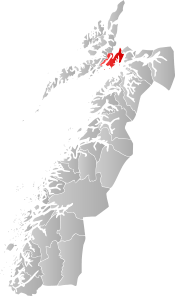 Lødingen within Nordland | |||
| Coordinates: 68°24′15″N 15°34′17″E / 68.40417°N 15.57139°ECoordinates: 68°24′15″N 15°34′17″E / 68.40417°N 15.57139°E | |||
| Country | Norway | ||
| County | Nordland | ||
| District | Ofoten | ||
| Established | 1838 | ||
| Administrative centre | Lødingen | ||
| Government | |||
| • Mayor (2015) | Atle Andersen (Ap) | ||
| Area | |||
| • Total | 527.49 km2 (203.67 sq mi) | ||
| • Land | 507.87 km2 (196.09 sq mi) | ||
| • Water | 19.62 km2 (7.58 sq mi) | ||
| Area rank | #203 in Norway | ||
| Population (2017) | |||
| • Total | 2,134 | ||
| • Rank | #318 in Norway | ||
| • Density | 4.2/km2 (11/sq mi) | ||
| • Change (10 years) | -5.4% | ||
| Demonym(s) | Lødingsværing[1] | ||
| Time zone | UTC+01:00 (CET) | ||
| • Summer (DST) | UTC+02:00 (CEST) | ||
| ISO 3166 code | NO-1851 | ||
| Official language form | Bokmål | ||
| Website |
lodingen | ||
Lødingen (Northern Sami: Lodegat) is a village and municipality in Nordland county in Norway. Lødingen is located on the southeastern corner of the island of Hinnøya, and is part of the traditional district of Ofoten. The administrative centre of the municipality is the village of Lødingen. The other main village is Vestbygda. Lødingen has the nickname "Biketown" because it hosts several annual bicycle races like Lofoten Insomnia and Vestbygd-rittet.
The 527-square-kilometre (203 sq mi) municipality is the 203rd largest by area out of the 422 municipalities in Norway. Lødingen is the 318th most populous municipality in Norway with a population of 2,134. The municipality's population density is 4.2 inhabitants per square kilometre (11/sq mi) and its population has decreased by 5.4% over the last decade.[2]
General information
The municipality of Lødingen was established on 1 January 1838 (see formannskapsdistrikt). On 1 January 1869, the southwestern district of Lødingen surrounding the Tysfjorden (population: 1,402) was separated to form the new municipality of Tysfjord. This left 2,064 residents in Lødingen. Then on 1 January 1909, the eastern district of Lødingen (population: 1,404) was separated to form the new municipality of Tjeldsund. This left 3,034 residents in Lødingen. On 1 January 1962, the southern part of Lødingen surrounding the Efjorden and the island of Barøya (population: 433) were transferred to the municipality of Ballangen. Then on 1 January 1964, the eastern part of Lødingen on the island of Tjeldøya (population: 297) was transferred to Tjeldsund.[3]
Name
The municipality (originally the parish) is named after the old Lødingen farm (Old Norse: Lǫðueng), since the first church was built there. The first element is the genitive case of laða which means "grain/hay barn" and the last element is eng which means "meadow".[4][5]
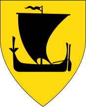
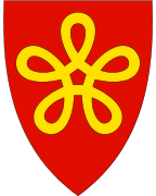
Coat-of-arms
The coat-of-arms is from modern times. They were granted on 11 May 1984. The arms show a gold-colored woollen thread that is folded as a flower with five leaves on a red background. The municipality is at the junction of road, shipping, and ferry routes to five areas: Lofoten, Ofoten, Salten, Vesterålen, and Southern Troms. It is also located between five fjords: Vestfjorden, Ofotfjorden, Tysfjorden, Tjeldsundet, and Gullesfjorden. The symbol is also an ancient symbol for good fortune.[6]
Churches
The Church of Norway has one parish (sokn) within the municipality of Lødingen. It is part of the Ofoten prosti (deanery) in the Diocese of Sør-Hålogaland.
| Parish (Sokn) | Church Name | Location of the Church | Year Built |
|---|---|---|---|
| Lødingen | Lødingen Church | Lødingen | 1897 |
| Vestbygd Church | Vågehamn | 1885 |
Government
All municipalities in Norway, including Lødingen, are responsible for primary education (through 10th grade), outpatient health services, senior citizen services, unemployment and other social services, zoning, economic development, and municipal roads. The municipality is governed by a municipal council of elected representatives, which in turn elect a mayor.
Municipal council
The municipal council (Kommunestyre) of Lødingen is made up of 17 representatives that are elected to four year terms. Currently, the party breakdown is as follows:[7]
| Party Name | Name in Norwegian | Number of representatives | |
|---|---|---|---|
| Labour Party | Arbeiderpartiet | 8 | |
| Progress Party | Fremskrittspartiet | 2 | |
| Conservative Party | Høyre | 3 | |
| Socialist Left Party | Sosialistisk Venstreparti | 2 | |
| Liberal Party | Venstre | 2 | |
| Total number of members: | 17 | ||
Geography
The municipality encompasses the southern part of the island of Hinnøya. The terrain is mountainous, with several small islands and fjords. The administrative centre of the municipality is the village of Lødingen, located at the inner part of the Vestfjorden at the southern entrance of the Tjeldsundet strait. The nearest airport is Harstad/Narvik Airport, Evenes, about 73 kilometres (45 mi) away by road. Lødingen is an important ferry harbor, the car ferry to/from Bognes in Tysfjord leaves 12 times per day and takes 60 minutes. Møysalen National Park is located in the northern part of the municipality. It's named after the mountain Møysalen on the border of Lødingen and Sortland.
Climate
| Climate data for Lødingen (village) | |||||||||||||
|---|---|---|---|---|---|---|---|---|---|---|---|---|---|
| Month | Jan | Feb | Mar | Apr | May | Jun | Jul | Aug | Sep | Oct | Nov | Dec | Year |
| Daily mean °C (°F) | −3.1 (26.4) |
−3.0 (26.6) |
−1.6 (29.1) |
1.5 (34.7) |
6.3 (43.3) |
10.0 (50) |
12.5 (54.5) |
12.0 (53.6) |
8.1 (46.6) |
4.2 (39.6) |
0.4 (32.7) |
−2.1 (28.2) |
3.8 (38.8) |
| Average precipitation mm (inches) | 158 (6.22) |
140 (5.51) |
114 (4.49) |
95 (3.74) |
71 (2.8) |
80 (3.15) |
100 (3.94) |
110 (4.33) |
157 (6.18) |
230 (9.06) |
160 (6.3) |
185 (7.28) |
1,600 (62.99) |
| Source: Norwegian Meteorological Institute[8] | |||||||||||||
Attractions
- Eye in Stone (Øye i stein), part of Artscape Nordland (Skulpturlandskap Nordland)
- Norwegian Telecom Museum, telegraphy
- Pilotage Service Museum
- Rotvær Lighthouse
References
- ↑ "Navn på steder og personer: Innbyggjarnamn" (in Norwegian). Språkrådet. Retrieved 2015-12-01.
- ↑ Statistisk sentralbyrå (2017). "Table: 06913: Population 1 January and population changes during the calendar year (M)" (in Norwegian). Retrieved 2017-09-16.
- ↑ Jukvam, Dag (1999). "Historisk oversikt over endringer i kommune- og fylkesinndelingen" (PDF) (in Norwegian). Statistisk sentralbyrå.
- ↑ Rygh, Oluf (1905). Norske gaardnavne: Nordlands amt (in Norwegian) (16 ed.). Kristiania, Norge: W. C. Fabritius & sønners bogtrikkeri. p. 297.
- ↑ Store norske leksikon. "Lødingen" (in Norwegian). Retrieved 2012-06-12.
- ↑ Norske Kommunevåpen (1990). "Nye kommunevåbener i Norden". Retrieved 2008-11-24.
- ↑ "Table: 04813: Members of the local councils, by party/electoral list at the Municipal Council election (M)" (in Norwegian). Statistics Norway. 2015.
- ↑ "eKlima Web Portal". Norwegian Meteorological Institute. Archived from the original on 2004-06-14.
External links
- Municipal fact sheet from Statistics Norway (in Norwegian)
| Wikimedia Commons has media related to Lødingen. |

- Skulpturlandskap Nordland (in Norwegian)
- Norwegian Telecom Museum (in Norwegian)
| |||||||||||||||||
| |||||||||||||||||