Sørfold
| Sørfold kommune | |||
|---|---|---|---|
| Municipality | |||
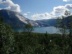
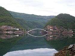
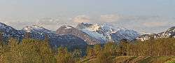 View of Kviturfjellet and Veikdalsisen | |||
| |||
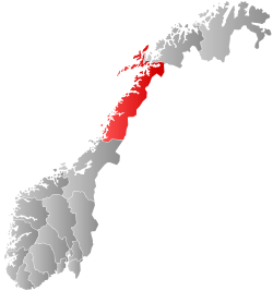
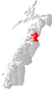 Sørfold within Nordland | |||
| Coordinates: 67°13′14″N 15°48′31″E / 67.22056°N 15.80861°ECoordinates: 67°13′14″N 15°48′31″E / 67.22056°N 15.80861°E | |||
| Country | Norway | ||
| County | Nordland | ||
| District | Salten | ||
| Established | 1887 | ||
| Administrative centre | Straumen | ||
| Government | |||
| • Mayor (2003) | Lars Evjenth (Ap) | ||
| Area | |||
| • Total | 1,637.35 km2 (632.18 sq mi) | ||
| • Land | 1,472.70 km2 (568.61 sq mi) | ||
| • Water | 164.65 km2 (63.57 sq mi) | ||
| Area rank | #41 in Norway | ||
| Population (2017) | |||
| • Total | 1,958 | ||
| • Rank | #331 in Norway | ||
| • Density | 1.3/km2 (3/sq mi) | ||
| • Change (10 years) | -6.0% | ||
| Demonym(s) | Sørfoldværing[1] | ||
| Time zone | UTC+01:00 (CET) | ||
| • Summer (DST) | UTC+02:00 (CEST) | ||
| ISO 3166 code | NO-1845 | ||
| Official language form | Bokmål | ||
| Website |
sorfold | ||

Sørfold is a municipality in Nordland county, Norway. It is part of the traditional district of Salten. The administrative centre of the municipality is the village of Straumen. Other villages in the municipality include Leirfjordgården, Mørsvikbotn, Røsvika, Rørstad, Styrkesvik, and Øvre Kvarv. The municipality surrounds the Sørfolda fjord and stretches east to the border with Sweden.
The 1,637-square-kilometre (632 sq mi) municipality is the 41st largest by area out of the 422 municipalities in Norway. Sørfold is the 331st most populous municipality in Norway with a population of 1,958. The municipality's population density is 1.3 inhabitants per square kilometre (3.4/sq mi) and its population has decreased by 6% over the last decade.[2]
General information
The municipality of Sørfolden was established on 1 January 1887 when the old municipality of Folden was divided into Sørfolden and Nordfold-Kjerringøy. Initially, the population of Sørfolden was 1,946. The spelling was later changed to just Sørfold. On 1 January 1894, the Movik farm (population: 30) along the Sagfjorden was transferred from Nordfold-Kjerringøy to Sørfold.
On 1 January 1964, the Øyjord area (population: 81) was transferred to the neighboring municipality of Bodin. On the same date, the Mørsvikbotn area (population: 268) was transferred from Nordfold to Sørfold. On 1 January 1984, the Tårnvika and Øygården area (population: 22) along the Sørfolda fjord was transferred from Sørfold to Bodø.[3]
Name
The municipality is named after the Folda fjord (Old Norse: Fold). The inner part of the fjord is divided into two arms Nordfolda ("the northern Folda") and Sørfolda ("the southern Folda"). The meaning of the fjord name is unknown (maybe "the broad one").[4]
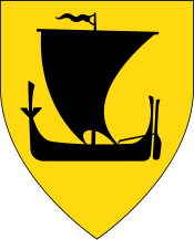
Coat-of-arms
The coat-of-arms is from modern times; they were granted on 24 April 1987. The arms show a silver wheel of a turbine in a hydroelectric power plant on a blue background. The rivers around the municipality contained many rapids and waterfalls, which are partly harnessed to generate electricity. This has provided a major source of income for the community.[5]
Churches
The Church of Norway has one parish (sokn) within the municipality of Sørfold. It is part of the Salten prosti (deanery) in the Diocese of Sør-Hålogaland.
| Parish (Sokn) | Church Name | Location of the Church | Year Built |
|---|---|---|---|
| Sørfold | Rørstad Church | Rørstad | 1761 |
| Røsvik Church | Røsvika | 1883 | |
| Mørsvikbotn Chapel | Mørsvikbotn | 1955 |
Geography
Sørfold municipality is located about 120 kilometres (75 mi) north of the Arctic circle. The total land area of Sørfold is 1,636.61 square kilometres (631.90 sq mi), of which 141 square kilometres (54 sq mi) is covered with permanent ice and snow, and only 265.8 square kilometres (102.6 sq mi) lies below the 150-metre (490 ft) contour line. The total length of coastline is 249 kilometres (155 mi). In 1987, only 3.2 square kilometres (1.2 sq mi) of land was being actively farmed.
To the north of Sørfold is the municipality of Hamarøy and to the south is Fauske municipality. To the east, the Sørfold borders Sweden and the Swedish municipality of Jokkmokk.
Rago National Park, with its wild nature dominated by bare rock, streams, and pine forest, is located in Sørfold. The glacier Blåmannsisen, one of the largest in Norway, is partly located in the municipality. There are several nature reserves. Veikdalen nature reserve, roughly 300 metres (980 ft) above sea level, protects a largely undisturbed pine and birch forest (some logging before 1918) with many standing dead pine trees.[6]
There are many large lakes in Sørfold, including Andkjelvatnet, Faulvatnet, Forsvatnet, Grovatnet, Horndalsvatnet, Kobbvatnet, Kvitvatnet, Langvatnet, Leirvatnet, Litlverivatnet, Mørsvikvatnet, Nedre Veikvatnet, Røyrvatnet, Rundvatnet, Sildhopvatnet, Sisovatnet, Storskogvatnet, Straumvatnet, and Trollvatnet.
Government
All municipalities in Norway, including Sørfold, are responsible for primary education (through 10th grade), outpatient health services, senior citizen services, unemployment and other social services, zoning, economic development, and municipal roads. The municipality is governed by a municipal council of elected representatives, which in turn elect a mayor.
Municipal council
The municipal council (Kommunestyre) of Sørfold is made up of 21 representatives that are elected to four year terms. Currently, the party breakdown is as follows:[7]
| Party Name | Name in Norwegian | Number of representatives | |
|---|---|---|---|
| Labour Party | Arbeiderpartiet | 10 | |
| Conservative Party | Høyre | 3 | |
| Centre Party | Senterpartiet | 6 | |
| Socialist Left Party | Sosialistisk Venstreparti | 2 | |
| Total number of members: | 21 | ||
History

The small village of Mørsvikbotn is located in the north part of the municipality. About 5 kilometres (3.1 mi) north of Mørsvikbotn lies the lake Mørsvikvatnet. In this area, Mørsry, the German army had a prisoner-of-war camp during World War II housing mostly Russian POWs. They were building the Polarbanen railway, which was intended to be a link between Fauske and Narvik. Some ruins of the camp, the foundations of the railway line, a tunnel, and roads can still be observed. A small, now empty, cemetery for fallen Russian soldiers is located close to the camp, about 50 metres (160 ft) off the left-hand side just before the single concrete bridge.
References
- ↑ "Navn på steder og personer: Innbyggjarnamn" (in Norwegian). Språkrådet. Retrieved 2015-12-01.
- ↑ Statistisk sentralbyrå (2017). "Table: 06913: Population 1 January and population changes during the calendar year (M)" (in Norwegian). Retrieved 2017-09-20.
- ↑ Jukvam, Dag (1999). "Historisk oversikt over endringer i kommune- og fylkesinndelingen" (PDF) (in Norwegian). Statistisk sentralbyrå.
- ↑ Rygh, Oluf (1905). Norske gaardnavne: Nordlands amt (in Norwegian) (16 ed.). Kristiania, Norge: W. C. Fabritius & sønners bogtrikkeri. p. 234.
- ↑ Norske Kommunevåpen (1990). "Nye kommunevåbener i Norden". Retrieved 2008-11-29.
- ↑ "Veikdalen naturreservat" (in Norwegian). Retrieved 2008-11-29.
- ↑ "Table: 04813: Members of the local councils, by party/electoral list at the Municipal Council election (M)" (in Norwegian). Statistics Norway. 2015.
External links
| Wikimedia Commons has media related to Sørfold. |

- Municipal fact sheet from Statistics Norway (in Norwegian)
| |||||||||||||||||
| |||||||||||||||||