Øksnes
| Øksnes kommune | |||
|---|---|---|---|
| Municipality | |||
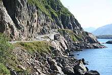
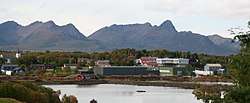 View of Alsvåg in Øksnes | |||
| |||
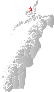 Øksnes within Nordland | |||
| Coordinates: 68°53′18″N 15°11′00″E / 68.88833°N 15.18333°ECoordinates: 68°53′18″N 15°11′00″E / 68.88833°N 15.18333°E | |||
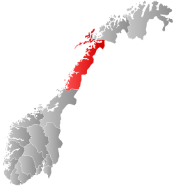
| Country | Norway | ||
| County | Nordland | ||
| District | Vesterålen | ||
| Established | 1838 | ||
| Administrative centre | Myre | ||
| Government | |||
| • Mayor (2015) | Karianne Bråthen (Ap) | ||
| Area | |||
| • Total | 319.51 km2 (123.36 sq mi) | ||
| • Land | 310.63 km2 (119.93 sq mi) | ||
| • Water | 8.88 km2 (3.43 sq mi) | ||
| Area rank | #266 in Norway | ||
| Population (2017) | |||
| • Total | 4,580 | ||
| • Rank | #217 in Norway | ||
| • Density | 14.7/km2 (38/sq mi) | ||
| • Change (10 years) | 2.1% | ||
| Demonym(s) | Øksnesværing[1] | ||
| Time zone | UTC+01:00 (CET) | ||
| • Summer (DST) | UTC+02:00 (CEST) | ||
| ISO 3166 code | NO-1868 | ||
| Official language form | Neutral | ||
| Website |
oksnes | ||

Øksnes is a municipality in Nordland county, Norway. It is located on the northwestern part of the large island of Langøya, which is a part of the traditional region of Vesterålen. The administrative centre of the municipality is the village of Myre. Other villages in Øksnes include Alsvåg, Barkestad, Breidstrand, Nyksund, Strengelvåg, and Stø.[2]
The 320-square-kilometre (120 sq mi) municipality is the 266th largest by area out of the 422 municipalities in Norway. Øksnes is the 217th most populous municipality in Norway with a population of 4,580. The municipality's population density is 14.7 inhabitants per square kilometre (38/sq mi) and its population has increased by 2.1% over the last decade.[3]
General information
The municipality of Øksnes was established on 1 January 1838 (see formannskapsdistrikt). On 1 January 1866, a small area of southern Øksnes (population: 40) was transferred to Bø. On 1 July 1919, the northeastern part of Øksnes along the Gavlfjorden (population: 1,085) was separated to form the new municipality of Langenes. This left Øksnes with 2,296 residents.
On 1 January 1964, the Krakberget area and the part of Øksnes on the peninsula north of Krakberget (population: 271) was transferred to Bø. On the same date the municipality of Langenes was merged with Øksnes. Prior to the merger, Øksnes had 3,112 residents and Langenes had 2,037 residents.[4]
Name
The municipality (originally the parish) is named after the old Øksnes farm (Old Norse: Yxnes), since the first church (Øksnes Church) was built there. The first element is probably an old name of Skogsøya island (Old Norse: Yxn) and the last element is nes which means "headland". The old name of the island is identical with the word yxn (plural form of uxi which means "ox"). The mountains of the island have maybe been compared with a group of oxen.[5]
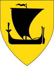
Coat-of-arms
The coat-of-arms is from modern times. They were granted on 22 August 1986. The arms show two black fishing hooks on a gold background, appropriate symbols for a municipality which is dependent on fishing and sailing.[6]
Churches
The Church of Norway has one parish (sokn) within the municipality of Øksnes. It is part of the Vesterålen prosti (deanery) in the Diocese of Sør-Hålogaland.
| Parish (Sokn) | Church Name | Location of the Church | Year Built |
|---|---|---|---|
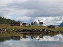
| Øksnes | Alsvåg Church | Alsvåg | 1923 |
| Langenes Church | Stø | 1500s | |
| Myre Church | Myre | 1979 | |
| Øksnes Church | Skogsøya | 1703 |
Geography
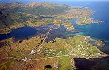
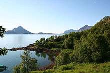
Øksnes municipality encompasses the northwestern part of the island of Langøya in the Vesterålen archipelago. It also includes many small islands around there including the islands of Anden, Dyrøya, Nærøya, Skogsøya, and Tindsøya. The Gavlfjorden flows along the northeastern part of the municipal boundary with Andøy municipality on the other side. The southeastern part of Øksnes borders Sortland municipality and the southwestern part borders Bø (both municipalities are also located on Langøya island). The rest of the municipality borders the Norwegian Sea.
The municipality is quite rugged with the exception of the area east of Myre which is very flat and marshy. The large lake Alsvågvatnet lies near this flat area, just east of the village of Alsvåg. This flat area lies just to the north of the large mountain Snøkolla. The Anda Lighthouse is located on the tiny island of Anden.
Climate
| Climate data for Myre, Øksnes | |||||||||||||
|---|---|---|---|---|---|---|---|---|---|---|---|---|---|
| Month | Jan | Feb | Mar | Apr | May | Jun | Jul | Aug | Sep | Oct | Nov | Dec | Year |
| Daily mean °C (°F) | −2.0 (28.4) |
−2.0 (28.4) |
−1.0 (30.2) |
1.5 (34.7) |
5.8 (42.4) |
9.1 (48.4) |
11.6 (52.9) |
11.5 (52.7) |
8.1 (46.6) |
4.5 (40.1) |
1.2 (34.2) |
−1.0 (30.2) |
3.9 (39) |
| Average precipitation mm (inches) | 130 (5.12) |
121 (4.76) |
105 (4.13) |
91 (3.58) |
64 (2.52) |
69 (2.72) |
82 (3.23) |
86 (3.39) |
141 (5.55) |
195 (7.68) |
146 (5.75) |
150 (5.91) |
1,380 (54.33) |
| Source: Norwegian Meteorological Institute[7] | |||||||||||||
Government
All municipalities in Norway, including Øksnes, are responsible for primary education (through 10th grade), outpatient health services, senior citizen services, unemployment and other social services, zoning, economic development, and municipal roads. The municipality is governed by a municipal council of elected representatives, which in turn elect a mayor.
Municipal council
The municipal council (Kommunestyre) of Øksnes is made up of 21 representatives that are elected to four year terms. Currently, the party breakdown is as follows:[8]
| Party Name | Name in Norwegian | Number of representatives | |
|---|---|---|---|
| Labour Party | Arbeiderpartiet | 6 | |
| Progress Party | Fremskrittspartiet | 2 | |
| Conservative Party | Høyre | 2 | |
| Christian Democratic Party | Kristelig Folkeparti | 1 | |
| Centre Party | Senterpartiet | 4 | |
| Socialist Left Party | Sosialistisk Venstreparti | 2 | |
| Local Lists | Lokale lister | 4 | |
| Total number of members: | 21 | ||
References
- ↑ "Navn på steder og personer: Innbyggjarnamn" (in Norwegian). Språkrådet. Retrieved 2015-12-01.
- ↑ Store norske leksikon. "Øksnes" (in Norwegian). Retrieved 2012-08-03.
- ↑ Statistisk sentralbyrå (2017). "Table: 06913: Population 1 January and population changes during the calendar year (M)" (in Norwegian). Retrieved 2017-09-19.
- ↑ Jukvam, Dag (1999). "Historisk oversikt over endringer i kommune- og fylkesinndelingen" (PDF) (in Norwegian). Statistisk sentralbyrå.
- ↑ Rygh, Oluf (1905). Norske gaardnavne: Nordlands amt (in Norwegian) (16 ed.). Kristiania, Norge: W. C. Fabritius & sønners bogtrikkeri. pp. 382, 387.
- ↑ Norske Kommunevåpen (1990). "Nye kommunevåbener i Norden". Retrieved 2008-11-30.
- ↑ "eKlima Web Portal". Norwegian Meteorological Institute. Archived from the original on 2004-06-14.
- ↑ "Table: 04813: Members of the local councils, by party/electoral list at the Municipal Council election (M)" (in Norwegian). Statistics Norway. 2015.
External links
- Municipal fact sheet from Statistics Norway (in Norwegian)
| Wikimedia Commons has media related to Øksnes. |

| |||||||||||||||||
| |||||||||||||||||