Brønnøy
| Brønnøy kommune | |||
|---|---|---|---|
| Municipality | |||
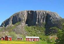
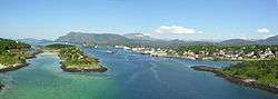 View of Brønnøysund | |||
| |||
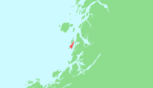
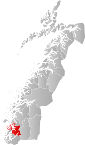 Brønnøy within Nordland | |||
| Coordinates: 65°28′33″N 12°24′01″E / 65.47583°N 12.40028°ECoordinates: 65°28′33″N 12°24′01″E / 65.47583°N 12.40028°E | |||
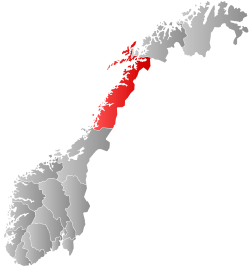
| Country | Norway | ||
| County | Nordland | ||
| District | Helgeland | ||
| Established | 1838 | ||
| Administrative centre | Brønnøysund | ||
| Government | |||
| • Mayor (2013) | Johnny Hanssen (Ap) | ||
| Area | |||
| • Total | 1,046.44 km2 (404.03 sq mi) | ||
| • Land | 1,000.52 km2 (386.30 sq mi) | ||
| • Water | 45.92 km2 (17.73 sq mi) | ||
| Area rank | #99 in Norway | ||
| Population (2017) | |||
| • Total | 7,956 | ||
| • Rank | #138 in Norway | ||
| • Density | 8.0/km2 (21/sq mi) | ||
| • Change (10 years) | 5.4% | ||
| Demonym(s) | Brønnøyværing[1] | ||
| Time zone | UTC+01:00 (CET) | ||
| • Summer (DST) | UTC+02:00 (CEST) | ||
| ISO 3166 code | NO-1813 | ||
| Official language form | Neutral | ||
| Website |
bronnoy | ||
Brønnøy is a municipality in Nordland county, Norway. It is part of the Helgeland region. The administrative and commercial centre is the town of Brønnøysund. A secondary centre is the village of Hommelstø. Other villages include Tosbotn, Lande, Trælnes, and Indreskomo.
The Brønnøysund Register Centre is an important employer in Brønnøy. Also, one of the largest limestone mines in Northern Europe is located in the municipality. Brønnøysund Airport, Brønnøy is located near the town of Brønnøysund.
The 1,046-square-kilometre (404 sq mi) municipality is the 99th largest by area out of the 422 municipalities in Norway. Brønnøy is the 138th most populous municipality in Norway with a population of 7,956. The municipality's population density is 8 inhabitants per square kilometre (21/sq mi) and its population has increased by 5.4% over the last decade.[2]
General information
The municipality of Brønnøy was established on 1 January 1838 (see formannskapsdistrikt). On 1 October 1875 the eastern district (population: 1,162) was separated to become the new municipality of Velfjord. This left Brønnøy with 4,156 residents.
Then on 1 January 1901, the southwestern district (population: 2,731) was separated to become the new municipality of Vik (which later changed its name to Sømna). Brønnøy was then left with 3,440 inhabitants. On 1 January 1923 the large village of Brønnøysund (population: 948) was separated from Brønnøy to become a town (ladested).
On 1 January 1964, a major municipal merger took place. The municipalities of Sømna, Velfjord, Brønnøy, the town of Brønnøysund, and the Lande area of Bindal were all merged to form a new, larger municipality of Brønnøy. Just thirteen years later on 1 January 1977, the former municipality of Sømna was separated from Brønnøy once again to become its own municipality.[3]
Name
The municipality (originally the parish) is named after the small island Brønnøya (Old Norse: Brunnøy), since the first church was built there. The first element is brunnr which means "well" and the last element is øy which means "island". Islands with freshwater wells were important for seafarers.[4]
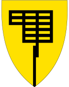
Coat-of-arms
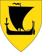
The coat-of-arms is from modern times; they were granted on 20 May 1988. The arms have a yellow background with a black direction-sign used in the harbor to guide the ships. It symbolizes the importance of the harbor for the municipality.[5]
Churches
The Church of Norway has two parishes (sokn) within the municipality of Brønnøy. It is part of the Sør-Helgeland prosti (deanery) in the Diocese of Sør-Hålogaland.
| Parish (Sokn) | Church Name | Location of the Church | Year Built |
|---|---|---|---|
| Brønnøy | Brønnøy Church | Brønnøysund | 1870 |
| Skogmo Chapel | Indreskomo | 1979 | |
| Trælnes Chapel | Trælnes | 1980 | |
| Velfjord og Tosen | Nøstvik Church | Velfjord | 1674 |
| Tosen Chapel | Lande | 1734 |
Geography
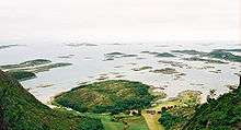
The municipality has great scenic variety with numerous islets, lakes (such as Eidevatnet, Sausvatnet, and Fjellvatnet), mountains, and some fertile agricultural areas. Torget island is connected to the mainland via the Brønnøysund Bridge.
Brønnøy borders the municipalities of Vega and Vevelstad to the north, Vefsn and Grane to the east, and Bindal and Sømna to the south. The large fjord Velfjorden runs into the heart of the municipality.
Nature
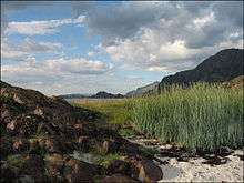
In the southwest is the island of Torget, with the mountain Torghatten, is famous for a cavity that goes straight through the structure. Lomsdal–Visten National Park is located in the northeastern part of Brønnøy.
The world's most northerly naturally occurring small-leaved lime (linden) forests grows in Brønnøy, and there are patches of boreal rainforests in Grønlidalen nature reserve[6] and Storhaugen nature reserve.[7] Strompdalen nature reserve[8] and Horsvær nature reserve, a nesting place for a rich variety of seabirds, are also located in the municipality.
Government
All municipalities in Norway, including Brønnøy, are responsible for primary education (through 10th grade), outpatient health services, senior citizen services, unemployment and other social services, zoning, economic development, and municipal roads. The municipality is governed by a municipal council of elected representatives, which in turn elect a mayor.
Municipal council
The municipal council (Kommunestyre) of Brønnøy is made up of 27 representatives that are elected to four year terms. Currently, the party breakdown is as follows:[9]
| Party Name | Name in Norwegian | Number of representatives | |
|---|---|---|---|
| Labour Party | Arbeiderpartiet | 10 | |
| Conservative Party | Høyre | 4 | |
| Centre Party | Senterpartiet | 6 | |
| Socialist Left Party | Sosialistisk Venstreparti | 1 | |
| Liberal Party | Venstre | 6 | |
| Total number of members: | 27 | ||
See also
References
- ↑ "Navn på steder og personer: Innbyggjarnamn" (in Norwegian). Språkrådet. Retrieved 2015-12-01.
- ↑ Statistisk sentralbyrå (2017). "Table: 06913: Population 1 January and population changes during the calendar year (M)" (in Norwegian). Retrieved 2017-09-09.
- ↑ Jukvam, Dag (1999). "Historisk oversikt over endringer i kommune- og fylkesinndelingen" (PDF) (in Norwegian). Statistisk sentralbyrå.
- ↑ Rygh, Oluf (1905). Norske gaardnavne: Nordlands amt (in Norwegian) (16 ed.). Kristiania, Norge: W. C. Fabritius & sønners bogtrikkeri. p. 15.
- ↑ Norske Kommunevåpen (1990). "Nye kommunevåbener i Norden". Retrieved 2008-11-19.
- ↑ "Grønlidalen naturreservat" (in Norwegian). Retrieved 2011-09-24.
- ↑ http://nordland.miljostatus.no/Storhaugen Nature Reserve Archived April 2, 2012, at the Wayback Machine.
- ↑ "Strompdalen naturreservat" (in Norwegian). Archived from the original on 2012-04-16. Retrieved 2008-11-19.
- ↑ "Table: 04813: Members of the local councils, by party/electoral list at the Municipal Council election (M)" (in Norwegian). Statistics Norway. 2015.
External links
- Municipal fact sheet from Statistics Norway (in Norwegian)
| Wikimedia Commons has media related to Brønnøy. |

| |||||||||||||||||
| |||||||||||||||||
| Authority control |
|---|