Bø, Nordland
| Bø kommune | |||
|---|---|---|---|
| Municipality | |||
 | |||
| |||
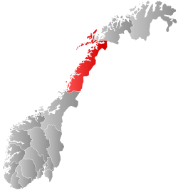
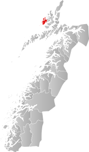 Bø within Nordland | |||
| Coordinates: 68°41′43″N 14°34′46″E / 68.69528°N 14.57944°ECoordinates: 68°41′43″N 14°34′46″E / 68.69528°N 14.57944°E | |||
| Country | Norway | ||
| County | Nordland | ||
| District | Vesterålen | ||
| Established | 1838 | ||
| Administrative centre | Straume | ||
| Government | |||
| • Mayor (2007) | Sture Pedersen (H) | ||
| Area | |||
| • Total | 246.69 km2 (95.25 sq mi) | ||
| • Land | 234.86 km2 (90.68 sq mi) | ||
| • Water | 11.83 km2 (4.57 sq mi) | ||
| Area rank | #307 in Norway | ||
| Population (2017) | |||
| • Total | 2,624 | ||
| • Rank | #286 in Norway | ||
| • Density | 11.2/km2 (29/sq mi) | ||
| • Change (10 years) | -9.5% | ||
| Demonym(s) | Bøfjerding[1] | ||
| Time zone | UTC+01:00 (CET) | ||
| • Summer (DST) | UTC+02:00 (CEST) | ||
| ISO 3166 code | NO-1867 | ||
| Official language form | Neutral | ||
| Website |
boe | ||

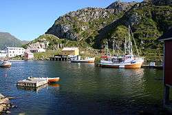
Bø is a village and municipality in Nordland county, Norway. It is part of the Vesterålen region. The administrative centre of the municipality is the village of Straume. Other villages in the municipality include Bø, Eidet, Hovden, Nykvåg, and Utskor. The Litløy Lighthouse is located on the tiny island of Litløya off the coast of Bø.
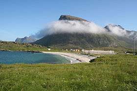
The village of Bø is located on the southern coast of the municipality. It is made up of several populated areas such as Steine and Vinje. Bø Church is located in the eastern part of this village. The 1.41-square-kilometre (350-acre) village of Bø has a population (2011) of 726, giving the village a population density of 515 inhabitants per square kilometre (1,330/sq mi).[2]
The 247-square-kilometre (95 sq mi) municipality is the 307th largest by area out of the 422 municipalities in Norway. Bø is the 286th most populous municipality in Norway with a population of 2,624. The municipality's population density is 11.2 inhabitants per square kilometre (29/sq mi) and its population has decreased by 9.5% over the last decade.[3]
General information

The municipality of Bø was established on 1 January 1838 (see formannskapsdistrikt). On 1 January 1866, a small area of Øksnes (population: 40) was transferred to Bø. On 1 January 1964, the Kråkberget village and the peninsula north of Kråkberget (population: 271) was transferred from Øksnes to Bø.[4]
Name
The municipality (originally the parish) is named after the old Bø farm (Old Norse: Bœr), since the first church (Bø Church) was built there. The name is identical with the word bœr which means "farm" and it is a cognate with the Dutch language word "boer" which means "farmer".[5]
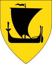
Coat-of-arms
The coat-of-arms is from modern times. They were granted on 7 August 1987. The arms show a silver "half boat" on a black background. This was chosen to represent the importance of fishing in Bø, but also reminiscent of some old legends/fairy tales in the region that include a "half boat". (The seaghost draugr travelled in a half boat.)[6]
Touristic attraction - Man from the Sea
Looking out to sea from a rise above Vinje in Bø in Vesterålen stands the 'Man from the Sea', a 4.3-metre (14 ft) high figure of a man made from cast iron. The man is holding a crystal in his hands like a sacrifice to the sea. In the winter light, the crystal turns blue. The man stands with his back to the village of Bø, and looks out over the craggy archipelago towards the distinctive silhouette of Gaukværøya island.[7]
Churches
The Church of Norway has one parish (sokn) within the municipality of Bø. It is part of the Vesterålen prosti (deanery) in the Diocese of Sør-Hålogaland.
| Parish (Sokn) | Church Name | Location of the Church | Year Built |
|---|---|---|---|
| Bø og Malnes | Bø Church | Bø | 1824 |
| Malnes Church | Eide | 1895 |
Population
The municipality has sustained a steady decline in population since the 1950s when 6,122 people lived in Bø. The 2001 census showed that the population had declined to 3,156,[8] while the fourth quarter population estimate for 2007 showed the population at 2866.[9] The bureau of statistics projects a continued population decline.[10]
The municipality has 73 gårdsnummer in the cadastre.[11] The largest and densest population center is the Vinje, Skagen, and Steine area in the southwestern part of the municipality,[12] which is designated as the village ("tettsted") of "Bø" by the bureau of statistics.
Government
All municipalities in Norway, including Bø, are responsible for primary education (through 10th grade), outpatient health services, senior citizen services, unemployment and other social services, zoning, economic development, and municipal roads. The municipality is governed by a municipal council of elected representatives, which in turn elect a mayor.
Municipal council
The municipal council (Kommunestyre) of Bø is made up of 19 representatives that are elected to four year terms. Currently, the party breakdown is as follows:[13]
| Party Name | Name in Norwegian | Number of representatives | |
|---|---|---|---|
| Progress Party | Fremskrittspartiet | 1 | |
| Centre Party | Senterpartiet | 2 | |
| Socialist Left Party | Sosialistisk Venstreparti | 1 | |
| Liberal Party | Venstre | 3 | |
| Local Lists | Lokale lister | 12 | |
| Total number of members: | 19 | ||
Geography
The municipality of Bø lies on the island of Langøya and many small surrounding islets including Litløya and Gaukværøy. There is one road that connects Bø to the rest of Norway via the 1,612-metre (5,289 ft) long Ryggedal Tunnel, connecting Bø to Øksnes and Sortland.
Climate
| Climate data for Bø i Vesterålen | |||||||||||||
|---|---|---|---|---|---|---|---|---|---|---|---|---|---|
| Month | Jan | Feb | Mar | Apr | May | Jun | Jul | Aug | Sep | Oct | Nov | Dec | Year |
| Average high °C (°F) | 0.8 (33.4) |
0.6 (33.1) |
1.6 (34.9) |
4.2 (39.6) |
9.2 (48.6) |
12.7 (54.9) |
15.2 (59.4) |
14.7 (58.5) |
10.8 (51.4) |
6.9 (44.4) |
3.4 (38.1) |
1.5 (34.7) |
6.8 (44.2) |
| Daily mean °C (°F) | −1.4 (29.5) |
−1.5 (29.3) |
−0.6 (30.9) |
1.9 (35.4) |
6.4 (43.5) |
9.7 (49.5) |
12.1 (53.8) |
11.9 (53.4) |
8.3 (46.9) |
4.8 (40.6) |
1.4 (34.5) |
−0.8 (30.6) |
4.4 (39.9) |
| Average low °C (°F) | −4.6 (23.7) |
−4.7 (23.5) |
−3.6 (25.5) |
−0.9 (30.4) |
3.0 (37.4) |
6.6 (43.9) |
8.9 (48) |
8.5 (47.3) |
5.5 (41.9) |
2.2 (36) |
−1.4 (29.5) |
−3.8 (25.2) |
1.3 (34.3) |
| Average precipitation mm (inches) | 88 (3.46) |
81 (3.19) |
70 (2.76) |
63 (2.48) |
48 (1.89) |
56 (2.2) |
73 (2.87) |
74 (2.91) |
110 (4.33) |
144 (5.67) |
103 (4.06) |
107 (4.21) |
1,017 (40.04) |
| Average precipitation days (≥ 1 mm) | 15.4 | 13.8 | 13.2 | 12.7 | 10.3 | 10.5 | 12.7 | 11.6 | 16.5 | 18.8 | 17.2 | 17.8 | 170.3 |
| Source: Norwegian Meteorological Institute[14] | |||||||||||||
References
- ↑ "Navn på steder og personer: Innbyggjarnamn" (in Norwegian). Språkrådet. Retrieved 2015-12-01.
- ↑ Statistisk sentralbyrå (1 January 2011). "Urban settlements. Population and area, by municipality". Archived from the original on 14 November 2011.
- ↑ Statistisk sentralbyrå (2017). "Table: 06913: Population 1 January and population changes during the calendar year (M)" (in Norwegian). Retrieved 2017-09-09.
- ↑ Jukvam, Dag (1999). "Historisk oversikt over endringer i kommune- og fylkesinndelingen" (PDF) (in Norwegian). Statistisk sentralbyrå.
- ↑ Rygh, Oluf (1905). Norske gaardnavne: Nordlands amt (in Norwegian) (16 ed.). Kristiania, Norge: W. C. Fabritius & sønners bogtrikkeri. p. 374.
- ↑ "Fakta om Eventyrkommunen" (in Norwegian). Bø kommune i Vesterålen. Archived from the original on 2012-06-17. Retrieved 2008-11-19.
- ↑ "Man from the sea" (in Norwegian). Northern Norway Tourist Board. Retrieved 2017-11-07.
- ↑ "Bø Kommune" (PDF) (in Norwegian). Statistics Norway.
- ↑ "Population estimates October 1, 2007 for Nordland" (in Norwegian). Statistics Norway. Retrieved 2008-11-19.
- ↑ "Figures for Bø Kommune" (in Norwegian). Statistics Norway. Retrieved 2008-11-19.
- ↑ "Kuling 2.0" (in Norwegian). Archived from the original on 2012-06-17. See list of gårdsnummer in right column
- ↑ "Kuling 2.0 entry on Vinje gård" (in Norwegian). Archived from the original on 2009-02-10.
- ↑ "Table: 04813: Members of the local councils, by party/electoral list at the Municipal Council election (M)" (in Norwegian). Statistics Norway. 2015.
- ↑ "eKlima Web Portal". Norwegian Meteorological Institute. Archived from the original on 2004-06-14.
External links
- Municipal fact sheet from Statistics Norway (in Norwegian)

| |||||||||||||||||
| |||||||||||||||||