Qijin District, Kaohsiung
| Cijin 旗津區 Qijin | |
|---|---|
| District | |
| Cijin District[1] | |
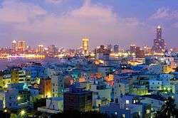 | |
 Cijin District in Kaohsiung City | |
| Country | Taiwan |
| Region | Southern Taiwan |
| Population (January 2016) | |
| • Total | 28,992 |
| Website | Official Website (in Chinese) |

Qijin District (Chinese: 旗津區; Hanyu Pinyin: Qíjīn Qū; Tongyong Pinyin: Cíjin Cyu; Wade–Giles: Ch'i2-chin1 Ch'ü1; Pe̍h-ōe-jī: Kî-tin-khu) is a district of Kaohsiung City, Taiwan, covering Qijin Island. It is the second smallest district in Kaohsiung City after Yancheng District.
History
Qijin forms the original core of the Kaohsiung, which was established by the fisherman Hsu Ah-hua (徐阿華) in the mid-17th century. He realized the attractiveness of the location when he was forced to seek shelter from a typhoon in the Taiwan Strait and returned with settlers from the Hung, Wang, Cai, Li, Bai, and Pan families and an idol of the Chinese sea goddess Mazu. This was housed in a bamboo and thatch structure that formed the first Chi Jin Mazu Temple. The town grew up around the temple grounds.[2]
Qijin Island was once connected to the mainland at the southern tip, but in 1967, this link was severed to create a second entry point to the Port of Kaohsiung.
Geography
Two islands and one reef in the South China Sea are administered by Kaohsiung City as parts of Cijin District:
- Pratas Islands (aka Dongsha Islands)
- Taiping Island
- Zhongzhou Reef
Government
The representative for Qijin on the city council is Lee Chiao-Ju.[3]
Economy
Most of its residents are employed by the shipping industry. There is a park on the north western shore.
History
Xiaogang was developed during Dutch era. The Dutch built Ang mo Harbor as an addition to Anping Harbor in Tainan. After losing the war against Koxinga, the Dutch left Taiwan. Koxinga's government developed Taiwan as the base to revive the Ming Dynasty and prepare his troops for fighting the Qing dynasty. He sent one of his men, Wu Yanshang, to expand Xiaogang. After Koxinga, his son, and his grandson died, the Qing quickly defeated the Ming remnants and annexed Taiwan.
Empire of Japan
In 1895, the Qing dynasty ceded Taiwan to Japan in the Treaty of Shimonoseki after losing the First Sino-Japanese War, and Xiaogang was used to produce sugar for Japanese. In 1920, the original name of Kang-a-ki (Chinese: 港仔墘; Pe̍h-ōe-jī: Káng-á-kîⁿ) was changed, and the incorporated areas were administered as Kominato Village (小港庄) under Hōzan District, Takao Prefecture. As a heavy industry base in Taiwan during World War II, Xiaogang was more heavily bombed by the Allied force than other parts of the city.
Republic of China
After the war and the handover of Taiwan from Japan to the Republic of China, Xiaogang was administrated as Xiaogang Township of Kaohsiung County, a third-level government of the Republic of China, under Taiwan Province. Xiaogang was annexed by Kaohsiung City and become Xiaogang District on 1 July 1979, when Kaohsiung City became a special municipality.
Geography
Xiaogang is located in the southern part of Kaohsiung. It borders Qianzhen District to the north, Daliao Township to the east, Linyuan Township to the south, and the Taiwan Strait to the west.
Economy
As far as the industry of Taiwan is concerned, Xiaogang is one of the most important regions for the shipbuilding and steel industries. During the 1970s, the government spent 5 years carrying out Ten Major Construction Projects. Two companies resulting from the projects are based here: China Steel and CSBC Corporation, Taiwan. CPC Corporation, Taiwan also a part of the ten projects, has a major oil refinery facility located here. With the proximity of Kaohsiung Harbor, the products of these companies are exported worldwide. These products are also transported throughout the island via National Highway No. 1 (Taiwan), which terminates on the northern border of the district.
Education
Elementary Schools
- Kaohsiung Municipal Cijin Elementary School
- Kaohsiung Municipal Dashan Elementary School
- Kaohsiung Municipal Zhongzhou Elementary School
Junior High Schools
- Kaohsiung Municipal Cijin Junior High School
Universities
- National Kaohsiung University of Science and Technology (Cijin District)
Tourist attractions
Transportation
The "Cross Harbor Tunnel" (Chinese: 過港隧道) connects Cijin Island at the EBC tip to the rest of Kaohsiung on mainland Taiwan. Cijin District is also accessible by two ferry piers, the Cijin Ferry Pier at the northern tip of the island and the Zhongzhou Ferry Pier at the middle of the island.
References
- ↑ "Administrative Districts". 高雄市政府. 30 September 2016. Retrieved 4 April 2017.
- ↑ "Tianhou Temple at Cihou", Official site, Kaohsiung: Bureau of Cultural Affairs of the Kaohsiung City Government, 2008 . (in Chinese) & (in English)
- ↑ "4.Members Introduction: Lee, Chiao-Ju". Kaohsiung City Council. Retrieved 22 February 2017.
External links
| Wikimedia Commons has media related to Cijin District, Kaohsiung. |
Districts of Kaohsiung | ||
|---|---|---|
| Urban area | .svg.png) | |
| Fongshan region | ||
| Gangshan region | ||
| Cishan region | ||
| Mountain indigenous districts | ||
Note: Although Hanyu Pinyin is the national standard, the Kaohsiung Government names its districts based on Tongyong Pinyin. | ||
| Kaohsiung |  | |
|---|---|---|
| Kinmen | ||
| Lienchiang1 | ||
| Penghu | ||
| Pingtung | ||
| Taitung | ||
| Yilan | ||
1 Lienchiang County commonly known as Matsu. 2Diaoyutai Islands are controlled by Japan, (called Senkaku Islands). 3Seat of the outlying islands' counties | ||
Coordinates: 22°33′42″N 120°18′25″E / 22.561674°N 120.306998°E