Shulin District
| Shulin 樹林區 | |
|---|---|
| District | |
| Shulin District | |
 | |
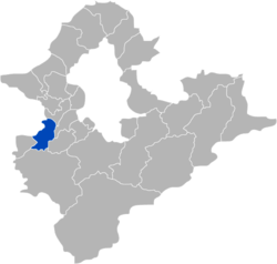 Shulin District in New Taipei City | |
| Coordinates: 24°59′N 121°25′E / 24.99°N 121.41°ECoordinates: 24°59′N 121°25′E / 24.99°N 121.41°E | |
| Country | Republic of China (Taiwan) |
| Special municipality | New Taipei City |
| Area | |
| • Total | 33.1288 km2 (12.7911 sq mi) |
| Population (January 2016) | |
| • Total | 184,329 |
| Time zone | +8 |
| Website | www.shulin.ntpc.gov.tw |
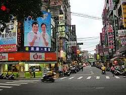
Shulin District (Chinese: 樹林區; pinyin: Shùlín Qū; Pe̍h-ōe-jī: Chhiū-nâ-chhī) is an inner city district in southwestern New Taipei City, Taiwan.[1]
Name
The area was named Shulin by the daily business commuters after seeing the sights of abundance of woods and trees in the region.
History
Shulin was upgraded to a county-controlled city of Taipei County on 4 October 1999 from a township, and to a district of New Taipei City on 25 December 2010.
Administrative divisions
Sanxing, Sanfu, Sanduo, Sanlong, Qiangliao, Guangxing, Jinliao, Tande, Wenlin, Baoan, Zunan, Zunfu, Zunmin, Zunsheng, Shude, Shufu, Shuxi, Shuxing, Shuren, Yuying, Shunan, Ponei, Shutung, Shubei, Pengfu, Heping, Pengxing, Pengcuo, Datong, Zhonghua, Taishun, Tungsheng, Tungyang, Tungshan, Shanjia, Zhongshan, Leshan, Ganyuan, Xiyuan, Nanyuan, Tungyuan and Beiyuan Village.
Infrastructures
Transportation

See also
| Wikimedia Commons has media related to Shulin District, New Taipei. |
References
City seat: Banqiao | ||
| Northern |  | |
| Eastern | ||
| Western | ||
| Southern | ||
| Mountain indigenous district | ||
Note: Although Hanyu Pinyin is the national standard, the municipal government endorses and uses "New Taipei" instead of "Xinbei" and "Tamsui" instead of "Danshui." | ||