Yangmei District
| Yangmei 楊梅區 | |
|---|---|
| District | |
| Yangmei District | |
 | |
 | |
| Coordinates: 24°56′00″N 121°17′00″E / 24.93333°N 121.28333°E | |
| Country | Taiwan |
| Municipality | Taoyuan City |
| Government | |
| • Mayor | Yao Dun-Ming |
| Area | |
| • Total | 89.1229 km2 (34.4105 sq mi) |
| Population (January 2016) | |
| • Total | 161,301 |
| • Density | 1,800/km2 (4,700/sq mi) |
| Website |
www |
Yangmei District (Chinese: 楊梅區; pinyin: Yángméi Qū) is a district in southwestern Taoyuan City, Taiwan. The traditional residents are Hakka people.[1]
History
Yangmei City was originally established as Yangmeili (Chinese: 楊梅壢; Pe̍h-ōe-jī: Iûⁿ-mûi-le̍k) during Qing dynasty rule. The name was shortened Yōbai (Japanese: 楊梅) in 1920, during Japanese rule.[2] Under the Republic of China, the former township was upgraded to a county-controlled city after passing 150,000 in population. On 25 December 2014, it was upgraded again to a district.
Geography
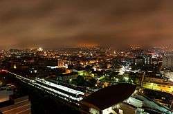
Yangmei is the third largest district in Taoyuan City. The center is only 40 minutes from the west coast of Taiwan and the Taiwan Strait. To the north it borders Pingzhen District; to the south it borders Hsinchu County. To the east, Yangmei borders Longtan District. The district owes its name from the abundance of Myrica rubra (yangmei trees) when Chinese immigrants entered the area.
- Area: 89.1229 km2 (34.4105 sq mi)
- Population: 161,301 (January 2016)
To the east, Yangmei is circled by foothills which are partly forested. a fair amount of tea plantations can be found in this area. There are also several gated communities in the hilly areas of Yangmei District—Sunny Forest Hill is the biggest and most famous of them. One of the most popular golf clubs in Taiwan, Sunrise Golf and Country Club, is located in the south of Yangmei.
Administrative divisions

Renmei, Puxin, Guanghua, Jinlong, Siwei, Yongping, Ruitang, Ruiping, Meixi, Ruixi, Jinxi, Sanmin, Yangming, Yucheng, Yuxin, Datong, Zhongshan, Yangmei, Yangjiang, Meixin, Hongmei, Yongning, Daping, Xiucai, Tungliu, Fengye, Fugang, Fufeng, Yuanben, Sanhu, Touhu, Shanghu, Shangtian, Gaoshan, Gaoshang, Jingshan, Gaorong, Shuangrong, Xinrong, Shuimei and Ruiyuan Village.
Economy
Yangmei has high-tech industry in the area, with Chunghwa Picture Tube having a factory in the city. One of the largest clusters of TFT-LCD plants are located in the area, Yangmei is also a transport hub with several container terminals present in the city. Maersk Taiwan maintains a distribution center in Yangmei. A fair amount of light industry is also present, with Youth Industrial Park (幼獅工業區) being home to much traditional industry. Another large industrial enterprise in Yangmei is China Motor Corporation, which builds Mitsubishi cars under license.
Institutions
Education
- Yangmei Senior High School
- Ta Hwa Senior High School (private)
- Jhiping Senior High School (private)
- Fugang Junior High School
- Jenmei Junior High School
- Rueiyuan Junior High School
- Rueiping Junior High School
- Yangguang Junior High School
- Yangmei Junior High School
- Yangming Junior High School
- Tawa Senior High School subsidiary junior school (private)
- Jhiping Senior High School subsidiary junior school (private)
- Fugang Elementary School
- Rueimei Elementary School
- Rueipu Elementary School
- Rueitang Elementary School
- Rueiyuan Elementary School
- Shehwei Elementary School
- Tatung Elementary School
- Yangguang Elementary School
- Yangmei Elementary School
- Yangming Elementary School
- Yangshing Elementary School
Tourist attractions
Transportation
Rail
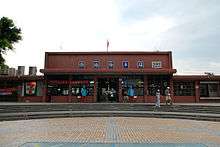
Yangmei has three railway stations (from north to south): Puxin, Yangmei and Fugang. The railway is a convenient route for commuters in Yangmei.
Road
Bus station in the district is Yangmei Bus Station of Hsinchu Bus. Yangmei is served by National Highway No. 1. Generally, it is about 50 minutes driving time to Taipei City. Provincial Highway No. 1 also serve the town, so that the transportation system is convenient for travelers.
Notable natives
- Pu Tze-chun, Deputy Minister of National Defense (2017-2018)
See also
| Wikimedia Commons has media related to Yangmei District, Taoyuan. |
References
- ↑ "History". Yangmei Township Office. Retrieved 2010-06-28.
- ↑ http://www.tycg.gov.tw/site/index.aspx?site_id=123&site_content_sn=561
City seat: Taoyuan District | ||
| Districts |  | |
| Mountain indigenous district | ||