Magong


Magong, formerly romanized as Makung, is a county-administered city and seat of Penghu, Taiwan.
Name
The settlement's temple honoring the Chinese sea goddess Mazu, the deified form of the medieval Fujianese shamaness Lin Moniang, is usually accounted the oldest in all of Taiwan and Penghu.[1] The town was originally named Makeng (Chinese: 媽宮; Pe̍h-ōe-jī: Má-keng; literally: "mother's palace") but was changed to Makō (馬公) during Japanese rule in 1920, and was the center of the Mako Guard District.
After 1945, the Wade-Giles romanization Makung was used. Taiwan officially adopted Hanyu Pinyin in 2009, leading to the romanization Magong.
History
Qing Dynasty
The island's Mazu temple was erected in the late 16th or early 17th century. The city Magong'ao began to grow around 1887, during the Qing Empire's Guangxu Era.
Japanese Empire
Under Japanese rule, the settlement was renamed Makō and organized as a subprefecture of Hōko. The area was a major base of the Imperial Japanese Navy. It was an embarkation point for the invasion of the Philippines during the Second World War.
Republic of China
On 25 December 1981, Makung was upgraded from an urban township to be a county-controlled city.
Administration

Magong City contains 33 municipal villages (里 li):
- (Romanizations are in Hanyu Pinyin)
- Fuxing (復興里)
- Chang'an (長安里)
- Zhongyang (中央里)
- Qiming (啟明里)
- Chongqing (重慶里)
- Zhongxing (中興里)
- Guangfu (光復里)
- Guangming (光明里)
- Guangrong (光榮里)
- Chaoyang (朝陽里)
- Yangming (陽明里)
- Chongguang (重光里)
- Xiwei (西衛里)
- Xiwen (西文里)
- Dongwen (東文里)
- Anshan (案山里)
- Guanghua (光華里)
- Qianliao (前寮里)
- Shiquan (石泉里)
- Caiyuan (菜園里)
- Dongwei (東衛里)
- Anzhe (安宅里)
- Xingren (興仁里)
- Wukan (烏崁里)
- Tiexian (鐵線里)
- Suogang (鎖港里)
- Shanshui (山水里)
- Wude (五德里)
- Jing'an (井垵里)
- Shili (時里奇)
- Fenggui (風櫃里)
- Hujing (虎井里)
- Tongpan (桶盤里)
Government institutions
Education
Energy

The city is powered by the Hujing Power Plant located at Table Island.
Climate
| Climate data for Magong City(1981 to 2010) | |||||||||||||
|---|---|---|---|---|---|---|---|---|---|---|---|---|---|
| Month | Jan | Feb | Mar | Apr | May | Jun | Jul | Aug | Sep | Oct | Nov | Dec | Year |
| Record high °C (°F) | 25.5 (77.9) |
27.8 (82) |
30.1 (86.2) |
35.3 (95.5) |
38.9 (102) |
39.5 (103.1) |
40.0 (104) |
39.8 (103.6) |
39.2 (102.6) |
37.6 (99.7) |
34.4 (93.9) |
30.0 (86) |
40 (104) |
| Average high °C (°F) | 19.3 (66.7) |
19.6 (67.3) |
22.4 (72.3) |
26.0 (78.8) |
28.8 (83.8) |
30.6 (87.1) |
32.0 (89.6) |
31.8 (89.2) |
30.7 (87.3) |
28.1 (82.6) |
24.8 (76.6) |
21.1 (70) |
26.3 (79.3) |
| Average low °C (°F) | 15.4 (59.7) |
15.4 (59.7) |
17.4 (63.3) |
20.9 (69.6) |
23.7 (74.7) |
25.6 (78.1) |
26.6 (79.9) |
26.5 (79.7) |
25.9 (78.6) |
23.9 (75) |
20.9 (69.6) |
17.4 (63.3) |
21.6 (70.9) |
| Record low °C (°F) | 4.4 (39.9) |
5.3 (41.5) |
8.2 (46.8) |
11.1 (52) |
15.4 (59.7) |
20.3 (68.5) |
22.7 (72.9) |
22.6 (72.7) |
21.8 (71.2) |
19.6 (67.3) |
14.3 (57.7) |
7.1 (44.8) |
4.4 (39.9) |
| Average precipitation mm (inches) | 21.9 (0.862) |
50.2 (1.976) |
52.9 (2.083) |
92.4 (3.638) |
123.2 (4.85) |
164.1 (6.461) |
131.6 (5.181) |
170.8 (6.724) |
74.2 (2.921) |
26.1 (1.028) |
20.1 (0.791) |
23.5 (0.925) |
951.0 (37.441) |
| Average relative humidity (%) | 80.5 | 82.4 | 83.1 | 83.4 | 84.5 | 86.6 | 85.1 | 85.5 | 81.2 | 78.1 | 78.0 | 78.7 | 82.3 |
| Mean monthly sunshine hours | 112.9 | 96.7 | 124.7 | 157.2 | 172.5 | 199.6 | 260.8 | 240.1 | 225.3 | 183.9 | 131.1 | 117.3 | 2,022.1 |
| Source: [2] | |||||||||||||
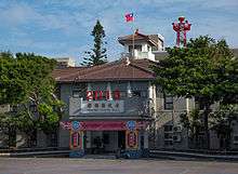
Tourist attractions
Transportation
It contains the domestic Magong Airport and Magong Harbor.
Notable natives
- Chang Yu-sheng, former singer, composer and producer
References
- ↑ "History". Magong City Office. Archived from the original on 2014-04-08.
- ↑ "中央氣象局". Archived from the original on 2009-03-18. Retrieved 2009-03-17.
External links
| Wikimedia Commons has media related to Magong City, Penghu County. |
- Magong City Office, Penghu County (in English)
- Magong Airport WebSite (in English)
| Kaohsiung | 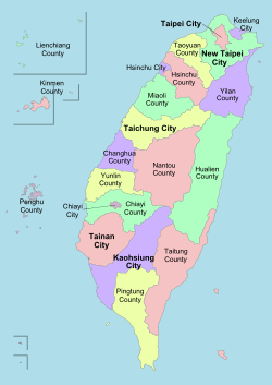 | |
|---|---|---|
| Kinmen | ||
| Lienchiang1 | ||
| Penghu | ||
| Pingtung | ||
| Taitung | ||
| Yilan | ||
1 Lienchiang County commonly known as Matsu. 2Diaoyutai Islands are controlled by Japan, (called Senkaku Islands). 3Seat of the outlying islands' counties | ||