Dali District
| Dali 大里區 | |
|---|---|
| District | |
| Dali District | |
 | |
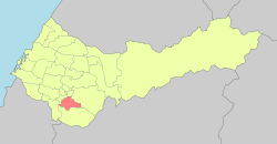 Location in Taichung | |
| Country | Taiwan |
| Special municipality | Taichung |
| Area | |
| • Total | 28.88 km2 (11.15 sq mi) |
| Population (January 2016) | |
| • Total | 208,571 people |
| Time zone | UTC+8 |
| Website | http://www.dali.taichung.gov.tw/ |
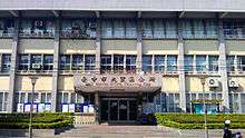
Dali District office
Dali District (Chinese: 大里區; pinyin: Dàlǐ Qū) is an inner city district in Taichung, Taiwan.
Name
The name "Dali" originates from Tai-li-khit (Chinese: 大里杙; Pe̍h-ōe-jī: Tāi-lí-khi̍t), where Tai-li refers to the Hoanya aborigines and khit refers to a bamboo raft's toon.
History
Dali used to be a county-controlled city of Taichung County from 1 November 1993 until 25 December 2010, when it became a district.
Administrative divisions
Tunghu, Xihu, Dali, Xinli, Guoguang, Shuwang, Xiangxing, Neixin, Zhongxin, Tungsheng, Dayuan, Jiatian, Renhua, Rende, Jianmin, Tucheng, Tungxing, Daming, Yonglong, Rixin, Xirong, Zhangrong, Jincheng, Liren, Lide, Xinren and Ruicheng Village.
Education
Universities
Junior high schools
Senior high schools
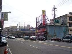
Tourist attractions
Transportation
- NH3(209)
- Provincial Highway No.3
- Provincial Highway No.63
- Provincial Highway No.74
- County route No.129
Notable residents
- Lin Shuangwen (林爽文), the leader of the Tiandihui society in Changhua and the Lin Shuangwen rebellion.
Hospital
References
| Wikimedia Commons has media related to Dali District, Taichung. |
Coordinates: 24°05′30″N 120°41′30″E / 24.09167°N 120.69167°E
City seat: Xitun | ||
| Urban area | .svg.png) | |
| Coastal area | ||
| Highland area | ||
| Mountain indigenous district | ||
Note: Although Hanyu Pinyin is the national standard; Central, East, South, West, and North District uses English instead. | ||
This article is issued from
Wikipedia.
The text is licensed under Creative Commons - Attribution - Sharealike.
Additional terms may apply for the media files.