Provinces of Vietnam
 |
|---|
| This article is part of a series on the politics and government of Vietnam |
|
Ideology |
|
|
|
Legislative |
|
Executive |
|
|
Military
|
|
| Administrative Units of Vietnam |
|---|
| First Tier |
|
| Second Tier |
|
| Third Tier |
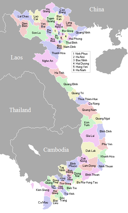
On the First Tier, Vietnam is divided into 58 provinces (Vietnamese: tỉnh) and 5 municipalities (Vietnamese: thành phố trực thuộc trung ương). Municipalities are the highest-ranked cities in Vietnam.[1] Municipality are centrally-controlled cities and have special status equal to the provinces.
The provinces are divided into Provincial Cities, Towns and Rural Districts as the Second Tier units. At the Third Tier, Provincial City and Town is divided into Ward and Commune, while Rural District is divided into Townships (thị trấn) and Communes.
Governance
People's Council
Vietnamese provinces are controlled by a People's Council (Hội Đồng Nhân Dân), elected by the inhabitants. The number of councilors varies from province to province, depending on the population of that province. The People's Council appoints a People's Committee, which acts as the executive arm of the provincial government. This arrangement is a somewhat simplified version of the situation in Vietnam's national government. Provincial governments are expected to be subordinate to the central government.
People's Committee
The People's Committee (Uỷ Ban Nhân Dân) is, as mentioned previously, the executive arm at provincial level, and is responsible for formulating and implementing policy. It may be thought of as the equivalent of a cabinet. The People's Committee will have a Chairman and a Vice-Chairman, and between nine and eleven ordinary members.
People's Court
The People's Court (Tòa án Nhân dân) is the judiciary branch at provincial level and responsible for judiciary trials. The People's Court is headed by a Chief Judge.
List and statistics

According to the census results of April 1, 2009, the population of Vietnam is 85,789,573 people. The most populous top-level administrative unit in Vietnam is Hồ Chí Minh City, one of the five centrally governed cities. It has 7,123,340 people living within its official boundaries. The second most populous administrative unit is the recently expanded Hà Nội with 6,448,837 people. Prior to the expansion of the capital city, this rank belonged to Thanh Hóa with 3,400,239 people. The least populous is Bắc Kạn, a mountainous province in the remote northeast with 294,660 people.[2]
In land area, the largest province is Nghệ An, which runs from the city of Vinh up the wide Sông Cả valley. The smallest is Bắc Ninh, located in the populous Red River Delta region.
The following is a table of Vietnam's provinces broken down by population and area, April 1, 2009.[3]
| Province/City | Capital/Administrative center | Area (km²) [3] |
Population [3] |
Density (/km²) [3] |
% Urban [3] |
HDI (2012) [4] |
GDP per capita (2011 PPP US$)[4] |
Region |
|---|---|---|---|---|---|---|---|---|
| Bắc Giang Province | Bắc Giang | 3,827.4 | 1,554,131 | 406.1 | 9.4 | 0.711 | 1,909.44 | Northeast |
| Bắc Kạn Province | Bắc Kạn | 4,868.4 | 293,826 | 60.4 | 16.1 | 0.685 | 1,766.68 | Northeast |
| Cao Bằng Province | Cao Bằng | 6,724.6 | 507,183 | 75.4 | 16.9 | 0.653 | 1,564.27 | Northeast |
| Hà Giang Province | Hà Giang | 7,945.8 | 724,537 | 91.2 | 11.6 | 0.586 | 1,083.72 | Northeast |
| Lạng Sơn Province | Lạng Sơn | 8,331.2 | 732,515 | 87.9 | 19.2 | 0.707 | 2,201.98 | Northeast |
| Phú Thọ Province | Việt Trì | 3,528.4 | 1,316,389 | 373.1 | 15.8 | 0.715 | 1,916.23 | Northeast |
| Quảng Ninh Province | Hạ Long | 6,099.0 | 1,144,988 | 187.7 | 51.9 | 0.784 | 7,834.55 | Northeast |
| Thái Nguyên Province | Thái Nguyên | 3,546.6 | 1,123,116 | 316.7 | 25.6 | 0.741 | 2,547.11 | Northeast |
| Tuyên Quang Province | Tuyên Quang | 5,870.4 | 724,821 | 123.5 | 13.0 | 0.699 | 1,948.18 | Northeast |
| Lào Cai Province | Lào Cai | 6,383.9 | 614,595 | 96.3 | 21.0 | 0.670 | 2,767.55 | Northeast |
| Yên Bái Province | Yên Bái | 6,899.5 | 740,397 | 107.3 | 18.8 | 0.657 | 1,845.51 | Northeast |
| Điện Biên Province | Điện Biên Phủ | 9,562.5 | 490,306 | 51.3 | 15.0 | 0.611 | 1,589.03 | Northwest |
| Hòa Bình Province | Hòa Bình | 4,684.2 | 785,217 | 167.6 | 15.0 | 0.715 | 2,343.13 | Northwest |
| Lai Châu Province | Lai Châu | 9,112.3 | 370,502 | 40.7 | 14.2 | 0.560 | 1,081.84 | Northwest |
| Sơn La Province | Sơn La | 14,174.4 | 1,076,055 | 75.9 | 13.8 | 0.634 | 1,773.90 | Northwest |
| Bắc Ninh Province | Bắc Ninh | 823.1 | 1,024,472 | 1,244.7 | 23.5 | 0.771 | 4,451.41 | Red River Delta |
| Hà Nam Province | Phủ Lý | 859.7 | 784,045 | 912.0 | 9.5 | 0.724 | 2,131.93 | Red River Delta |
| Hải Dương Province | Hải Dương | 1,652.8 | 1,705,059 | 1,031.6 | 19.0 | 0.746 | 2,513.92 | Red River Delta |
| Hưng Yên Province | Hưng Yên | 923.5 | 1,127,903 | 1,221.3 | 12.1 | 0.743 | 2,503.79 | Red River Delta |
| Nam Định Province | Nam Định | 1,650.8 | 1,828,111 | 1,107.4 | 17.6 | 0.726 | 1,904.97 | Red River Delta |
| Ninh Bình Province | Ninh Bình | 1,392.4 | 898,999 | 645.6 | 17.9 | 0.733 | 2,478.79 | Red River Delta |
| Thái Bình Province | Thái Bình | 1,546.5 | 1,781,842 | 1,152.1 | 9.7 | 0.738 | 2,090.86 | Red River Delta |
| Vĩnh Phúc Province | Vĩnh Yên | 1,373.2 | 999,786 | 728.1 | 22.4 | 0.764 | 3,990.61 | Red River Delta |
| Hà Nội City | Hoàn Kiếm District | 3,119.0 | 7,331,909 | 2,068.6 | 41.0 | 0.794 | 3,923.21 | Red River Delta |
| Hải Phòng City | Hồng Bàng District | 1,520.7 | 1,976,173 | 1,208.1 | 46.1 | 0.773 | 3,849.18 | Red River Delta |
| Hà Tĩnh Province | Hà Tĩnh | 5990.6 | 1,227,038 | 203.6 | 14.9 | 0.725 | 2,117.32 | North Central Coast |
| Nghệ An Province | Vinh | 16,498.5 | 2,912,041 | 176.5 | 12.9 | 0.715 | 2,379.59 | North Central Coast |
| Quảng Bình Province | Đồng Hới | 8,065.3 | 844,893 | 104.8 | 15.0 | 0.716 | 2,203.01 | North Central Coast |
| Quảng Trị Province | Đông Hà | 4,760.1 | 598,324 | 125.7 | 27.4 | 0.696 | 2,672.10 | North Central Coast |
| Thanh Hóa Province | Thanh Hóa | 11,136.3 | 3,400,595 | 305.4 | 10.4 | 0.716 | 2,434.69 | North Central Coast |
| Thừa Thiên–Huế Province | Huế | 5,065.3 | 1,087,420 | 214.7 | 36.0 | 0.735 | 3,072.58 | North Central Coast |
| Đắk Lắk Province | Buôn Ma Thuột | 13,139.2 | 1,733,624 | 131.9 | 24.0 | 0.708 | 2,555.78 | Central Highlands |
| Đắk Nông Province | Gia Nghĩa | 6,516.9 | 489,382 | 75.1 | 14.7 | 0.710 | 3,000.70 | Central Highlands |
| Gia Lai Province | Pleiku | 15,536.9 | 1,274,412 | 82.0 | 28.6 | 0.689 | 3,023.20 | Central Highlands |
| Kon Tum Province | Kon Tum | 9,690.5 | 430,133 | 44.4 | 33.5 | 0.656 | 2,075.42 | Central Highlands |
| Lâm Đồng Province | Đà Lạt | 9,776.1 | 1,187,574 | 121.5 | 37.8 | 0.735 | 3,331.80 | Central Highlands |
| Bình Định Province | Qui Nhơn | 6,039.6 | 1,486,465 | 246.1 | 27.7 | 0.742 | 3,089.10 | South Central Coast |
| Bình Thuận Province | Phan Thiết | 7,836.9 | 1,167,023 | 148.9 | 39.3 | 0.732 | 3,090.17 | South Central Coast |
| Khánh Hòa Province | Nha Trang | 5,217.6 | 1,157,604 | 221.9 | 39.9 | 0.752 | 4,180.68 | South Central Coast |
| Ninh Thuận Province | Phan Rang–Tháp Chàm | 3,363.1 | 564,993 | 168.0 | 36.1 | 0.695 | 2,402.34 | South Central Coast |
| Phú Yên Province | Tuy Hòa | 5,060.6 | 862,231 | 170.4 | 21.8 | 0.728 | 2,541.80 | South Central Coast |
| Quảng Nam Province | Tam Kỳ | 10,438.3 | 1,422,319 | 136.3 | 18.6 | 0.745 | 3,192.34 | South Central Coast |
| Quảng Ngãi Province | Quảng Ngãi | 5,152.7 | 1,216,773 | 236.1 | 14.6 | 0.718 | 3,516.44 | South Central Coast |
| Đà Nẵng City | Hải Châu District | 1,257.3 | 887,435 | 705.8 | 86.9 | 0.803 | 4,811.58 | South Central Coast |
| Bà Rịa–Vũng Tàu Province | Bà Rịa | 1,989.6 | 996,682 | 500.9 | 49.9 | 0.901 | 36,786.39 | Southeast |
| Bình Dương Province | Thủ Dầu Một | 2,696.2 | 1,481,550 | 549.5 | 29.9 | 0.751 | 3,663.54 | Southeast |
| Bình Phước Province | Đồng Xoài | 6,883.4 | 873,598 | 126.9 | 16.5 | 0.734 | 3,606.56 | Southeast |
| Đồng Nai Province | Biên Hòa | 5,903.9 | 2,486,154 | 421.1 | 33.2 | 0.763 | 3,485.16 | Southeast |
| Tây Ninh Province | Tây Ninh | 4,035.9 | 1,066,513 | 264.3 | 15.6 | 0.744 | 4,058.65 | Southeast |
| Hồ Chí Minh City | District 1 | 2,095.1 | 8,262,864 | 3,418.9 | 83.3 | 0.820 | 7,147.09 | Southeast |
| An Giang Province | Long Xuyên | 3,536.8 | 2,142,709 | 605.8 | 28.4 | 0.730 | 3,791.46 | Mekong Delta |
| Bạc Liêu Province | Bạc Liêu | 2,584.1 | 856,518 | 331.5 | 26.1 | 0.742 | 3,701.98 | Mekong Delta |
| Bến Tre Province | Bến Tre | 2,360.2 | 1,255,946 | 532.1 | 9.9 | 0.750 | 2,978.48 | Mekong Delta |
| Cà Mau Province | Cà Mau | 5,331.7 | 1,206,938 | 226.4 | 20.4 | 0.743 | 3,121.66 | Mekong Delta |
| Đồng Tháp Province | Cao Lãnh | 3,376.4 | 1,666,467 | 493.9 | 17.8 | 0.718 | 2,240.56 | Mekong Delta |
| Hậu Giang Province | Vị Thanh | 1,601.1 | 757,300 | 473.0 | 19.6 | 0.743 | 2,943.84 | Mekong Delta |
| Kiên Giang Province | Rạch Giá | 6,348.3 | 1,688,248 | 265.9 | 27.0 | 0.750 | 4,336.43 | Mekong Delta |
| Long An Province | Tân An | 4,493.8 | 1,436,066 | 319.6 | 17.4 | 0.764 | 4,012.39 | Mekong Delta |
| Sóc Trăng Province | Sóc Trăng | 3,312.3 | 1,292,853 | 390.3 | 19.4 | 0.715 | 2,835.46 | Mekong Delta |
| Tiền Giang Province | Mỹ Tho | 2,484.2 | 1,672,271 | 673.2 | 13.7 | 0.770 | 3,781.77 | Mekong Delta |
| Trà Vinh Province | Trà Vinh | 2,295.1 | 1,003,012 | 437.0 | 15.3 | 0.717 | 2,662.89 | Mekong Delta |
| Vĩnh Long Province | Vĩnh Long | 1,479.1 | 1,024,707 | 692.8 | 15.3 | 0.757 | 3,360.01 | Mekong Delta |
| Cần Thơ City | Ninh Kiều District | 1,401.6 | 1,188,435 | 847.9 | 65.9 | 0.788 | 6,260.52 | Mekong Delta |
See also List of postal codes in Vietnam
Regions
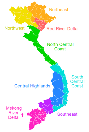
The Vietnamese government often groups the various provinces into eight regions, which are often grouped into three macro-regions: Northern, Central and Southern. These regions are not always used, and alternative classifications are possible. The regions include:
| Macro-region | Region | Provinces included | Area (km²) | Population (2015)[5] | Population density (people/ km²) |
Notes |
|---|---|---|---|---|---|---|
| Northern Vietnam (Bắc Bộ, Miền Bắc) | Northwest (Tây Bắc Bộ) | 44,301.10 | 4,446,800 | 100.37 | contains inland provinces in the west of Vietnam's northern part. Two of them are along Vietnam's border with Laos, and three border China (Dien Bien borders both China and Laos). | |
| Northeast (Đông Bắc Bộ) | 50,684.10 | 8,568,200 | 169.05 | contains most of the mountainous provinces that lie to north of the highly populated Red River lowlands. Four of them are along Vietnam's border with China. | ||
| Red River Delta (Đồng Bằng Sông Hồng) | 14,957.70 | 19,714,300 | 1,318.00 | contains the small but populous provinces along the mouth of the Red River. The Red River Delta has the smallest area but highest population and population density of all regions. It is also the only region without any land borders with neighboring countries. | ||
| Central Vietnam (Trung Bộ, Miền Trung) | North Central (Bắc Trung Bộ) | 51,455.60 | 10,472,900 | 203.53 | contains the coastal provinces in the northern half of Vietnam's narrow central part. They all stretch from the coast in the east to Laos in the west. | |
| South Central Coast (Duyên hải Nam Trung Bộ) | 44,376.80 | 9,185,000 | 206.98 | contains the coastal provinces in the southern half of Vietnam's central part. One province borders Laos. | ||
| Central Highlands (Tây Nguyên) | 54,641.00 | 5,607,900 | 102.63 | contains the mountainous provinces to the west of south-central Vietnam. There are a significant number of ethnic minorities in the region. One province is along Vietnam's border with Laos, and four border Cambodia (Kon Tum borders both Laos and Cambodia). | ||
| Southern Vietnam (Nam Bộ, Miền Nam) | Southeast (Đông Nam Bộ, Miền Đông) | 23,590.70 | 16,127,800 | 683.65 | contains those parts of lowland southern Vietnam which are north of the Mekong delta. Two provinces border Cambodia. | |
| Mekong River Delta (Đồng Bằng Sông Cửu Long) or Southwest (Tây Nam Bộ, Miền Tây) |
40,576.00 | 17,590,400 | 434.00 | is Vietnam's southernmost region, mostly containing small but populous provinces in the delta of the Mekong. It is sometimes referred to as the Southwest region (Tây Nam Bộ). Four provinces border Cambodia. |
^† Municipality (thành phố trực thuộc trung ương)
Historical provinces of Vietnam
- Ái Châu - existed during the third Chinese domination.
- An Xuyên - existed from 1956 until the Vietnamese reunification of 1976.
- Biên Hòa - existed from 1832 until the Vietnamese reunification of 1976.
- Bình Trị Thiên - administrative grouping of Quảng Bình, Quảng Trị and Thừa Thiên Provinces between 1976 and 1992.
- Bình Tuy - existed from 1956 until the Vietnamese reunification of 1976.
- Chợ Lớn - existed from 1900 until 1957.
- Chương Thiện - existed from 1961 until the Vietnamese reunification of 1976.
- Cửu Long - administrative grouping of Vĩnh Long and Vĩnh Bình Provinces between 1976 and 1992.
- Định Tường - existed from 1832 until the Vietnamese reunification of 1976.
- Gia Định - existed from 1832, became Hồ Chí Minh City following the Vietnamese reunification of 1976.
- Gò Công - existed from 1900 until the Vietnamese reunification of 1976.
- Hà Bắc - administrative grouping of Bắc Giang and Bắc Ninh Provinces between 1962 and 1996.
- Hà Tây - existed from 1965 to 1975 and 1991 until 2008, when it was merged into Hà Nội.
- Hải Hưng - administrative grouping of Hải Dương and Hưng Yên Provinces between 1968 and 1996.
- Hậu Nghĩa - existed from 1963 until the Vietnamese reunification of 1976.
- Long Khánh - existed from 1956, became Đồng Nai Province following the Vietnamese reunification of 1976.
- Minh Hải - administrative grouping of Cà Mau and Bạc Liêu Provinces between 1976 and 1996.
- Nghệ Tĩnh - administrative grouping of Nghệ An and Hà Tĩnh Provinces between 1976 and 1991.
- Phước Long - existed from 1956 until the Vietnamese reunification of 1976.
- Phước Thành - existed from 1959 until 1965.
- Phước Tuy - existed from 1956 until the Vietnamese reunification of 1976.
- Quảng Tín - existed from 1962 until the Vietnamese reunification of 1976.
- Sa Đéc - existed from 1900 until the Vietnamese reunification of 1976.
- Sông Bé - administrative grouping of Bình Dương and Bình Phước Provinces between 1976 and 1997.
- Tân An - existed from 1900 until 1956.
- Vĩnh Bình - existed from 1956 until the Vietnamese reunification of 1976.
See also
References
- ↑ ISO 3166-2:VN
- ↑ http://www.chinhphu.vn/portal/page?_pageid=439,1090462&_dad=portal&_schema=PORTAL&pers_id=1091147&item_id=33638381&p_details=1
- 1 2 3 4 5 "Report on completed census results: The 1/4/2009 Population and Housing Census". General Statistics Office Of Vietnam.
- 1 2 "Growth that works for all: Viet Nam Human Development Report 2015 on Inclusive Growth" (PDF). United Nations Development Programme. January 2016. pp. 173–174. Archived from the original (PDF) on 31 August 2018. Retrieved 31 August 2018.
- ↑ General Statistics Office (2017): Statistical Yearbook of Vietnam 2015. Statistical Publishing House, Hanoi
External links
- CityMayors.com article
- (in English) (in Chinese) Comprehensive Map of Vietnam’s Provinces c. 1890