List of transcontinental countries
This is a list of countries located on more than one continent, known as transcontinental states or intercontinental states. While there are many countries with non-contiguous overseas territories fitting this definition, only a limited number of countries have territory straddling an overland continental boundary, most commonly the line that separates Europe and Asia.
The boundary between Europe and Asia is purely conventional, and several conventions remained in use well into the 20th century. However, the now-prevalent convention, used for the purposes of this list, follows the Caucasus northern chain, the Ural River and the Ural Mountains. It has been in use by some cartographers since about 1850.[1] This convention results in several countries finding themselves almost entirely in "Asia", with a few small enclaves or districts technically in "Europe". Notwithstanding these anomalies, this list of transcontinental or intercontinental states respects the convention that Europe and Asia are full continents rather than subcontinents or component landmasses of the larger Eurasian continent.
Listed further below, separately, are countries with distant non-contiguous parts (overseas territories) on separate continents.
Contiguous boundary
Africa and Asia
The modern convention for the land boundary between Asia and Africa runs along the Isthmus of Suez and the Suez Canal in Egypt. The border continues through the Gulf of Suez, Red Sea and Gulf of Aden. In antiquity, Egypt had been considered part of Asia, with the Catabathmus Magnus escarpment taken as the boundary with Africa (Libya).
- Two of 27 governorates of Egypt lie entirely on the Asian Sinai Peninsula and two are transcontinental: Ismailia Governorate is nearly equally divided by the Suez Canal, and Suez Governorate, which is coterminous with the "transcontinental city" of Suez, has a small portion east of the Canal.
- After the Yom Kippur War of October 1973, Israel briefly became a transcontinental country as it occupied territory on the African side of the Suez Canal, in addition to the entirety of Sinai. The land was returned in 1975 per the Sinai Interim Agreement.
Asia and Europe
The conventional Europe-Asia boundary was subject to considerable variation during the 18th and 19th centuries, indicated anywhere between the Don River and the Caucasus to the south or the Ural Mountains to the east. Since the later 19th century, the Caucasus-Urals boundary has become almost universally accepted. According to this now-standard convention, the boundary follows the Aegean Sea, the Turkish Straits, the Black Sea, along the watershed of the Greater Caucasus, the northwestern portion of the Caspian Sea and along the Ural River and Ural Mountains to the Arctic Ocean.[2][3]
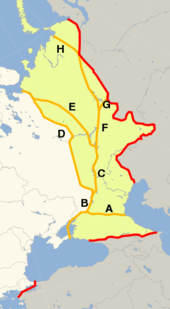
According to this convention, the Russian Federation, the Republic of Turkey, Kazakhstan, Azerbaijan and Georgia have territory both in Europe and in Asia.
- The Russian Federation includes substantial territory in Northern Asia, historically incorporated into the Tsardom of Russia in the 17th century. European Russia has a population of about 110 million, or some 75% of the country's total population, though more than 75% of Russia's territory is in Asia.
- The territory of the Republic of Turkey is predominantly in Asia, with European Turkey (East Thrace) accounting for about 11 million people, or some 14% of the country's population. The territory of Turkey is a remnant of that of the Ottoman Empire, which had replaced the transcontinental Byzantine Empire with the Sack of Constantinople in 1453. The Turkish city Istanbul (ancient Constantinople) lies on both sides of the Bosporus, making it a "transcontinental city". Çanakkale is also a Turkish city situated on two continents.
- Kazakhstan's physical, cultural, and geographic characteristics are Central Asian,[4] but its West Kazakhstan and Atyrau provinces extend on either side of the Ural River,[5] placing a population of less than one million (out of 15 million) geographically in Europe.
- Azerbaijan's Qusar, Shabran, Siazan, Khachmaz and Quba districts are north of the Greater Caucasus watershed and thus geographically in Europe, placing a population of about half a million (or ca. 5% of the country's total population) in Europe.
- Georgia is in Transcaucasia, and thus geographically in Asia, except for a small area in the upper reaches of the Terek River, corresponding to Kazbegi Municipality (population 3,800 as of 2014, ca. 0.1% of the country's population).
Non-contiguous
Asia and Europe
Europe and North America
- Greenland: Greenland is a country within the Kingdom of Denmark, fully located on the North American tectonic plate and close to the mainland, and is considered to be geographically part of North America. Although it is politically associated with Europe and internationally represented by a European country (including in the Council of Europe), it is autonomous. Historically and ethnically, its native population is of American tradition, although it also shares cultural links with other native peoples bordering the Arctic Sea in Northern Europe and Asia (today in Norway, Sweden, Finland and Russia), as well as in North America (Alaska in the U.S., Northwest Territories and Nunavut in Canada). Greenland was part of Danish territory and within the territory of the European Union, but voted for more autonomy and is now excluded from Union.
- Portugal: Continental Portugal is in Europe, while the Azores archipelago (also associated with Europe) has two islands (Corvo and Flores) that are part of the North American plate. This might make Portugal a "tricontinental country" geologically (with Madeira on the African plate) except that continents, as already noted, are not defined by tectonic plates.
Europe and South America
- The Netherlands: Though most of the Kingdom of the Netherlands' land-mass is in Europe, it also includes six island territories in the Lesser Antilles archipelago of the Caribbean Sea: the Dutch Caribbean. Since the dissolution of the Dutch Antilles in 2010, the sovereign Kingdom of the Netherlands has been administratively divided into four non-sovereign constituent "countries": Aruba, Curaçao, Sint Maarten and The Netherlands — the last of which includes the islands of Bonaire, St. Eustatius and Saba (collectively known as the BES islands or the Caribbean Netherlands) in the Caribbean area as "special municipalities", making it a non-sovereign transcontinental country within the kingdom.
Europe, North America, South America, Oceania, Africa and Antarctic
- France: Metropolitan France is in Europe, while the five Overseas Departments and six Overseas Collectivities are in other continents. Guadeloupe, Martinique, Saint-Martin, Saint-Barthélemy, and Saint-Pierre and Miquelon are in North America, French Guiana is in South America, Mayotte and Réunion are in Africa, and New Caledonia, French Polynesia, and Wallis and Futuna are in Oceania. These Overseas Departments and Collectivities are integral parts of France, as are the uninhabited Clipperton Island in North America and French Southern and Antarctic Lands which include Scattered Islands in Africa, St. Paul and Amsterdam islands on the Australian Plate, and Kerguelen Islands, Crozet Island and Adélie Land in Antarctic. French sovereignty on Adélie Land is under Antarctic Treaty System .
Africa and Europe
- Italy: Italy has a number of small islands south of Sicily which, geographically can be considered part of the African continent, due to their proximity to Tunisia. The closest land to Pantelleria and the Pelagie Islands (Lampedusa, Linosa and Lampione) is Tunisia on the African mainland. Nevertheless, Pantelleria and Linosa are considered part of Europe, Lampedusa and Lampione part of Africa.
- Portugal: Continental Portugal is in Europe, while the archipelago of Madeira, an autonomous region of Portugal (including Porto Santo Island, the Desertas Islands and the Savage Islands), is associated with Africa. If we consider that the Azores autonomous region of Portugal has two islands (Flores and Corvo) that are part of North American tectonic plate (see Europe and North America section above), Portugal would be a transcontinental country geologically except for the fact these plates are not defined as continents.
- Spain: Although its mainland is in Europe, Spain has territory including two provinces and two autonomous cities in Africa. Close to 5% of Spain's population live on the African continent. Territories include the Canary Islands in the Atlantic, the cities of Ceuta and Melilla on mainland North Africa and its Plazas de soberanía close to those cities) that are geographically part of Africa. The Canary Islands, Ceuta and Melilla are three of the 19 autonomous communities and cities that form Spain, while the Plazas de Soberanía are under different military status. The African Mediterranean island of Isla de Alborán belongs to the transcontinental city of Almería and the transcontinental province of Almería.
Asia and Africa
- Yemen: Although mainland Yemen is in the southern Arabian Peninsula and thus part of Asia, and its Hanish Islands and Perim in the Red Sea are associated with Asia, Yemen controls the archipelago of Socotra, which lies east of the horn of Somalia and is much closer to Africa than to Asia. Socotra and the Mahra region constitute the transcontinental Mahra Governorate.
Asia and Australasia
- Australia: The Commonwealth of Australia consists of its namesake continent and island possessions associated with Oceania, Asia, and Antarctica. Its Indian Ocean island possessions of Christmas Island and the Cocos (Keeling) Islands are associated with Asia. The majority of Australia's Asian island residents have Asian ancestry and are Muslim or Buddhist.
- The Malay Archipelago which lies on the border of Melanesia and Southeast Asia. Depending on the interpretation of the border, the Philippines, Malaysia and Indonesia, and Papua New Guinea can be considered transcontinental countries and East Timor, Brunei and Singapore can be on either side. Papua New Guinea anthropologically is a part of Melanesia and is sometimes included in the Malay Archipelago. It is an observer in ASEAN and has contemplated full membership.[6]
North America and Asia
- United States: While the territory of the United States lies overwhelmingly in North America, it includes the state of Hawaii in Oceania as well as other Oceanian island possessions and Alaskan islands on NE Asia's continental shelf.
North and South America
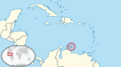
- Aruba, Bonaire, Curaçao and Trinidad and Tobago: The sea islands division of South America and North America is complicated. All Caribbean islands are often labeled as North American, but the Kingdom of the Netherlands countries of Aruba and Curaçao, and the Dutch special municipality of Bonaire lie on the continental shelf of South America, and can be considered South American as well. What complicates it even further is that the islands of Trinidad and Tobago lie on two continental shelves. The southern half of Trinidad lies in South America and the northern half of Trinidad, and Tobago, lie on the Caribbean plate. All these islands have closer cultural ties with North America.
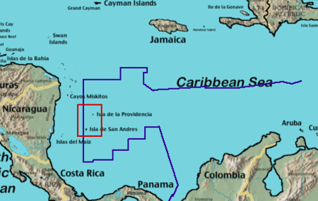
- Colombia: Mainland Colombia is in northwestern South America and Malpelo Island in the Pacific Ocean is also associated with South America, but the nation also controls the San Andrés and Providencia archipelago, 640 kilometres (400 mi) WNW of Colombia's Caribbean coast, near the Caribbean coast of Nicaragua. This archipelago is coterminous with the department of the same name.
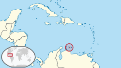
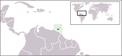
- Venezuela: Mainland Venezuela is in South America, but Isla Aves are geographically North American. Isla Aves is one of the federal dependencies of Venezuela under the administration of the Ministry of Popular Power for Interior, Justice and Peace.
North American Caribbean islands belonging to South American countries:
South American Caribbean islands:
Other examples
- Chile is mostly on the South American mainland and includes the Oceanian islands of Easter Island and Sala y Gómez Island. They and the outlying South American Juan Fernández Islands and Desventuradas Islands are part of the Valparaíso Region.
- The Danish Realm includes Denmark as well as the North American island of Greenland and the Faroe Islands associated with Europe. Greenland was integrated into the Danish Realm in 1953 and home rule was granted in 1979.
- The Kingdom of the Netherlands includes the constituent countries of Aruba, Curaçao, and Sint Maarten. In addition, after the split of the Netherlands Antilles the Caribbean islands of Bonaire, Sint Eustatius and Saba became special municipalities incorporated into the metropolitan Netherlands.
Antarctica: claims
A number of nations claim ownership over portions of the continent of Antarctica. Some, including Argentina and Chile, consider the Antarctic land they claim to be integral parts of their national territory. Some nations also have sub-Antarctic island possessions north of 60°S latitude and thus recognized by international law under the Antarctic Treaty System, which holds in abeyance land claims south of 60°S latitude.
See also
References
- ↑ The question was treated as a "controversy" in British geographical literature until at least the 1860s, with Douglas Freshfield advocating the Caucasus crest boundary as the "best possible", citing support from various "modern geographers" (Journey in the Caucasus, Proceedings of the Royal Geographical Society, Volumes 13-14, 1869). In 1958, the Soviet Geographical Society formally recommended that the boundary between Europe and Asia be drawn in textbooks from Baydaratskaya Bay, on the Kara Sea, along the eastern foot of the Ural Mountains, then the Ural River to the Mugodzhar Hills, the Emba River, and the Kuma–Manych Depression (i.e. passing well north of the Caucasus); "Do we live in Europe or in Asia?" (in Russian). ; Orlenok V. (1998). "Physical Geography" (in Russian). Archived from the original on 2011-10-16. . Nevertheless, most Soviet-era geographers continued to favour the boundary along the Caucasus crest. (E. M. Moores, R. W. Fairbridge, Encyclopedia of European and Asian regional geology, Springer, 1997, ISBN 978-0-412-74040-4, p. 34: "most Soviet geographers took the watershed of the Main Range of the Greater Caucasus as the boundary between Europe and Asia.")
- ↑ National Geographic Atlas of the World (9th ed.). Washington, DC: National Geographic. 2011. ISBN 978-1-4262-0634-4. "Europe" (plate 59); "Asia" (plate 74): "A commonly accepted division between Asia and Europe ... is formed by the Ural Mountains, Ural River, Caspian Sea, Caucasus Mountains, and the Black Sea with its outlets, the Bosporus and Dardanelles."
- ↑ World Factbook. Washington, DC: Central Intelligence Agency.
- ↑ Encyclopædia Britannica, Kazakhstan, Retrieved: 8 May 2016
- ↑ World Factbook. Washington, D.C.: Central Intelligence Agency. Kazakhstan: Geography
- ↑ "Papua New Guinea asks RP support for Asean membership bid". GMA News. Retrieved 15 July 2014.
External links
- Transcontinental states according to World Gazetteer at Archive.is (archived 2012-12-18)