Tuy Hòa
| Tuy Hòa Thành phố Tuy Hòa | |
|---|---|
| Provincial city (Class-2) | |
 Tuy Hòa Location of Tuy Hòa in Vietnam | |
| Coordinates: 13°04′55″N 109°17′42″E / 13.08194°N 109.29500°E | |
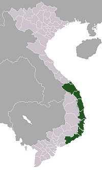
| Country |
|
| Province | Phú Yên |
| Area | |
| • Total | 107 km2 (41 sq mi) |
| Population (2012) | |
| • Total | 202,030 |
| • Density | 1,888.1/km2 (4,890/sq mi) |
| Time zone | UTC + 7 |
Tuy Hòa (![]()
The city is formulated mainly from alluvial of the downstream of Đà Rằng River. There are two mountains in the center of the city: Chóp Chài Mountain and Nhạn Mountain.

Đà Rằng River and Nhan Mountain create a poetic landscape. There is a Champa Temple on the top of Nhạn Mountain. Standing at this place, visitors easily enjoy a full view of Tuy Hoa city.
Infrastructure
Transportation
By air
The city is served by Dong Tac Airport which lies south of Tuy Hòa.
By land
Tuy Hòa Railway Station is a stop on the North-South Railway. National Route 1A runs through the city, providing road connections to Hanoi in the north and Ho Chi Minh City in the south.
Gallery
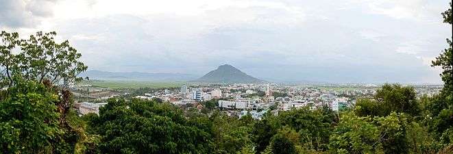 Tuy Hoa city view from Champa Temple in Nhan mountain
 The city night
Climate
| Climate data for Tuy Hòa | |||||||||||||
|---|---|---|---|---|---|---|---|---|---|---|---|---|---|
| Month | Jan | Feb | Mar | Apr | May | Jun | Jul | Aug | Sep | Oct | Nov | Dec | Year |
| Record high °C (°F) | 33.7 (92.7) |
36.5 (97.7) |
36.3 (97.3) |
39.2 (102.6) |
40.5 (104.9) |
39.4 (102.9) |
38.3 (100.9) |
38.4 (101.1) |
38.4 (101.1) |
36.0 (96.8) |
34.5 (94.1) |
33.1 (91.6) |
40.5 (104.9) |
| Average high °C (°F) | 26.5 (79.7) |
27.7 (81.9) |
29.8 (85.6) |
31.9 (89.4) |
33.9 (93) |
34.1 (93.4) |
34.2 (93.6) |
33.9 (93) |
32.3 (90.1) |
29.6 (85.3) |
27.8 (82) |
26.4 (79.5) |
30.7 (87.3) |
| Daily mean °C (°F) | 23.1 (73.6) |
23.8 (74.8) |
25.3 (77.5) |
27.2 (81) |
28.8 (83.8) |
29.3 (84.7) |
29.0 (84.2) |
28.7 (83.7) |
27.7 (81.9) |
26.3 (79.3) |
25.2 (77.4) |
23.8 (74.8) |
26.5 (79.7) |
| Average low °C (°F) | 21.1 (70) |
21.3 (70.3) |
22.5 (72.5) |
24.0 (75.2) |
25.4 (77.7) |
25.9 (78.6) |
25.6 (78.1) |
25.5 (77.9) |
24.7 (76.5) |
24.0 (75.2) |
23.3 (73.9) |
21.8 (71.2) |
23.8 (74.8) |
| Record low °C (°F) | 15.2 (59.4) |
16.1 (61) |
16.4 (61.5) |
18.8 (65.8) |
21.4 (70.5) |
21.9 (71.4) |
21.7 (71.1) |
22.0 (71.6) |
20.9 (69.6) |
19.1 (66.4) |
17.7 (63.9) |
15.2 (59.4) |
15.2 (59.4) |
| Average precipitation mm (inches) | 57 (2.24) |
20 (0.79) |
25 (0.98) |
34 (1.34) |
77 (3.03) |
56 (2.2) |
45 (1.77) |
52 (2.05) |
234 (9.21) |
579 (22.8) |
454 (17.87) |
194 (7.64) |
1,826 (71.89) |
| Average precipitation days | 11.5 | 5.3 | 3.8 | 4.1 | 8.5 | 7.6 | 6.6 | 9.0 | 16.0 | 20.2 | 20.4 | 17.5 | 130.6 |
| Average relative humidity (%) | 84.1 | 84.5 | 83.7 | 82.3 | 78.8 | 74.9 | 74.4 | 75.7 | 81.0 | 86.0 | 86.2 | 84.8 | 81.4 |
| Mean monthly sunshine hours | 159 | 192 | 258 | 269 | 275 | 237 | 241 | 228 | 201 | 165 | 122 | 121 | 2,467 |
| Source: Vietnam Institute for Building Science and Technology[1] | |||||||||||||
References
- ↑ "Vietnam Building Code Natural Physical & Climatic Data for Construction" (PDF). Vietnam Institute for Building Science and Technology. Archived from the original (PDF) on 22 July 2018. Retrieved 20 July 2018.
| Da Nang city※ |
|  |
|---|---|---|
| Bình Định Province | ||
| Bình Thuận Province | ||
| Khánh Hòa Province |
| |
| Ninh Thuận Province | ||
| Phú Yên Province | ||
| Quảng Nam Province | ||
| Quảng Ngãi Province | ||
※ denotes provincial seat. / § Sovereignty over Hoàng Sa Island & Trường Sa Island is disputed as 24 October 2018. | ||