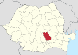
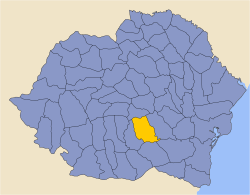
Prahova County
| Prahova County Județul Prahova | ||
|---|---|---|
| County | ||
| ||
 | ||
| Coordinates: 45°06′N 26°01′E / 45.1°N 26.02°ECoordinates: 45°06′N 26°01′E / 45.1°N 26.02°E | ||
| Country | Romania | |
| Development region | Sud | |
| Historical region | Muntenia | |
| Capital | Ploiești | |
| Area | ||
| • Total | 4,716 km2 (1,821 sq mi) | |
| Area rank | 33rd | |
| Population (2011) | ||
| • Total | 762,886 | |
| • Rank | 3rd | |
| • Density | 160/km2 (420/sq mi) | |
| Telephone code | (+40) 244 or (+40) 344[1] | |
| ISO 3166 code | RO-PH | |
| Website |
County Council Prefecture | |
Prahova County (Romanian pronunciation: [ˈprahova]) is a county (județ) of Romania, in the historical region Muntenia, with the capital city at Ploiești.
Demographics
In 2011, it had a population of 762,886 and the population density was 161/km². It is Romania's third most populated county (after the Municipality of Bucharest and Iași County),[2] having a population density double that of the country's mean.
| Year | County population[4] |
|---|---|
| 1948 | 557,776 |
| 1956 | |
| 1966 | |
| 1977 | |
| 1992 | |
| 2002 | |
| 2011 |
The county received an inflow of population who have moved here due to the industrial development.
Geography
This county has a total area of 4,716 km².
The relief is split in approximately equal parts between the mountains, the hills and the plain. In the North side there are mountains from the southern end of the Eastern Carpathians - the Curvature Carpathians group; and the Bucegi Mountains the Eastern end of the Southern Carpathians group. The two groups are separated by the Prahova River Valley.
The south side of the county is a plain, on the North West side of the Romanian Plain.
The main river is the eponymous Prahova River. It flows from the mountains, through the Prahova Valley collecting many other rivers - the Doftana River, the Teleajen River and others.
Neighbours
- Buzău County in the East.
- Dâmbovița County in the West.
- Brașov County in the North.
- Ialomița County and Ilfov County in the South.
Economy
The area contains the main oil reserves in Romania, with a longstanding tradition in extracting and refining the oil. The county is heavily industrialised, more than 115,000 people being involved in industrial activities. It contributes to over 8% of the country's industrial production. Some of the biggest international corporations like Coca-Cola, Unilever, InBev, Johnson Controls, Cameron, Weatherford, Michelin, Timken and others have invested heavily in the recent years.
The predominant industries in the county are:
- Oil industry - almost 50% of the county's industrial production.
- Oil extracting equipment.
- Chemical industry.
- Rubber industry.
- Mechanical components industry.
- Food and beverages industry.
- Textile industry.
Agriculture is also developed - in the southern part mainly extensive agriculture and the hills area is well suited for wines and fruit orchards. In total it realises about 3% of the country's agricultural production.
Tourism
The Prahova Valley is one of the areas with the highest tourist potential in the country having one of the best tourism facilities in Romania.
The main tourist destinations are:
- On the Prahova Valley:
- The Sinaia Resort.
- The Bușteni Resort.
- The Azuga Resort.
- The Bucegi Mountains.
- On the Teleajen River Valley:
- The Vălenii de Munte Resort.
- Cheia.
- Slănic.
- The Zăganul Mountains
- The Ciucaș Mountains.
- On the Doftana River Valley:
- The Teleaga Resort.
- Valea Doftanei.
- The Gârbova Mountains.
- The city of Ploiești.
- The city of Câmpina.
Politics
The Prahova County Council, elected at the 2016 local government elections, is made up of 37 counselors, with the following party composition:[5]
| Party | Seats | Current County Council | ||||||||||||||||
|---|---|---|---|---|---|---|---|---|---|---|---|---|---|---|---|---|---|---|
| Social Democratic Party | 16 | |||||||||||||||||
| National Liberal Party | 15 | |||||||||||||||||
| Alliance of Liberals and Democrats | 4 | |||||||||||||||||
| People's Movement Party | 2 | |||||||||||||||||
Administrative divisions
Prahova County has 2 municipalities, 12 towns and 90 communes

Municipalities
Towns
Communes
- Adunați
- Albești-Paleologu
- Aluniș
- Apostolache
- Ariceștii Rahtivani
- Ariceștii Zeletin
- Baba Ana
- Balta Doamnei
- Bălțești
- Bănești
- Bărcănești
- Bătrâni
- Berceni
- Bertea
- Blejoi
- Boldești-Grădiștea
- Brazi
- Brebu
- Bucov
- Călugăreni
- Cărbunești
- Ceptura
- Cerașu
- Chiojdeanca
- Ciorani
- Cocorăștii Mislii
- Cocorăștii Colț
- Colceag
- Cornu
- Cosminele
- Drăgănești
- Drajna
- Dumbrava
- Dumbrăvești
- Filipeștii de Pădure
- Filipeștii de Târg
- Fântânele
- Florești
- Fulga
- Gherghița
- Gorgota
- Gornet
- Gornet-Cricov
- Gura Vadului
- Gura Vitioarei
- Iordăcheanu
- Izvoarele
- Jugureni
- Lapoș
- Lipănești
- Măgurele
- Măgureni
- Măneciu
- Mănești
- Olari
- Păcureți
- Păulești
- Plopu
- Podenii Noi
- Poiana Câmpina
- Poienarii Burchii
- Posești
- Predeal-Sărari
- Provița de Jos
- Provița de Sus
- Puchenii Mari
- Râfov
- Salcia
- Sălciile
- Scorțeni
- Secăria
- Sângeru
- Șirna
- Șoimari
- Șotrile
- Starchiojd
- Ștefești
- Surani
- Talea
- Tătaru
- Teișani
- Telega
- Tinosu
- Târgșoru Vechi
- Tomșani
- Vadu Săpat
- Valea Călugărească
- Valea Doftanei
- Vărbilău
- Vâlcănești
Historical county
| Județul Prahova | ||
|---|---|---|
| County (Județ) | ||
 The building of the Prahova County court from the interwar period, now the Ploiești Palace of Culture. | ||
| ||
 | ||
| Country |
| |
| Historic region | Muntenia | |
| Capital city (Reședință de județ) | Ploiești, then spelt Ploești | |
| Area | ||
| • Total | 5,040 km2 (1,950 sq mi) | |
| Population (1930) | ||
| • Total | 477,750 | |
| • Density | 95/km2 (250/sq mi) | |
| Time zone | UTC+2 (EET) | |
| • Summer (DST) | UTC+3 (EEST) | |
Historically, the county was located in the south central part of Greater Romania, in the central part of the historical region of Muntenia. Its capital was Ploiești (then spelt Ploești). The interwar county territory comprised a large part of the current Prahova County, except the town of Mizil and several nearby villages that were then in Buzău County. In addition to the current county's territory, the interwar county contained several communes in its western part (including Dărmănești, I.L. Caragiale, and Moreni), currently in Dâmboviţa County, and some territory northwest of Predeal, now in Braşov County.
Administration
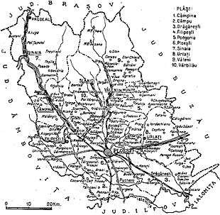
The county was originally divided into seven administrative districts (plăṣi):[6]
- Plasa Câmpina, headquartered at Câmpina
- Plasa Drăgănești, headquartered at Drăgănești
- Plasa Filipești, headquartered at Filipești
- Plasa Ploiești, headquartered at Ploești
- Plasa Sinaia, headquartered at Sinaia
- Plasa Urlați, headquartered at Urlați
- Plasa Văleni, headquartered at Văleni
Subsequently, the county established three more districts:
Population
According to the 1930 census data, the county population was 477,750 inhabitants, ethnically divided as follows: 95.0% Romanians, 1.5% Gypsies, 0.9% Jews, 0.8% Hungarians, 0.7% Germans, as well as other minorities.[7] From the religious point of view, the population was 96.0% Eastern Orthodox, 1.2% Roman Catholic, 1.0% Jewish, 0.6% Lutherans, 0.5% Greek Catholic, as well as other minorities.[8]
Urban population
In 1930, the county's urban population was 105,098 inhabitants, comprising 88.8% Romanians, 3.5% Jews, 1.9% Hungarians, 1.7% Germans, 1.4% Romanies, as well as other minorities.[7] From the religious point of view, the urban population was composed of 89.2% Eastern Orthodox, 3.6% Jewish, 3.3% Roman Catholic, 1.5% Lutheran, 1.3% Greek Catholic, 0.6% Reformed, as well as other minorities.[8]
See also
References
| Wikimedia Commons has media related to Prahova County. |
- ↑ The number used depends on the numbering system employed by the phone companies on the market.
- ↑ "Population at 20 October 2011" (in Romanian). INSSE. 5 July 2013. Retrieved 8 July 2013.
- ↑ National Institute of Statistics, "Populația după etnie" Archived 2009-08-16 at the Wayback Machine.
- ↑ National Institute of Statistics, "Populația la recensămintele din anii 1948, 1956, 1966, 1977, 1992 și 2002"
- ↑ "Mandate de CJ pe judete si competitori" (in Romanian). Biroul Electoral Central. 10 June 2016. Retrieved 16 June 2016.
- ↑ Portretul României Interbelice - Județul Prahova
- 1 2 Recensământul general al populației României din 29 decemvrie 1930, Vol. II, pag. 338-339
- 1 2 Recensământul general al populației României din 29 decemvrie 1930, Vol. II, pag. 690