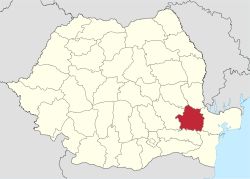
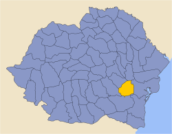
Brăila County
| Brăila County Județul Brăila | ||
|---|---|---|
| County | ||
| ||
 | ||
| Coordinates: 45°07′N 27°41′E / 45.11°N 27.68°ECoordinates: 45°07′N 27°41′E / 45.11°N 27.68°E | ||
| Country |
| |
| Development region1 | Sud-Est | |
| Historic region | Muntenia | |
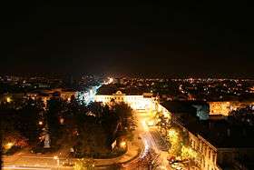
| Capital city (Reședință de județ) | Brăila | |
| Government | ||
| • Type | County Board | |
| • Prefect2 | Mihaela Marcu | |
| Area | ||
| • Total | 4,766 km2 (1,840 sq mi) | |
| Area rank | 32nd in Romania | |
| Population (2011) | ||
| • Total | 304,925 | |
| • Rank | 30th in Romania | |
| • Density | 64/km2 (170/sq mi) | |
| Time zone | UTC+2 (EET) | |
| • Summer (DST) | UTC+3 (EEST) | |
| Postal Code | 81wxyz3 | |
| Area code(s) | +40 x394 | |
| Car Plates | BR5 | |
| GDP | US$ 2.72 billion (2008) | |
| GDP/capita | US$ 7,286 (2008) | |
| Website |
County Board County Prefecture | |
|
1The developing regions of Romania have no administrative role. They were formed just to attract funds from the European Union 2 as of 2007, the Prefect is not a politician, but a public functionary. He (or she) is not allowed to be a member of a political party, and is banned to have any political activity in the first six months after the resignation (or exclusion) from the public functionary corps 3w, x, y, and z are digits that indicate the city, the street, part of the street, or even the building of the address 4x is a digit indicating the operator: 2 for the former national operator, Romtelecom, and 3 for the other ground telephone networks 5used on both the plates of the vehicles that operate only in the county limits (like utility vehicles, ATVs, etc.), and the ones used outside the county | ||

Brăila County (Romanian pronunciation: [brəˈila] (![]()
Demographics
In 2011, Brăila had a population of 304,925 and the population density was 64/km2.[1]
| Year | County population[3] |
|---|---|
| 1948 | |
| 1956 | |
| 1966 | |
| 1977 | |
| 1992 | |
| 2002 | |
| 2011 | |
Geography
This county has a total area of 4,766 km2.
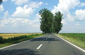
All the county lies on a flat plane: the Bărăgan Plain, one of the best areas for growing cereals in Romania.
On the east side there is the Danube, which forms an island – The Great Brăila Island surrounded by the Măcin channel, Cremenea channel and Vâlciu channel. On the northern side there is the Siret River and on the north-western side there is the Buzău River.
Neighbours
- Tulcea County in the east.
- Buzău County in the west.
- Galați County and Vrancea County in the north.
- Ialomița County and Constanța County in the south.
Economy
The agriculture is the main occupation in the county. Industry is almost entirely concentrated in the city of Brăila.
The predominant industries in the county are:
- Food industry.
- Textile industry.
- Mechanical components industry.
In Brăila there is an important harbour, once the biggest cereal harbour in Romania.
Tourism
The main tourist destinations are:
- The city of Brăila.
- The Lacu Sărat Resort.
Politics
The Brăila County Council, elected at the 2016 local government elections, is made up of 33 counselors, with the following party composition:[4]
| Party | Seats | Current County Council | ||||||||||||||
|---|---|---|---|---|---|---|---|---|---|---|---|---|---|---|---|---|
| Social Democratic Party | 14 | |||||||||||||||
| National Liberal Party | 12 | |||||||||||||||
| Alliance of Liberals and Democrats | 2 | |||||||||||||||
| People's Movement Party | 2 | |||||||||||||||
| National Democratic Party | 2 | |||||||||||||||
| Independent | 1 | |||||||||||||||
Administrative divisions

Brăila County has 1 municipality, 3 towns and 40 communes
- Communes
- Bărăganul
- Berteștii de Jos
- Bordei Verde
- Cazasu
- Chiscani
- Ciocile
- Cireșu
- Dudești
- Frecăței
- Galbenu
- Gemenele
- Grădiștea
- Gropeni
- Jirlău
- Mărașu
- Măxineni
- Mircea Vodă
- Movila Miresii
- Racovița
- Râmnicelu
- Romanu
- Roșiori
- Salcia Tudor
- Scorțaru Nou
- Siliștea
- Stăncuța
- Surdila-Găiseanca
- Surdila-Greci
- Șuțești
- Tichilești
- Traian
- Tudor Vladimirescu
- Tufești
- Ulmu
- Unirea
- Vădeni
- Victoria
- Vișani
- Viziru
- Zăvoaia
Historical county
| Județul Brăila | ||
|---|---|---|
| County (Județ) | ||
 The Brăila County prefecture and court building from the interwar period, now the engineering building of Dunărea de Jos University. | ||
| ||
 | ||
| Country |
| |
| Historic region | Muntenia | |
| Capital city (Reședință de județ) | Brăila | |
| Area | ||
| • Total | 4,286 km2 (1,655 sq mi) | |
| Population (1930) | ||
| • Total | 219,932 | |
| • Density | 51/km2 (130/sq mi) | |
| Time zone | UTC+2 (EET) | |
| • Summer (DST) | UTC+3 (EEST) | |
Historically, the county was located in the southeastern part of Greater Romania, in the northeastern part of the Muntenia region. Its territory included the portions of the current county to the east and south-east of the Buzău River. It was bordered on the west by the counties of Buzău and Râmnicu-Sărat, to the north by Covurlui County, to the east by Tulcea County, and to the south by the counties of Constanța and Ialomița.
Administration
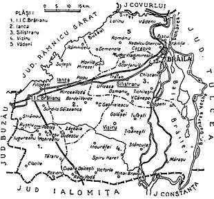
The county was originally divided administratively into four districts (plăṣi):[5]
- Plasa Călmățui, with headquarters at Făurei
- Plasa Ianca, with headquarters at Ianca
- Plasa Silistraru, with headquarters at Silistraru
- Plasa Viziru, with headquarters at Viziru
Subsequently, Plasa Călmățui, was abolished and two new districts were established in its place:
Population

According to the 1930 census data, the county population was 219,831 inhabitants, ethnically divided as follows: 89.4% Romanians, 3.1% Jews, 2.2% Greeks, 0.7% Hungarians, 0.6% Russians, as well as other minorities.[6] From the religious point of view, the population was 93.6% Eastern Orthodox, 3.3% Jewish, 1.2% Roman Catholic, as well as other minorities.[7]
Urban population
In 1930, the county's urban population was 68,347 inhabitants, comprising 75.4% Romanians, 9.7% Jews, 6.7% Greeks, 1.7% Hungarians, 1.6% Russians, as well as other minorities.[6] Mother tongues among the urban population were Romanian (82.6%), Greek (5.8%), Yiddish (4.8%), Russian (1.9%), Hungarian (1.5%), as well as other minorities. From the religious point of view, the urban population was composed of 84.4% Eastern Orthodox, 10.4% Jewish, 3.2% Roman Catholic, as well as other minorities.[7]
References
| Wikimedia Commons has media related to Brăila County. |
- ↑ "COMUNICAT DE PRESĂ : 2 februarie 2012 privind rezultatele provizorii ale Recensământului Populaţiei şi Locuinţelor – 2011" (PDF). Recensamantromania.ro. Retrieved 11 April 2018.
- ↑ National Institute of Statistics, "Populația după etnie" Archived 16 August 2009 at the Wayback Machine.
- ↑ National Institute of Statistics, "Populația la recensămintele din anii 1948, 1956, 1966, 1977, 1992 și 2002" Archived 22 September 2006 at the Wayback Machine.
- ↑ "Mandate de CJ pe judete si competitori" (in Romanian). Biroul Electoral Central. 10 June 2016. Retrieved 16 June 2016.
- ↑ Portretul României Interbelice - Județul Brăila
- 1 2 Recensământul general al populației României din 29 decemvrie 1930, Vol. II, pag. 80-81
- 1 2 Recensământul general al populației României din 29 decemvrie 1930, Vol. II, pag. 561