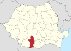
Olt County
| Olt County Județul Olt | ||
|---|---|---|
| County | ||
| ||
 | ||
| Country | Romania | |
| Development region | Sud-Vest | |
| Historical region | Wallachia | |
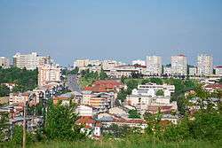
| Capital | Slatina | |
| Area | ||
| • Total | 5,498 km2 (2,123 sq mi) | |
| Area rank | 22nd | |
| Population (2011[1]) | ||
| • Total | 415,530 | |
| • Rank | 19th | |
| • Density | 76/km2 (200/sq mi) | |
| Telephone code | (+40) 249 or (+40) 349[2] | |
| ISO 3166 code | RO-OT | |
| Website |
County Council Prefecture | |
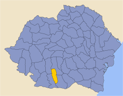
Olt County (Romanian pronunciation: [olt]) is a county (județ) of Romania on the border with Bulgaria, in the historical regions of Oltenia and Muntenia (the regions are separated by the Olt river). The capital city is Slatina.
On 24 August 2017, the Olt County Council decided to hold a local referendum on 15 October 2017 on the proposal to change the county name to "Olt-Romanați".[3] The local referendum will eventually be held on 7 October 2018, at the same time with the constitutional referendum regarding the change of the definition of the family as provided by Article 48 of the Romanian Constitution in order to outlaw same-sex marriage.[4]
Demographics
In 2011, it had a population of 415,530 and the population density was 75.57/km².
| Year | County population[6] |
|---|---|
| 1948 | 442,442 |
| 1956 | |
| 1966 | |
| 1977 | |
| 1992 | |
| 2002 | |
| 2011 |
The county is a mainly rural one, with over 60% of the population living in villages.
Geography
This county has a total area of 5,498 km².
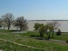
The county lies in a flat area on the Western part of the Romanian Plain. It is crossed by rivers from North to South, the main one - the Olt River giving the county its name. The Danube forms a wide valley in the South, with lots of ponds and small channels, which are flooded from time to time.
Neighbours
- Teleorman County to the East.
- Dolj County to the West.
- Argeș County and Vâlcea County to the North.
- Bulgaria to the South - Vratsa Province and Pleven Province.
Economy
The predominant industries in the county are:
- Metallurgy - aluminium and aluminium components.
- Railway equipment.
- Food and beverages industry.
- Textile industry.
- Mechanical components industry.
Agriculture is the main occupation in the county - over 58% of the population having agriculture as their main occupation. Both extensive agriculture, and small scale, vegetables and fruits, are practiced. The area is well suited for irrigations.
Tourism
The main destinations for tourists are:
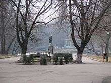
- The city of Slatina.
- Fishing on the Danube and on the Olt River.
- City of Corabia with an ancient Roman citadel, a large orthodox cathedral, Danube sunbathes, sailing and fishing.
- The town of Scornicești - the birthplace of Nicolae Ceaușescu.
Politics
The Olt County Council, elected at the 2016 local government elections, is made up of 33 counselors, with the following party composition:[7]
| Party | Seats | Current County Council | |||||||||||||||||||
|---|---|---|---|---|---|---|---|---|---|---|---|---|---|---|---|---|---|---|---|---|---|
| Social Democratic Party | 19 | ||||||||||||||||||||
| National Liberal Party | 9 | ||||||||||||||||||||
| Alliance of Liberals and Democrats | 3 | ||||||||||||||||||||
| People's Movement Party | 2 | ||||||||||||||||||||
Administrative divisions
Olt County has 2 municipalities, 6 towns and 104 communes:
- Communes
- Băbiciu
- Baldovinești
- Bălteni
- Bărăști
- Bârza
- Bobicești
- Brâncoveni
- Brastavățu
- Brebeni
- Bucinișu
- Cârlogani
- Călui
- Cezieni
- Cilieni
- Colonești
- Corbu
- Coteana
- Crâmpoia
- Cungrea
- Curtișoara
- Dăneasa
- Deveselu
- Dobrețu
- Dobrosloveni
- Dobroteasa
- Dobrun
- Drăghiceni
- Făgețelu
- Fălcoiu
- Fărcașele
- Găneasa
- Găvănești
- Gârcov
- Giuvărăști
- Ghimpețeni
- Gostavățu
- Grădinari
- Grădinile
- Grojdibodu
- Gura Padinii
- Ianca
- Iancu Jianu
- Icoana
- Ipotești
- Izbiceni
- Izvoarele
- Leleasca
- Mărunței
- Mihăești
- Milcov
- Morunglav
- Movileni
- Nicolae Titulescu
- Obârșia
- Oboga
- Oporelu
- Optași-Măgura
- Orlea
- Osica de Sus
- Osica de Jos
- Pârșcoveni
- Perieți
- Pleșoiu
- Poboru
- Priseaca
- Radomirești
- Redea
- Rotunda
- Rusănești
- Sâmburești
- Sârbii-Măgura
- Scărișoara
- Schitu
- Seaca
- Șerbănești
- Slătioara
- Șopârlița
- Spineni
- Sprâncenata
- Ștefan cel Mare
- Stoenești
- Stoicănești
- Strejești
- Studina
- Tătulești
- Teslui
- Tia Mare
- Topana
- Traian
- Tufeni
- Urzica
- Vădastra
- Vădăstrița
- Vâlcele
- Valea Mare
- Văleni
- Verguleasa
- Vișina
- Vișina Nouă
- Vitomirești
- Vlădila
- Voineasa
- Vulpeni
- Vulturești
Historical county
| Județul Olt | ||
|---|---|---|
| County (Județ) | ||
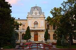 .The Olt County Prefecture's building from the interwar period, currently the Olt County Museum. | ||
| ||
 | ||
| Country |
| |
| Historic region | Muntenia | |
| Capital city (Reședință de județ) | Slatina | |
| Area | ||
| • Total | 2,863 km2 (1,105 sq mi) | |
| Population (1930) | ||
| • Total | 183,595 | |
| • Density | 64/km2 (170/sq mi) | |
| Time zone | UTC+2 (EET) | |
| • Summer (DST) | UTC+3 (EEST) | |
Historically, the county was located in the southern part of Greater Romania, in the western part of the historical region of Muntenia, around and in the south of Bucharest. The county included the north-eastern part of the current Olt county, the south-western part of the present Argeș County and the north-western part of the present Teleorman County. During the interwar years, it was bordered to the north by Argeș County, to the east by the counties of Argeş and Teleorman, to the south by Teleorman County, and in the west by the counties of Romanați and Vâlcea.
Administration
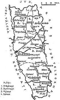
The county originally was divided into three administrative districts (plăṣi):[8]
- Plasa Drăgănești, headquartered at Drăgănești
- Plasa Dumitrești, headquartered at Dumitrești
- Plasa Spineni, headquartered at Spineni
Subsequently, the county established an additional district:
- Plasa Mijlocul, head quartered at Mijlocul
Population
According to the 1930 census data, the county population was 183,595 inhabitants, ethnically divided as follows: 98.2% Romanians, 1.2% Romanies, as well as other minorities. From the religious point of view, the population was 99.5% Eastern Orthodox, 0.2% Roman Catholic, 0.1% Jewish, as well as other minorities.
Urban population
In 1930, the county's urban population was 11,243 inhabitants, comprising 792.5% Romanians, 2.5% Hungarians, 1.5% Jews, 0.8% Germans, as well as other minorities. From the religious point of view, the urban population was composed of 94.1% Eastern Orthodox, 2.3% Roman Catholic, 1.6% Jewish, 0.9% Reformed, 0.6% Lutheran, as well as other minorities.
References
| Wikimedia Commons has media related to Olt County. |
- ↑ "COMUNICAT DE PRESĂ : 2 februarie 2012 privind rezultatele provizorii ale Recensământului Populaţiei şi Locuinţelor – 2011" (PDF). Prefecturaolt.ro. Retrieved 11 April 2018.
- ↑ The number used depends on the numbering system employed by the phone companies on the market.
- ↑ "Olt: CJ a programat pe 15 octombrie referendumul pentru schimbarea numelui județului" (in Romanian). Agerpres. 24 August 2017. Retrieved 3 September 2017.
- ↑ "CJ Olt a decis: Face referendum de schimbare a numelui, simultan cu cel pentru familie" (in Romanian). Ziare.com. 17 September 2018. Retrieved 17 September 2018.
- ↑ National Institute of Statistics, "Populația după etnie" Archived 2009-08-16 at the Wayback Machine.
- ↑ National Institute of Statistics, "Populația la recensămintele din anii 1948, 1956, 1966, 1977, 1992 și 2002"
- ↑ "Mandate de CJ pe judete si competitori" (in Romanian). Biroul Electoral Central. 10 June 2016. Retrieved 16 June 2016.
- ↑ Portretul României Interbelice - Județul Olt