Arad County
| Arad County Județul Arad | ||
|---|---|---|
| County | ||
| ||
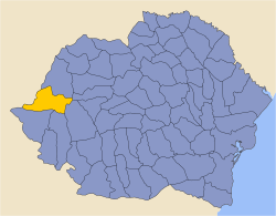
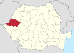 Location of Arad County in Romania | ||
| Coordinates: 46°22′N 21°48′E / 46.36°N 21.8°ECoordinates: 46°22′N 21°48′E / 46.36°N 21.8°E | ||
| Country |
| |
| Development region1 | Vest | |
| Historic region | Crișana | |
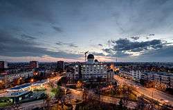
| Capital city (Reședința de județ) | Arad | |
| Județul Arad | 1968 | |
| Government | ||
| • Type | County Council | |
| • President of the County Board | Iustin Cionca (National Liberal Party) | |
| • Prefect2 | Călin Bibarț | |
| Area | ||
| • Total | 7,754 km2 (2,994 sq mi) | |
| Area rank | 5th in Romania | |
| Elevation | 1,486 m (4,875 ft) | |
| Population (2011) | ||
| • Total | 409,072 | |
| • Rank | 21st in Romania | |
| • Density | 53/km2 (140/sq mi) | |
| Time zone | UTC+2 (EET) | |
| • Summer (DST) | UTC+3 (EEST) | |
| Postal Code | 31wxyz3 | |
| Area code(s) | +40 x574 | |
| Car Plates | AR5 | |
| GDP | US$ 5.24 billion (2008) | |
| GDP/capita | US$ 11,337 (2008) | |
| Website |
County Council County Prefecture | |
|
1 The development regions of Romania have no administrative role and were formed in order to manage funds from the European Union. 2 as of 2007, the Prefect is not a politician, but a public functionary. He (or she) is not allowed to be a member of a political party, and is banned from having any political activity in the first six months after his resignation (or exclusion) from the public functionaries' corps. 3w, x, y, and z are digits that indicate the city, the street, part of the street, or eaven the building of the address 4x is a digit indicating the operator: 2 for the former national operator, Romtelecom, and 3 for the other ground telephone networks 5used on both the plates of the vehicles that operate only in the county limits (like utilitary vehicles and ATVs, etc.), and the ones used outside the county | ||
Arad County (Romanian pronunciation: [aˈrad] (![]()
Name
In Hungarian, it is known as Arad megye, in Serbian as Арад / Arad, and in German as Kreis Arad. The county was named after its administrative center, Arad.
Geography
The county has a total area of 7,754 km², representing 3.6% of national Romanian territory. The terrain of Arad County is divided into two distinct units that cover almost half of the county each. The eastern side of the county has a hilly to low mountainous terrain (Dealurile Lipovei, Munții Zărandului, Munții Codru Moma) and on the western side it's a plain zone consisting of the Arad Plain, Low Mures Plain, and The High Vinga Plain. Taking altitude into account we notice that it follows a stepped pattern as it drops as we go from the east to the west of the county from 1489 m to below 100 m. In the east there are the Zarand Mountainsnand the Codru Moma Mountains, all subdivisions of the Apuseni Mountains, a major group of the Western Carpathians.
Neighbours
- Alba County and Hunedoara County to the East.
- Hungary to the West - Békés and Csongrád Counties.
- Bihor County to the North.
- Timiș County to the South.
Climate and precipitation
In terms of climate, the characteristics of Arad county have a typical temperate continental climate with oceanic influences, with a circulation of air masses with a predominantly western ordered direction visible from west to east, with increasing altitude. Average annual temperatures range from 10 °C in the lowlands, the hills and piedmonts 9 °C, 8 °C and 6 °C in the low mountains in the area of greatest height. Average amounts of precipitation fall in values between 565–600 mm annually in the lowlands, 700–800 mm annually in the hills and piedmonts and 800–1200 mm annually in the mountainous area.
Hydrographic network
The hydrographic network is composed of the two main rivers plus their tributaries and channels.
- Mureṣ - Corbeasca, Troaş, Bârzava, Milova, Cladova
- Criṣul Alb - Hălmăgel, Valea Leucii, Tăcaşele, Cremenoasa, Zimbru, Valea Deznei, Valea Monesei, Tălagiu, Honțisor, Chişindia, Cigher
Lakes, ponds and channels
- Tauț, Seleuș, Cermei, Rovine, Matca (Ghioroc) Lakes and Gypsy Pond
- Matca, Canalul Morilor, Canalul Morilor, Ier, Criș Channels
Demographics
In October 31, 2011, it had a population of 409,072 and the population density was 52/km².[1] The main ethnic composition was, as follows:
- Romanians - 83.88%
- Hungarians - 9.06%
- Roma - 4.04%
| Year | County population[2] |
|---|---|
| 1948 | 476,207 |
| 1956 | 475,620 |
| 1966 | 481,248 |
| 1977 | 512,020 |
| 1992 | 487,370 |
| 2002 | 461,791 |
| 2011 | 409,072 |
Economy
Along with Timiș County it forms one of the most developed regions in Romania. Due to its proximity to the border, it attracts a great number of foreign investments. The agricultural potential is greatly put into value, Arad plains being considered one of the most important cereal and vegetable producing basins.
The predominant industries in the county are:
- Machine and automotive components.
- Food.
- Textiles.
Natural resources in Arad, are worthy to be taken into account as there are oil and associated gases, points of extraction in the west of the county, molibden mines in the Săvârșin area, marble quarries at Căprioara and Moneasa, mineral waters at Lipova, Moneasa, Dorobanți, Curtici, Macea and uranium deposits in the NE part of the county.
Tourism
The main tourist destinations are:
Politics
The Arad County Council, elected at the 2016 local government elections, is made up of 33 counselors, with the following party composition:[3]
| Party | Seats | Current County Council | ||||||||||||||||
|---|---|---|---|---|---|---|---|---|---|---|---|---|---|---|---|---|---|---|
| National Liberal Party | 16 | |||||||||||||||||
| Social Democratic Party | 11 | |||||||||||||||||
| Alliance of Liberals and Democrats | 2 | |||||||||||||||||
| People's Movement Party | 2 | |||||||||||||||||
| Democratic Alliance of Hungarians in Romania | 2 | |||||||||||||||||
Administrative divisions
Arad County has 1 municipality, 9 towns and 68 communes with approximately 180 villages.
- Municipalities
- Arad - capital city; population: 172,827 (as of 2002)
- Towns
- Communes
- Almaș
- Apateu
- Archiș
- Bata
- Bârsa
- Bârzava
- Beliu
- Birchiș
- Bocsig
- Brazii
- Buteni
- Cărand
- Cermei
- Chisindia
- Conop
- Covăsânț
- Craiva
- Dezna
- Dieci
- Dorobanți
- Fântânele
- Felnac
- Frumușeni
- Ghioroc
- Grăniceri
- Gurahonț
- Hălmagiu
- Hălmăgel
- Hășmaș
- Ignești
- Iratoșu
- Livada
- Macea
- Mișca
- Moneasa
- Olari
- Păuliș
- Peregu Mare
- Petriș
- Pilu
- Pleșcuța
- Săvârșin
- Secusigiu
- Seleuș
- Semlac
- Sintea Mare
- Socodor
- Șagu
- Șeitin
- Șepreuș
- Șicula
- Șilindia
- Șimand
- Șiria
- Șiștarovăț
- Șofronea
- Tauț
- Târnova
- Ususău
- Vărădia de Mureș
- Vârfurile
- Vinga
- Vladimirescu
- Zăbrani
- Zădăreni
- Zărand
- Zerind
- Zimandu Nou
Historical county
| Județul Arad | ||
|---|---|---|
| County (Județ) | ||
| ||
 | ||
| Country |
| |
| Historic region | Crișana | |
| Capital city (Reședință de județ) | Arad | |
| Ceased to exist | 1950 | |
| Area | ||
| • Total | 6,248 km2 (2,412 sq mi) | |
| Population (1930) | ||
| • Total | 423,469 | |
| • Density | 68/km2 (180/sq mi) | |
| Time zone | UTC+2 (EET) | |
| • Summer (DST) | UTC+3 (EEST) | |
Administration
In 1930, the county was divided into nine districts (plăṣi):[4]
- Plasa Aradul-Nou (comprising 22 villages)
- Plasa Chișineu-Criș (comprising 19 villages)
- Plasa Hălmagiu (comprising 45 villages)
- Plasa Ineu (comprising 15 villages)
- Plasa Pecica (comprising 12 villages)
- Plasa Sfânta Ana (comprising 13 villages)
- Plasa Sebiș (comprising 37 villages)
- Plasa Șiria (comprising 11 villages)
- Plasa Radna (comprising 36 villages)
Subsequently, a tenth district was established having been carved out of Plasa Ineu:
- Plasa Târnova (comprising 16 villages)
Administration was re-organized in 1947, comprising 13 districts:[5]
- Plasa Aradul-Nou
- Plasa Chișineu-Criș
- Plasa Curtici
- Plasa Gurahonț
- Plasa Hălmagiu
- Plasa Ineu
- Plasa Pecica
- Plasa Radna
- Plasa Săvârșin
- Plasa Sebiș
- Plasa Sfânta Ana
- Plasa Șiria
- Plasa Târnova
Population
According to the 1930 census data, the county population was 423,469 inhabitants, 61.0% Romanians, 19.5% Hungarians, 12.3% Germans, 2.8% Slovaks, 2.1% Jews, as well as other minorities. From the religious point of view, 55.8% declared Eastern Orthodox, 26.5% Roman Catholic, 5.5% Reformed, 4.2% Greek Catholic, 3.2% Lutherans, 2.4% Jewish, 1% Baptists, as well as other minorities.[6]
Urban population
In 1930, the county's urban population was 77,181 inhabitants, 39.3% Romanians, 38.8% Hungarians, 9.1% Jews, 7.1% Germans, 1.7% Serbs and Croats, 1.4% Slovaks, as well as other minorities. In the urban area, languages were Hungarian (53.3%), Romanian (37.0%), German (6.0%), Serbian (1.4%), Yiddish (0.9%), as well as other minorities. From the religious point of view, the urban population was composed of Roman Catholics (38.5%), Eastern Orthodox (33.8%), Jewish (10.1%), Reformed (9.9%), Greek Catholics (4.0%), Lutherans (2.6%), as well as other minorities.[6]
References
| Wikimedia Commons has media related to Arad County. |
- ↑ "COMUNICAT DE PRESĂ : 2 februarie 2012 privind rezultatele provizorii ale Recensământului Populaţiei şi Locuinţelor – 2011" (PDF). Recensamantromania.ro. Retrieved 11 April 2018.
- ↑ National Institute of Statistics, "Populaţia la recensămintele din anii 1948, 1956, 1966, 1977, 1992, 2002 şi 2011"
- ↑ "Mandate de CJ pe judete si competitori" (in Romanian). Biroul Electoral Central. 10 June 2016. Retrieved 16 June 2016.
- ↑ Portretul României Interbelice - Județul Arad
- ↑ Arhivele Naționale ale României - Prefectura județului Arad 1867-1947
- 1 2 Recensământul general al populației României din 29 decemvrie 1930, Vol. II, pag. 525-528
External links
| Authority control |
|---|