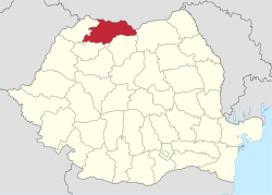
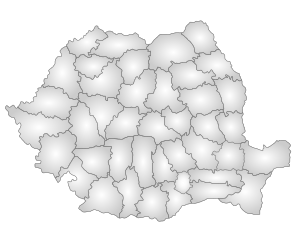
Maramureș County
| Maramureș County Județul Maramureș | ||
|---|---|---|
| County | ||
| ||
 | ||
| Country | Romania | |
| Development region | Nord-Vest | |
| Historical region | Maramureș | |
| Capital | Baia Mare | |
| Area | ||
| • Total | 6,304 km2 (2,434 sq mi) | |
| Area rank | 15th | |
| Population (2006)[1] | ||
| • Total | 516,562 | |
| • Rank | 17th | |
| • Density | 82/km2 (210/sq mi) | |
| Telephone code | (+40) 262 or (+40) 362[2] | |
| ISO 3166 code | RO-MM | |
| Website |
County Council Prefecture | |
Maramureș County (Romanian pronunciation: [maraˈmureʃ] (![]()
Name
In Hungarian, it is known as Máramaros megye, in Ukrainian as Мараморо́щина, and in German as Kreis Marmarosch.
Demographics
In 2011, the county had a population of 461,290 and a population density of 73.17 inhabitants per square kilometre (189.5/sq mi).
- Romanians - 82.38% (or 380,018)[3]
- Hungarians - 7.53% (or 34,781)
- Ukrainians (including Hutsuls and other Rusyns) - 6.77% (or 31,234)
- Romani - 2.73% (or 12,638)
- Germans (Zipser Germans) - 0.27% (or 1,243), and others.
In 1910, 18.4% of the county were Jewish.
| Year | County population[4] |
|---|---|
| 1948 | 321,287 |
| 1956 | |
| 1966 | |
| 1977 | |
| 1992 | |
| 2002 | |
| 2011 |
Geography
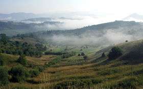
Maramureș County is situated in the northern part of Romania, and has a border with Ukraine. This county has a total area of 6,304 square kilometres (2,434 sq mi), of which 43% is covered by the Rodna Mountains, with its tallest peak, Pietrosul, at 2,303 metres (7,556 ft) altitude. Together with Gutâi and Țibleș mountain ranges, the Rodna mountains are part of the Eastern Carpathians. The rest of the county are hills, plateaus, and valleys. The county is crossed by Tisa River and its main tributaries: Iza, Vișeu, and Mara rivers.
Neighbours
- Suceava County to the East.
- Satu Mare County to the West.
- Ukraine to the North - Ivano-Frankivsk Oblast and Zakarpattia Oblast.
- Sălaj County, Cluj County and Bistrița-Năsăud County to the South.
Economy
Maramureș is known for its pastoral and agricultural traditions, largely unscathed by the industrialisation campaign that had been carried on during Romania's communist period. Ploughing, planting, harvesting, and hay making and handling are mostly done through manual labour. The county is also home to a strong mining industry of extraction of metals other than iron. The industrial plants built around Baia Mare during the communist period heavily polluted the area in the past, but recently, due to the decline of the city's industrial activity, the area is less polluted.
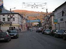
Tourism

The region is known for its beautiful rural scenery, local small woodwork and craftwork industry as well as for its churches and original rural architecture. There are not many paved roads in rural areas, and most of them are usually accessible.
The county's main tourist attractions:
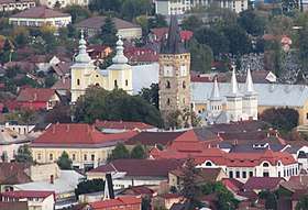
- The cities of Baia Mare and Sighetu Marmației.
- The villages on the Iza, Mara, and Vișeu Valleys.
- The Wooden churches of Maramureș
- The Wooden churches of Lăpuș
- The Wooden churches of Chioar
- The Merry Cemetery of Săpânța
- The Rodna Mountains.
- The landscape of Cavnic.
Politics
The Maramureș County Council, elected at the 2016 local government elections, is made up of 35 counselors, with the following party composition:[5]
| Party | Seats | Current County Council | ||||||||||||||
|---|---|---|---|---|---|---|---|---|---|---|---|---|---|---|---|---|
| Social Democratic Party | 14 | |||||||||||||||
| National Liberal Party | 9 | |||||||||||||||
| Coalition for Baia Mare (FDGR, PNȚCD, UNPR, PSRO) |
5 | |||||||||||||||
| People's Movement Party | 3 | |||||||||||||||
| Ecologist Party | 2 | |||||||||||||||
| Democratic Alliance of Hungarians | 2 | |||||||||||||||
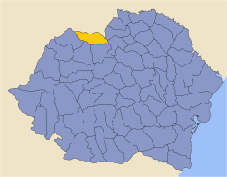
Administrative divisions
.JPG)

Maramureș County has 2 municipalities, 11 towns and 63 communes.
- Municipalities
- Baia Mare - county seat; population: 114,925 (as of 2011)
- Sighetu Marmației
- Communes
- Ardusat
- Ariniș
- Asuaju de Sus
- Băița de sub Codru
- Băiuț
- Bârsana
- Băsești
- Bicaz
- Bistra
- Bocicoiu Mare
- Bogdan Vodă
- Boiu Mare
- Botiza
- Breb
- Budești
- Călinești
- Câmpulung la Tisa
- Cernești
- Cicârlău
- Coaș
- Coltău
- Copalnic-Mănăștur
- Coroieni
- Cupșeni
- Desești
- Dumbrăvița
- Fărcașa
- Gârdani
- Giulești
- Groși
- Groșii Țibleșului
- Ieud
- Lăpuș
- Leordina
- Mireșu Mare
- Moisei
- Oarța de Jos
- Ocna Șugatag
- Onceşti
- Petrova
- Poienile de sub Munte
- Poienile Izei
- Recea
- Remetea Chioarului
- Remeți
- Repedea
- Rona de Jos
- Rona de Sus
- Rozavlea
- Ruscova
- Săcălășeni
- Săcel
- Sălsig
- Săpânța
- Sarasău
- Satulung
- Șieu
- Șișești
- Strâmtura
- Suciu de Sus
- Vadu Izei
- Valea Chioarului
- Vima Mică
- Vișeu de Jos
Historical county
| Județul Maramureș | ||
|---|---|---|
| County (Județ) | ||
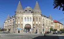
.JPG) The Maramureş County Prefect's building from the interwar period. | ||
| ||
 | ||
| Country |
| |
| Historic region | Maramureș | |
| Capital city (Reședință de județ) | Sighet | |
| Area | ||
| • Total | 3,381 km2 (1,305 sq mi) | |
| Population (1930) | ||
| • Total | 194,619 | |
| • Density | 58/km2 (150/sq mi) | |
| Time zone | UTC+2 (EET) | |
| • Summer (DST) | UTC+3 (EEST) | |
History
- The 10th century frontier county of Borsova was founded by Stephen I of Hungary.
- In the 12th century by the separation from Borsova (Borșa) Máramaros County in created in the north-eastern border of the Kingdom of Hungary.
- In 1241 the Tatar invasion decimated about half of the local population.
- Inthe 14th century Duke (knyaz) Bogdan of Maramureș said to be founder of Moldavia.
- In the Middle Ages, the historical region of Máramaros (Maramureș) was known for its salt mines and later for its lumber.
In 1920 after the Treaty of Trianon, the northern part of the county became part of newly formed Czechoslovakia. The southern part (including Sighetu Marmației) became part of the Kingdom of Romania.
After the administrative unification law in 1925, the county remained as it was, with the identical name and territory.
In 1938, King Carol II promulgated a new Constitution, and subsequently he had the administrative division of the Romanian territory changed. 10 ținuturi (approximate translation: "lands") were created (by merging the counties) to be ruled by rezidenți regali (approximate translation: "Royal Residents") - appointed directly by the King - instead of the prefects. Maramureș County became part of Ținutul Crișuri.
In 1940, the county was transferred back to Hungary with the rest of Northern Transylvania under the Second Vienna Award. Beginning in 1944, Romanian forces with Soviet assistance recaptured the ceded territory and reintegrated it into Romania, re-establishing the county. Romanian jurisdiction over the county per the Treaty of Trianon was reaffirmed in the Paris Peace Treaties, 1947. The county was disestablished by the communist government of Romania in 1950, and re-established in 1968 when Romania restored the county administrative system.
Administration

In 1930, the county was originally divided into three districts (plăṣi):[6]
- Plasa Iza
- Plasa Sighet (headquartered at Sighet)
- Plasa Vișeu (headquarted at Vișeu de Sus)
Subsequently the Iza and Sighet districts were reorganized into three districts, adding one:
- Plasa Şugatag (headquarted at Ocna Şugatag)
Population
According to the 1930 census, the county's population was 194,619, 57.9% Romanian, 20.9% Jews, 11.9% Ruthenians (including Ukrainians), 6.9% Hungarians, 2.0% Germans, as well as other minorities.[7] The following composition was recorded from the religious point of view: 64.4% Greek Catholic, 21.0% Jewish, 6.4% Roman Catholic, 5.3% Eastern Orthodox, 1.8% Reformed, as well as other minorities.[7]
Urban population
In 1930, the county's urban population ethnically consisted of 38.6% Jews, 35.4% Romanians, 19.9% Hungarians, 4.5% Ruthenians (including Ukrainians), as well as other minorities. Yiddish was spoken by 36.6% of the urban population, followed by Romanian (33.7%), Hungarian (25.7%), Ukrainian (2.3%), as well as other minorities. From the religious point of view, the urban inhabitants were Jewish (38.9%), Greek Catholics (38.0%), Roman Catholics (12.8%), Reformed (5.7%), Eastern Orthodox (3.5%), as well as other minorities.[7]
People
Natives of the county include:
References
| Wikivoyage has a travel guide for Maramureș. |
| Wikimedia Commons has media related to Maramureș County. |
- ↑ INSSE Statistic Archived 2010-08-07 at the Wayback Machine.
- ↑ The number used depends on the numbering system employed by the phone companies on the market.
- ↑ National Institute of Statistics, "Populația după etnie" Archived 2009-08-16 at the Wayback Machine.
- ↑ National Institute of Statistics, "Populația la recensămintele din anii 1948, 1956, 1966, 1977, 1992 și 2002" Archived 2006-09-22 at the Wayback Machine.
- ↑ "Mandate de CJ pe judete si competitori" (in Romanian). Biroul Electoral Central. 10 June 2016. Retrieved 16 June 2016.
- ↑ Portretul României Interbelice - Județul Maramureș
- 1 2 3 Recensământul general al populației României din 29 decemvrie 1930, Vol. II, pag. 276-277
Coordinates: 47°40′22″N 24°00′18″E / 47.67278°N 24.00500°E