Teleorman County
| Teleorman County Județul Teleorman | ||
|---|---|---|
| County | ||
| ||
 | ||
| Country | Romania | |
| Historical region | Muntenia | |
| Capital | Alexandria | |
| Area | ||
| • Total | 5,790 km2 (2,240 sq mi) | |
| Area rank | 19th | |
| Population (2011) | ||
| • Total | 360,178 | |
| • Rank | 24th | |
| • Density | 62/km2 (160/sq mi) | |
| Telephone code | (+40) 247 or (+40) 347[1] | |
| ISO 3166 code | RO-TR (TR county) | |
| Website | Prefecture | |

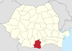
Teleorman County (Romanian pronunciation: [ˈtele.orman]) is a county (județ) of Romania on the border with Bulgaria, in the historical region Muntenia, with its capital city at Alexandria.
The name Teleorman is of Cumanic (Turkic) origin. It literally means crazy forest (Deli orman) and, by extension, "thick and shadowy forest" in the Cuman language.[2] It can be encountered in other toponyms, such as the Turkish name of the Ludogorie Plateau in northeastern Bulgaria.
Demographics
In 2011, it had a population of 360,178 and the population density was 62.2/km².
| Year | County population[4] |
|---|---|
| 1948 | 487,394 |
| 1956 | |
| 1966 | |
| 1977 | |
| 1992 | |
| 2002 | |
| 2011 |
Geography
This county has a total area of 5,790 km².
Two distinctive elements can be found:
- In the North and center there are plains from the Romanian Plain. They are separated by small rivers, which sometimes form deep valleys.
- In the South there is the Danube valley, very wide, with ponds and small channels.
Beside the Danube, the main river crossing the county is the Olt River which flows into the Danube close to the village of Islaz. Other important rivers are: the Vedea River, the Teleorman River and the Călmățui River.
Neighbours
- Giurgiu County in the East.
- Olt County in the West.
- Argeș County and Dâmbovița County in the North.
- Bulgaria in the South - Veliko Tarnovo Province, Pleven Province and Ruse Province.
Economy
The predominant industries in the county are:
- Food and beverages industry.
- Textile industry.
- Chemical industry.
- Mechanical components industry - in Alexandria there is a big roll-bearing enterprise.
Agriculture is the main occupation in the county. Both extensive agriculture, and small scale - vegetables and fruits for Bucharest markets, is practiced. The area is well suited for irrigations.
Tourism

The county doesn't have many spectacular attractions, but its cultural folk heritage is very rich. Many Romanian personalities have been born here, some of them later describing the life in a village in a very picturesque way. Also, the area was one of the places where the Wallachian Revolution of 1848 unfolded.
The main tourist destinations are:
- The city of Alexandria.
- Fishing on the Danube and other lakes or ponds.
Politics
The Teleorman County Council, elected at the 2016 local government elections, is made up of 33 counselors, with the following party composition:[5]
| Party | Seats | Current County Council | ||||||||||||||||||
|---|---|---|---|---|---|---|---|---|---|---|---|---|---|---|---|---|---|---|---|---|
| Social Democratic Party | 18 | |||||||||||||||||||
| National Liberal Party | 11 | |||||||||||||||||||
| Alliance of Liberals and Democrats | 2 | |||||||||||||||||||
| People's Movement Party | 2 | |||||||||||||||||||
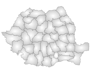
Administrative divisions


Teleorman County has 3 municipalities, 2 towns and 93 communes
- Municipalities
- Alexandria - capital city; population: 42,129 (as of 2011)
- Roșiorii de Vede
- Turnu Măgurele
- Towns
- Communes
- Băbăița
- Balaci
- Beciu
- Beuca
- Blejești
- Bogdana
- Botoroaga
- Bragadiru
- Brânceni
- Bujoreni
- Bujoru
- Buzescu
- Călinești
- Călmățuiu
- Călmățuiu de Sus
- Cervenia
- Ciolănești
- Ciuperceni
- Conțești
- Cosmești
- Crângu
- Crevenicu
- Crângeni
- Didești
- Dobrotești
- Dracea
- Drăcșenei
- Drăgănești de Vede
- Drăgănești-Vlașca
- Fântânele
- Frăsinet
- Frumoasa
- Furculești
- Gălăteni
- Gratia
- Islaz
- Izvoarele
- Lisa
- Lița
- Lunca
- Măgura
- Măldăeni
- Mârzănești
- Mavrodin
- Mereni
- Moșteni
- Nanov
- Năsturelu
- Necșești
- Nenciulești
- Olteni
- Orbeasca
- Peretu
- Piatra
- Pietroșani
- Plopii-Slăvitești
- Plosca
- Poeni
- Poroschia
- Purani
- Putineiu
- Rădoiești
- Răsmirești
- Săceni
- Saelele
- Salcia
- Sârbeni
- Scrioaștea
- Scurtu Mare
- Seaca
- Segarcea-Vale
- Sfințești
- Siliștea
- Siliștea Gumești
- Slobozia Mândra
- Smârdioasa
- Stejaru
- Ștorobăneasa
- Suhaia
- Talpa
- Tătărăștii de Jos
- Tătărăștii de Sus
- Țigănești
- Traian
- Trivalea-Moșteni
- Troianul
- Uda-Clocociov
- Vârtoape
- Vedea
- Viișoara
- Vitănești
- Zâmbreasca
People
Teleorman County is home to many Romanian personalities including:
Historical county
| Județul Teleorman | ||
|---|---|---|
| County (Județ) | ||
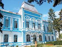
 The Teleorman County court building of the interwar period, currently the Turnu Măgurele city court building. | ||
| ||
 | ||
| Country |
| |
| Historic region | Muntenia | |
| Capital city (Reședință de județ) | Turnu Măgurele | |
| Area | ||
| • Total | 4,577 km2 (1,767 sq mi) | |
| Population (1930) | ||
| • Total | 347,294 | |
| • Density | 76/km2 (200/sq mi) | |
| Time zone | UTC+2 (EET) | |
| • Summer (DST) | UTC+3 (EEST) | |
Historically, the county was located in the southern part of Greater Romania, in the southwestern part of the historical region of Muntenia. Its capital was Turnu Măgurele. The county was bordered on the west by the counties Romanați County and Olt County, to the north by Argeş County, to the east by Vlașca County, and in the south across the Danube River by the Kingdom of Bulgaria. Its territory coincides in large part with that of the present county.
Administration
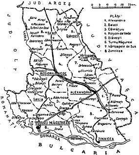
The county was originally divided into five administrative districts (plăṣi):[6]
- Plasa Alexandria, headquartered at Alexandria
- Plasa Balaci, headquartered at Balaci
- Plasa Roșiori de Vede, headquartered at Roșiori de Vede
- Plasa Turnu Măgurele, headquartered at Turnu Măgurele
- Plasa Zimnicea, headquartered at Zimnicea
Subsequently, the county established three more districts:
- Plasa Călmățuiu, headquartered at Călmățuiu
- Plasa Slăvești, headquartered at Slăvești
- Plasa Vârtoapele de Sus, headquartered at Vârtoapele de Sus
The county contained four urban communes: Turnu Măgurele, Alexandria, Roșiorii de Vede, and Zimnicea.
Population
According to the 1930 census data, the county population was 347,294 inhabitants, ethnically divided as follows: 98.1% Romanians, 1.4% Romanies, as well as other minorities. From the religious point of view, the population was 99.0% Eastern Orthodox, 0.6% Adventist, 0.1% Muslim, as well as other minorities.
Urban population
In 1930, the county's urban population was 58,632 inhabitants, comprising 94.4% Romanians, 3.3% Romanies, 0.4% Hungarians, 0.4% Jews, as well as other minorities. From the religious point of view, the urban population was composed of 98.1% Eastern Orthodox, 0.6% Muslim, 0.4% Jewish, 0.4% Roman Catholic, as well as other minorities.
References
| Wikimedia Commons has media related to Teleorman County. |
- ↑ The number used depends on the numbering system employed by the phone companies on the market.
- ↑ (in Romanian) Claudiu Dumitrache, "Județul Teleorman, de la 'pădurea nebună' la grânarul țării", Adevărul, January 11, 2013; accessed July 2, 2013
- ↑ National Institute of Statistics, "Populația după etnie" Archived 2009-08-16 at the Wayback Machine.
- ↑ National Institute of Statistics, "Populația la recensămintele din anii 1948, 1956, 1966, 1977, 1992 și 2002"
- ↑ "Mandate de CJ pe judete si competitori" (in Romanian). Biroul Electoral Central. 10 June 2016. Retrieved 16 June 2016.
- ↑ Portretul României Interbelice - Județul Teleorman
External links
Coordinates: 43°39′25″N 25°21′25″E / 43.65694°N 25.35694°E