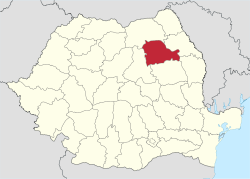
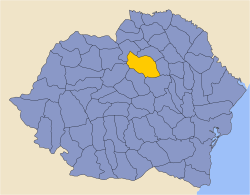
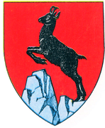
Neamț County
| Neamț County Județul Neamț | ||
|---|---|---|
| County | ||
| ||
 | ||
| Coordinates: 46°58′N 26°24′E / 46.97°N 26.4°ECoordinates: 46°58′N 26°24′E / 46.97°N 26.4°E | ||
| Country | Romania | |
| Development region | Nord-Est | |
| Historical region | Moldavia | |
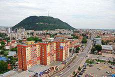
| Capital | Piatra Neamț | |
| Area | ||
| • Total | 5,897 km2 (2,277 sq mi) | |
| Area rank | 18th | |
| Population (2011) | ||
| • Total | 470,766 | |
| • Rank | 17th | |
| • Density | 80/km2 (210/sq mi) | |
| Telephone code | (+40) 233 or (+40) 333[1] | |
| ISO 3166 code | RO-NT | |
| Website |
County Council Prefecture | |

Neamț County (Romanian pronunciation: [ne̯amt͡s] (![]()
Demographics
In 2011, it had a population of 470,766 and a population density of 80/km².
- Romanians - 98.25%[2]
- Lipovans - 0.05%
- Hungarians - 0.04%
- Roma - 1.48%, and others
| Year | County population[3] |
|---|---|
| 1948 | 357,348 |
| 1956 | |
| 1966 | |
| 1977 | |
| 1992 | |
| 2002 | |
| 2011 |
Geography
This county has an area of 5,897 km².[4]:17
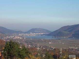
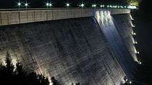
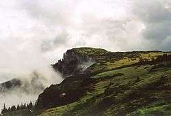
The relief decreases from west to east. In the western part, there are mountains, the Eastern Carpathians, with heights of over 1800m and the impressive peak of Mount Ceahlău. Along the Bicaz River lies the canyon of Cheile Bicazului. Construction of the Bicaz Dam in the 1950s on the Bistrița River led to the formation of the Lake Bicaz (Lake Izvorul Muntelui), the largest artificial lake completely in Romania.[4]:15
On the western side, the lowest point, at about 160m, is found along Siret River's valley.
Neighbours
- Iași County and Vaslui County in the East.
- Harghita County in the West.
- Suceava County in the North.
- Bacău County in the South.
Economy
County's main industries:
- Chemical industry;
- Mechanical parts;
- Textiles;
- Food stuffs;
- Construction materials.
One of the greatest dams in Romania, the Bicaz Dam is built along the Bistrița River, forming the Bicaz Lake; the water of the lake is used for electricity production at Bicaz-Stejaru Hydroelectric Power Station.
Tourism
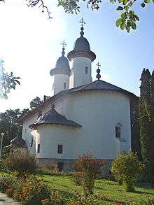
Neamț county is known as the region with the most monasteries to be found per square kilometer in the world. The monumental church of Neamț Monastery has been a model for Moldavian churches and monasteries. The Moldavian art style, of great originality and stylistic unity, was developed by blending Gothic elements with Byzantine motifs.
The county is host to two of Romania's 9 national parks: Ceahlău Massif and Vânători-Neamț Natural Park
County's main tourist attractions include
- The city of Piatra Neamț, with its medieval square and ski facilities;
- The city of Roman
- Agapia Monastery
- Bistrița Monastery
- Durău Monastery
- Horaița Monastery
- Neamț Monastery
- Pângărați Monastery
- Petru Vodă Monastery
- Războieni Monastery
- Secu Monastery
- Sihăstria Monastery
- Sihla Monastery
- Văratec Monastery
- Vânători-Neamț Natural Park
- Neamț Citadel in Târgu Neamț
- Ceahlău National Park
- Bicaz Canyon - "Cheile Bicazului"
- Durău Ski Resort
- Hanu Ancuței
Politics
The Neamț County Council, elected at the 2016 local government elections, is made up of 35 counselors, with the following party composition:[5]
| Party | Seats | Current County Council | |||||||||||||||||
|---|---|---|---|---|---|---|---|---|---|---|---|---|---|---|---|---|---|---|---|
| PSD-UNPR Electoral Alliance | 17 | ||||||||||||||||||
| National Liberal Party | 14 | ||||||||||||||||||
| Alliance of Liberals and Democrats | 2 | ||||||||||||||||||
| People's Movement Party | 2 | ||||||||||||||||||
Administrative divisions
Neamț County has 2 municipalities, 3 towns and 78 communes
- Municipalities
- Piatra Neamț - capital city; population: 77,393 (as of 2011 census)
- Roman - population: 45,344 (as of 2011 census)
- Towns
- Communes
- Agapia
- Alexandru cel Bun
- Bahna
- Bălțătești
- Bârgăuani
- Bicaz-Chei
- Bicazu Ardelean
- Bâra
- Bodești
- Boghicea
- Borca
- Borlești
- Botești
- Bozieni
- Brusturi
- Cândești
- Ceahlău
- Cordun
- Costișa
- Crăcăoani
- Dămuc
- Dobreni
- Dochia
- Doljești
- Dragomirești
- Drăgănești
- Dulcești
- Dumbrava Roșie
- Farcașa
- Făurei
- Gâdinți
- Gârcina
- Gherăești
- Ghindăoani
- Girov
- Grințieș
- Grumăzești
- Hangu
- Horia
- Icușești
- Ion Creangă
- Mărgineni
- Moldoveni
- Negrești
- Oniceni
- Păstrăveni
- Pâncești
- Pângărați
- Petricani
- Piatra Șoimului
- Pipirig
- Podoleni
- Poiana Teiului
- Poienari
- Răucești
- Războieni
- Rediu
- Români
- Ruginoasa
- Sagna
- Săbăoani
- Săvinești
- Secuieni
- Stănița
- Ștefan cel Mare
- Tarcău
- Tașca
- Tazlău
- Tămășeni
- Timișești
- Trifești
- Tupilați
- Țibucani
- Urecheni
- Valea Ursului
- Văleni
- Vânători-Neamț
- Zănești
Natives
- Sergiu Celibidache, conductor
- Vasile Conta, philosopher
- Ion Creangă, writer
- Virgil Gheorghiu, writer
- Ștefan Macovei, contemporary sculptor
- Nicodim Munteanu, patriarch
Historical county
| Județul Neamț | ||
|---|---|---|
| County (Județ) | ||
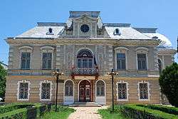
 The Neamț County Prefect's building from the interwar period, currently the county museum. | ||
| ||
 | ||
| Country |
| |
| Historic region | Moldavia | |
| Capital city (Reședință de județ) | Piatra Neamț | |
| Area | ||
| • Total | 3,977 km2 (1,536 sq mi) | |
| Population (1930) | ||
| • Total | 198,223 | |
| • Density | 50/km2 (130/sq mi) | |
| Time zone | UTC+2 (EET) | |
| • Summer (DST) | UTC+3 (EEST) | |
The county was located in the north-eastern part of Romania, in the north-west of the region of Moldavia. Today, most of the territory of the former county is part of the current Neamț County. It was bordered on the north by Câmpulung County, to the north-east by Baia County, to the east by Roman County, to the south by Bacău County, to the southwest by Ciuc County, and to the west by Mureş County.
Administration
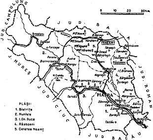
In 1930, the county had four districts (plăṣi):[6]
- Plasa Bistrița
- Plasa De Mijloc
- Plasa Muntele
- Plasa Neamț
In 1938, the county had five districts:
- Plasa Bistrița, with 45 villages and headquartered in Roznov
- Plasa Muntele, with 53 villages and headquartered in Broșteni
- Plasa I.Gh. Duca, with 39 villages
- Plasa Răsboeni, with 56 villages and headquartered in Răsboeni
- Plasa Cetatea Neamț, with 15 villages and headquartered in Târgu Neamț
Apart from Piatra Neamţ, the county had two urban municipalities (cities): Târgu Neamţ and Buhuşi.
Population
According to the 1930 census data, the county population was 198,223 inhabitants, 90.3% Romanians, 6.3% Jews, 1.2% Hungarians, as well as other minorities.[7] From the religious point of view, the population was 90.5% Eastern Orthodox, 6.7% Jewish, 2.3% Roman Catholic, as well as other minorities.
Urban population
In 1930, the county's urban population was 47,957 inhabitants, comprising 69.6% Romanians, 24.7% Jews, 1.3% Hungarians, as well as other minorities. From the religious point of view, the urban population was composed of 69.7% Eastern Orthodox, 25.2% Jewish, 3.4% Roman Catholic, as well as other minorities.
References
| Wikimedia Commons has media related to Neamț County. |
- ↑ The number used depends on the numbering system employed by the phone companies on the market.
- ↑ National Institute of Statistics, "Populația după etnie" Archived 2009-08-16 at the Wayback Machine.
- ↑ National Institute of Statistics, "Populația la recensămintele din anii 1948, 1956, 1966, 1977, 1992 și 2002"
- 1 2 2017 Romanian Statistical Yearbook
- ↑ "Mandate de CJ pe judete si competitori" (in Romanian). Biroul Electoral Central. 10 June 2016. Retrieved 16 June 2016.
- ↑ Portretul României Interbelice - Județul Neamț
- ↑ Recensământul general al populației României din 29 decemvrie 1930, Vol. II, pag. 308
