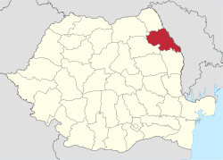
Iași County
| Iași County Județul Iași | ||
|---|---|---|
| County | ||
| ||
 | ||
| Coordinates: 47°15′N 27°19′E / 47.25°N 27.31°ECoordinates: 47°15′N 27°19′E / 47.25°N 27.31°E | ||
| Country | Romania | |
| Development region | Nord-Est | |
| Historical region | Moldavia | |
| Capital | Iași | |
| Area | ||
| • Total | 5,476 km2 (2,114 sq mi) | |
| Area rank | 23rd | |
| Population (2011) | ||
| • Total | 772,348 | |
| • Rank | 2nd | |
| • Density | 140/km2 (370/sq mi) | |
| Telephone code | (+40) 232 or (+40) 332[1] | |
| ISO 3166 code | RO-IS | |
| Website |
County Council Prefecture | |

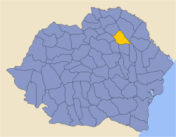
Iași County (Romanian pronunciation: [ˈjaʃʲ]) is a county (județ) of Romania, in Moldavia, with the administrative seat at Iași. It is the most populous county in Romania, after the Municipality of Bucharest (which has the same administrative level as that of a county).
Geography
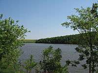
This county has a total area of 5,476 km². It lies on a plain between the Siret River and the Prut River. Two other rivers run through the county: the Bahlui River (on the banks of which lies the city of Iași) and the Jijia River.
Neighbours
- Republic of Moldova to the east - Ungheni District.
- Neamț County to the west.
- Botoșani County and Suceava County to the northwest.
- Vaslui County to the south.
Demographics
As of 20 October 2011 census, Iași County had a population of 772,348.[2] On the other hand, according to the 2012 data provided by the County Population Register Service, the total registered population of the county is as high as 873,662 people.[3]
The population of Iași County today is nearly double what it was sixty years ago.
| Year | County population[5] |
|---|---|
| 1948 | 431,586 |
| 1956 | |
| 1966 | |
| 1977 | |
| 1992 | |
| 2002 | |
| 2011 |
County government
The Iași County Council, elected at the 2016 local government elections, is made up of 37 counselors, with the following party composition:[6]
| Party | Seats | Current County Council | |||||||||||||||||
|---|---|---|---|---|---|---|---|---|---|---|---|---|---|---|---|---|---|---|---|
| Social Democratic Party | 17 | ||||||||||||||||||
| National Liberal Party | 12 | ||||||||||||||||||
| People's Movement Party | 5 | ||||||||||||||||||
| Alliance of Liberals and Democrats | 3 | ||||||||||||||||||
Economy
This county is predominantly agricultural, due to its topography. Industry is concentrated in the cities. The principal industries are:
- Software
- Pharmaceuticals
- Automotive
- Metallurgy and heavy-equipment manufacturing
- Electronics & Electrotechnics
- Textiles
- Food production
Tourism
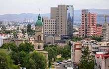
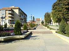
City of Iași is the most important city in Moldavia and one of the most important social, cultural and business centres in Romania. It has the oldest University in the country, and, until the formation of the United Principalities, it was the capital of Moldavia.
Some of the tourist destinations in the county:
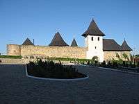
- City of Iași and its environs (the Seven hills of Iași);
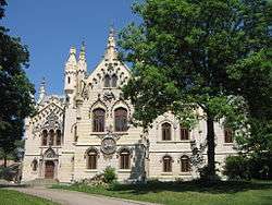
- Alexandru Ioan Cuza Memorial Palace in Ruginoasa;
- Cucuteni - Neolithic archeological site;
- Cotnari and Bohotin vineyards;
- Museum of Vineyard and Wine in Hârlău;
- Hadâmbu and Dobrovăț Monasteries;
- Miclăușeni Castle and Monastery;
- Vasile Alecsandri Memorial House in Mircești;
- Constantin Negruzzi Museum in Hermeziu;
- Cezar Petrescu Museum in Cotnari;
- City of Pașcani, and towns of Târgu Frumos and Hârlău;
- Strunga health resort.
Communities

Iași County has 2 municipalities, 3 towns, and 93 communes
- Municipalities (as of 2011 census)
- Towns
- Communes
- Alexandru Ioan Cuza
- Andrieșeni
- Aroneanu
- Balș
- Bălțați
- Bârnova
- Belcești
- Bivolari
- Brăești
- Butea
- Ceplenița
- Ciohorăni
- Ciortești
- Ciurea
- Coarnele Caprei
- Comarna
- Costești
- Costuleni
- Cotnari
- Cozmești
- Cristești
- Cucuteni
- Dagâța
- Deleni
- Dobrovăț
- Dolhești
- Drăgușeni
- Dumești
- Erbiceni
- Fântânele
- Focuri
- Golăiești
- Gorban
- Grajduri
- Gropnița
- Grozești
- Hălăucești
- Hărmănești
- Heleșteni
- Holboca
- Horlești
- Ion Neculce
- Ipatele
- Lespezi
- Lețcani
- Lungani
- Mădârjac
- Mircești
- Mironeasa
- Miroslava
- Miroslovești
- Mogoșești
- Mogoșești-Siret
- Moșna
- Moțca
- Movileni
- Oțeleni
- Plugari
- Popești
- Popricani
- Prisăcani
- Probota
- Răchiteni
- Răducăneni
- Rediu
- Românești
- Roșcani
- Ruginoasa
- Scânteia
- Schitu Duca
- Scobinți
- Sinești
- Sirețel
- Stolniceni-Prăjescu
- Strunga
- Șcheia
- Șipote
- Tansa
- Tătăruși
- Țibana
- Țibănești
- Țigănași
- Todirești
- Tomești
- Trifești
- Țuțora
- Ungheni
- Valea Lupului
- Valea Seacă
- Vânători
- Victoria
- Vlădeni
- Voinești
Historical county
| Județul Iași | ||
|---|---|---|
| County (Județ) | ||
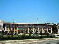
 The building of the prefecture of Iaşi County from the interwar period, now an arts university. | ||
| ||
 | ||
| Country |
| |
| Historic region | Moldavia | |
| Capital city (Reședință de județ) | Iași | |
| Area | ||
| • Total | 3,227 km2 (1,246 sq mi) | |
| Population (1930) | ||
| • Total | 275,796 | |
| • Density | 85/km2 (220/sq mi) | |
| Time zone | UTC+2 (EET) | |
| • Summer (DST) | UTC+3 (EEST) | |
The county was located in the northeastern part of Greater Romania, in the northeast of the region of Moldavia. Today, most of the territory of the former county is part of the current Iași County. In the eastern part of the county, the county included a part of the left bank of the Prut River, now in the territory of the Republic of Moldova. It was bordered to the north by the counties of Botoșani and Bălți, to the east by Lăpușna County, to the south by the counties of Fălciu and Vaslui, and to the west by the counties of Roman and Baia.
Administration
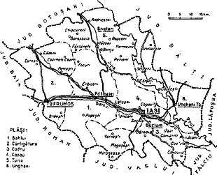
In 1938, the county was divided into six districts (plăṣi):[8]
- Plasa Bahlui, headquartered at Podu Iloaiei
- Plasa Cârligătura, headquartered at Târgu Frumos
- Plasa Codru, headquartered at Buciumii (at that time a commune, now Bucium District in the city of Iași)[9]
- Plasa Copou, headquartered at Iași
- Plasa Turia, headquartered at Șipotele
- Plasa Ungheni, headquartered at Ungheni-Târg, now the city of Ungheni in the Republic of Moldova
Iasi County included two urban localities: Iaşi (county seat) and urban commune Târgu Frumos, located at the western border of the county.
Population
According to the 1930 census data, the county population was 275,796 inhabitants, 81.6% Romanians, 14.6% Jews, 0.6% Russians, 0.5% Hungarians, 0.4% Germans, as well as other minorities.[10] From the religious point of view, the population was 82.0% Eastern Orthodox, 14.9% Jewish, 2.3% Roman Catholic, as well as other minorities.
Urban population
In 1930, the county's urban population was 107,804 inhabitants, 102,872 in Iaşi and 4,932 in Târgu Frumos, comprising 30.8% Romanians, 33.6% Jews, 0.9% Germans, 0.9% Russians, as well as other minorities. In the urban area, languages were Romanian (72.5%), followed by Yiddish (22.2%), Russian (1.8%), German (0.9%), as well as other minorities.[10] From the religious point of view, the urban population was composed of Eastern Orthodox (61.4%), Jewish (34.4%), Roman Catholic (3.0%), as well as other minorities.
References
| Wikimedia Commons has media related to Iași County. |
- ↑ The number used depends on the numbering system employed by the phone companies on the market.
- ↑ "Population at 20 October 2011" (in Romanian). INSSE. Retrieved 28 March 2016.
- ↑ "Unul din 25 de ieșeni nu deține acte de identitate" (in Romanian). ziarulevenimentul.ro. 2013-02-14. Retrieved 2013-02-15.
- ↑ National Institute of Statistics, "Populația după etnie" Archived 2009-08-16 at the Wayback Machine.
- ↑ National Institute of Statistics, "Populația la recensămintele din anii 1948, 1956, 1966, 1977, 1992 și 2002" Archived 2006-09-22 at the Wayback Machine.
- ↑ "Mandate de CJ pe judete si competitori" (in Romanian). Biroul Electoral Central. 10 June 2016. Retrieved 16 June 2016.
- ↑ "Population on 1 January by age groups and sex - functional urban areas". Eurostat. Retrieved 8 June 2016.
- ↑ Portretul României Interbelice - Județul Iași
- ↑ Școala Gimnazială „Veronica Micle” din Iași
- 1 2 Recensământul general al populației României din 29 decemvrie 1930, Vol. II, pag. 246-247