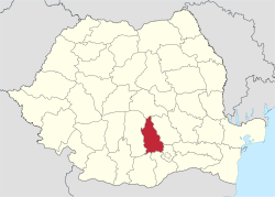
Dâmbovița County
| Dâmbovița County Județul Dâmbovița | ||
|---|---|---|
| County | ||
| ||
 | ||
| Coordinates: 44°53′N 25°28′E / 44.89°N 25.47°ECoordinates: 44°53′N 25°28′E / 44.89°N 25.47°E | ||
| Country |
| |
| Development region1 | Sud | |
| Historic region | Muntenia | |
| Capital city (Reședință de județ) | Târgoviște | |
| Government | ||
| • Type | County Board | |
| • President of the County Board | Gheorghe Ana | |
| • Prefect2 | Aurelian Popa | |
| Area | ||
| • Total | 4,054 km2 (1,565 sq mi) | |
| Area rank | 37th in Romania | |
| Population (2011 census[1]) | ||
| • Total | 518,745 | |
| • Rank | 15th in Romania | |
| • Density | 127/km2 (330/sq mi) | |
| Time zone | UTC+2 (EET) | |
| • Summer (DST) | UTC+3 (EEST) | |
| Postal Code | 13wxyz3 | |
| Area code(s) | +40 x454 | |
| Car Plates | DB5 | |
| GDP | US$ 3.71 billion (2008) | |
| GDP/capita | US$ 6,831 (2008) | |
| Website |
County Board County Prefecture | |
|
1The development regions of Romania have no administrative role. They were formed just to attract funds from the European Union 2 as of 2007, the Prefect is not a politician, but a public functionary. He (or she) is not allowed to be a member of a political party, and is banned to have any political activity in the first six months after the resignation (or exclusion) from the public functionary corps 3w, x, y, and z are digits that indicate the city, the street, part of the street, or even the building of the address 4x is a digit indicating the operator: 2 for the former national operator, Romtelecom, and 3 for the other ground telephone networks 5used on both the plates of the vehicles that operate only in the county limits (like utility vehicles, ATVs, etc.), and the ones used outside the county | ||

Dâmbovița County (also spelt Dîmbovița, Romanian pronunciation: [ˈdɨmbovit͡sa] (![]()
Demographics
In 2011, it had a population of 518,745 and the population density was 127/km². It is one of the most densely populated counties in Romania.
- Romanians – 96%[2]
- Roma (Gypsies), others.
| Year | County population[1][3] |
|---|---|
| 1948 | 409,272 |
| 1956 | |
| 1966 | |
| 1977 | |
| 1992 | |
| 2002 | |
| 2011 |
Name
The county is named after the Dâmbovița River, which is a name of Slavic origin, derived from Дъб, dămb, meaning "oak", as it once flowed through the oak forests of the Wallachian Plain.[4]
Geography
Dâmbovița county has a total area of 4,054 km².
The county's landscape has three main forms. In the north there are mountains from the Southern Carpathians group – the Bucegi Mountains and the Leaotă Mountains. In the center there are the sub-Carpathian hills and the southern area is part of the Romanian Plain.
The county's main river gives it its name: the Dâmbovița River. Also the Ialomița River flows in the county's northern and eastern regions, while the Argeș River flows in the south.
Neighbouring counties
- Ilfov County and Prahova County in the East.
- Argeș County in the West.
- Brașov County in the North.
- Teleorman County and Giurgiu County in the South.
Economy
One of the biggest steel factories in Romania is located In Târgoviște. Also, oil is extracted and refined the county.
The predominant industries in the county are:
- Metallurgical industry.
- Oil extraction equipment.
- Food industry.
- Home appliances.
- Textile industry.
- Chemical industry.
- Construction materials industry.
Tourism
The main tourist destinations are:
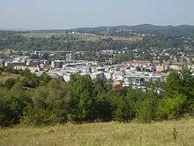
- The city of Târgoviște – the ancient capital of Muntenia.
- The Pucioasa Resort.
- The Ialomița River Valley – Peștera Ialomicioarei.
Trivia
- Glod, a small village in this area, was used to represent Kazakhstan in the filming of the mockumentary movie Borat: Cultural Learnings of America for Make Benefit Glorious Nation of Kazakhstan.
Politics
The Dâmbovița County Council, elected at the 2016 local government elections, is made up of 35 counselors, with the following party composition:[5]
| Party | Seats | Current County Council | ||||||||||||||||||||||
|---|---|---|---|---|---|---|---|---|---|---|---|---|---|---|---|---|---|---|---|---|---|---|---|---|
| Social Democratic Party | 22 | |||||||||||||||||||||||
| National Liberal Party | 13 | |||||||||||||||||||||||
Administrative divisions

Dâmbovița County 2 municipalities, 5 towns and 82 communes
- Municipalities
- Moreni
- Târgoviște – county seat; population: 79,610 (as of 2011)
- Towns
- Communes
- Aninoasa
- Băleni
- Bărbulețu
- Bezdead
- Bilciurești
- Braniștea
- Brănești
- Brezoaele
- Buciumeni
- Bucșani
- Butimanu
- Cândești
- Ciocănești
- Cobia
- Cojasca
- Comișani
- Conțești
- Corbii Mari
- Cornățelu
- Cornești
- Costeștii din Vale
- Crângurile
- Crevedia
- Dărmănești
- Dobra
- Doicești
- Dragodana
- Dragomirești
- Finta
- Glodeni
- Gura Foii
- Gura Ocniței
- Gura Șuții
- Hulubești
- I. L. Caragiale
- Iedera
- Lucieni
- Ludești
- Lungulețu
- Malu cu Flori
- Mănești
- Mătăsaru
- Mogoșani
- Moroeni
- Morteni
- Moțăieni
- Niculești
- Nucet
- Ocnița
- Odobești
- Perșinari
- Pietrari
- Petrești
- Pietroșița
- Poiana
- Potlogi
- Produlești
- Pucheni
- Raciu
- Răscăeți
- Răzvad
- Râu Alb
- Runcu
- Sălcioara
- Slobozia Moară
- Șelaru, Dâmbovița
- Șotânga
- Tărtășești
- Tătărani
- Uliești
- Ulmi
- Văcărești
- Valea Lungă
- Valea Mare
- Văleni-Dâmbovița
- Vârfuri
- Vișina
- Vișinești
- Vlădeni
- Voinești
- Vulcana-Băi
- Vulcana-Pandele
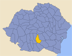
Historical county
| Județul Dâmbovița | ||
|---|---|---|
| County (Județ) | ||
.JPG) The Dâmbovița County prefecture building from the interwar period, now an art museum. | ||
| ||
 | ||
| Country |
| |
| Historic region | Muntenia | |
| Capital city (Reședință de județ) | Târgoviște | |
| Area | ||
| • Total | 3,440 km2 (1,330 sq mi) | |
| Population (1930) | ||
| • Total | 310,310 | |
| • Density | 90/km2 (230/sq mi) | |
| Time zone | UTC+2 (EET) | |
| • Summer (DST) | UTC+3 (EEST) | |
Historically, the county was located in the central-southern part of Greater Romania, in the northern part of the historical region of Muntenia. The county included a large part of the present county. It was bordered to the west by the counties of Muscel and Arges, to the north by Braşov County, to the east by Prahova County, and to the south by the counties of Ilfov and Vlașca.
Administration
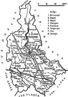
The county was originally divided administratively into six districts (plăṣi):[6]
- Plasa Finta, headquartered at Finta
- Plasa Găești, headquartered at Găești
- Plasa Pucioasa, headquartered at Pucioasa
- Plasa Târgoviște, headquartered at Târgoviște
- Plasa Titu, headquartered at Titu
- Plasa Voinești, headquartered at Voinești
Subsequently, the territory of the county was reorganized into eight districts by the abolition of Plasa Finta and the establishment of three new districts in its place:
- Plasa Bilciurești, headquartered at Bilciurești
- Plasa Bogați, headquartered at Bogați
- Plasa Ghergani, headquartered at Ghergani
Population
According to the 1930 census data, the county population was 309,676 inhabitants, ethnically divided as follows: 96.9% Romanians, 2.1% Romanies, 0.2% Jews, 0.2% Hungarians, 0.1% Germans, as well as other minorities. From the religious point of view, the population was 98.9% Eastern Orthodox, 0.3% Roman Catholic, 0.3% Jewish, 0.1% Adventist, 0.1% Greek Catholic, as well as other minorities.
Urban population
In 1930, the county's urban population was 33,398 inhabitants, comprising 63.2% Romanians, 2.0% Jews, 1.3% Romanies, 1.2% Hungarians, 0.5% Greeks, as well as other minorities. From the religious point of view, the urban population was composed of 94.8% Eastern Orthodox, 2.1% Jewish, 1.5% Roman Catholic, 0.6% Greek Catholic, 0.3% Calvinist, 0.3% Lutheran, as well as other minorities.
References
| Wikimedia Commons has media related to Dâmbovița County. |
- 1 2 "Population at 20 October 2011" (in Romanian). INSSE. 5 July 2013. Retrieved 9 July 2013.
- ↑ National Institute of Statistics, "Populația după etnie"
- ↑ National Institute of Statistics, "Populația la recensămintele din anii 1948, 1956, 1966, 1977, 1992 și 2002" Archived 22 September 2006 at the Wayback Machine.
- ↑ Constantin C. Giurescu, Istoria Bucureștilor. Din cele mai vechi timpuri pînă în zilele noastre, Bucharest, 1966, p.38.
- ↑ "Mandate de CJ pe judete si competitori" (in Romanian). Biroul Electoral Central. 10 June 2016. Retrieved 16 June 2016.
- ↑ Portretul României Interbelice - Județul Dâmbovița