Alba County
| Alba County Județul Alba | |||
|---|---|---|---|
| County | |||
| |||
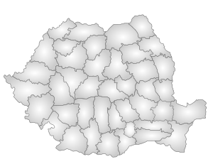
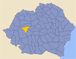
 Location of Alba County in Romania | |||
| Country |
| ||
| Development region1 | Centru | ||
| Historic region | Transylvania | ||
| County seat | Alba Iulia | ||
| Government | |||
| • Type | County Board | ||
| • President of the County Board | Ion Dumitrel (PDL) | ||
| • Prefect2 | Dan Simedru-Coriolan | ||
| Area | |||
| • Total | 6,242 km2 (2,410 sq mi) | ||
| Area rank | 16th in Romania | ||
| Population | |||
| • Total | 327,224 | ||
| • Rank | 29th in Romania | ||
| • Density | 52/km2 (140/sq mi) | ||
| Time zone | UTC+2 (EET) | ||
| • Summer (DST) | UTC+3 (EEST) | ||
| Postal Code | 51wxyz3 | ||
| Area code(s) | +40 x584 | ||
| Car Plates | AB5 | ||
| GDP | US$ 3.77 billion (2008) | ||
| GDP/capita | US$ 9,842 (2008) | ||
| Website |
County Board County Prefecture | ||
|
1The developing regions of Romania have no administrative role. They were formed to attract funds from the European Union 2 as of 2007, the Prefect is not a politician, but a public functionary. He or she is not allowed to be a member of a political party, and is banned to have any political activity in the first six months after the resignation (or exclusion) from the public functionaries corp 3w, x, y, and z are digits that indicate the city, the street, part of the street, or eaven the building of the address 4x is a digit indicating the operator: 2 for the former national operator, Romtelecom, and 3 for the other ground telephone networks 5used on both the plates of the vehicles that operate only in the county limits (like utilitary vehicles & ATVs, etc.) and the ones used outside the county | |||

Alba County (Romanian pronunciation: [ˈalba]) is a county (județ) of Romania, in Transylvania, its capital city being Alba-Iulia with a population of 63,536.[1]
Name
"Alba", meaning "white" in Latin and Romanian, is derived from the name of the city of Alba Iulia. In Hungarian, the county is known as Fehér megye (fehér also meaning white), and in German as Kreis Karlsburg.
Demographics
In October 31, 2011, it had a population of 327,224 and the population density was 52/km².
- Romanians - 89.9%[2]
- Hungarians - 4.8%
- Romani - 4.7%
- Germans (Transylvanian Saxons) - 0.2%
| Year | County population[3] |
|---|---|
| 1948 | 361,062 |
| 1956 | 370,800 |
| 1966 | 382,786 |
| 1977 | 409,634 |
| 1992 | 414,227 |
| 2002 | 382,747 |
| 2011 | 327,224 |
Geography
This county has a total area of 6,242 km², with mountains occupying about 59% of its surface.
In the northwestern part there are the Apuseni Mountains, in the southern part there is the northeastern side of the Parâng group - Șureanu and Cindrel Mountains. In the east there is the Transylvanian Plateau with deep but wide valleys. The three main elements are separated by the Mureș River valley.
The main rivers are the Mureș River and its tributaries, the Târnava, the Sebeș and the Arieș.
Neighbors
Economy
The predominant industries in the county are:
- Food industry.
- Textile industry.
- Wood industry.
- Mechanical components.
- Paper and packaging materials industry.
- Chemical industry.
The mineral resources exploited in Alba county are metals (gold, silver, copper), salt and construction materials: marble, granite, etc.
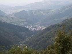
Tourist attractions
The main tourist attractions in the county are:
- The city of Alba Iulia.
- The Apuseni Mountains.
- Scărișoara Karst Complex.
- Maidens' Fair on the Găina Mountain.
- "The Hill With Snails" west of Vidra.
- Barren Detunata and Shaggy Detunata (Detunatele)
- The Câlnic Castle and the Castle of Gârbova.
- The Towns and Churches of Sebeș and Aiud.
- The Ocna Mureș Resort.
- The Țara Moților ethnographical area. Situated in the Apuseni Mountains, Țara Moților is a region with strong Romanian traditions.
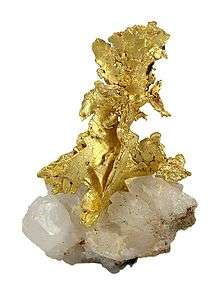
- Rosia Montana Mining Cultural Landscape - Mining began 2000 years ago on Mt. Kirnik, with well-preserved Roman galleries. A Canadian company attempted an open-pit mine, but abandoned the project around 2007. Roșia Montană is a famous locality among mineral collectors for fine native gold specimens.[4][5]
Politics
The Alba County Council, elected at the 2016 local government elections, is made up of 33 counselors, with the following party composition:[6]
| Party | Seats | Current County Council | |||||||||||||||||||
|---|---|---|---|---|---|---|---|---|---|---|---|---|---|---|---|---|---|---|---|---|---|
| National Liberal Party | 19 | ||||||||||||||||||||
| Social Democratic Party | 9 | ||||||||||||||||||||
| Alliance of Liberals and Democrats | 3 | ||||||||||||||||||||
| People's Movement Party | 2 | ||||||||||||||||||||
Administrative divisions
Alba County has 4 municipalities, 7 towns and 67 communes.
- Municipalities
- Aiud
- Alba Iulia - county seat; 58,761 (as of 2011)
- Blaj
- Sebeș
- Towns
- Communes
- Albac
- Almașu Mare
- Arieșeni
- Avram Iancu
- Berghin
- Bistra
- Blandiana
- Bucerdea Grânoasă
- Bucium
- Câlnic
- Cenade
- Cergău
- Ceru-Băcăinți
- Cetatea de Baltă
- Ciugud
- Ciuruleasa
- Crăciunelu de Jos
- Cricău
- Cut
- Daia Româna
- Doștat
- Fărău
- Galda de Jos
- Gârbova
- Gârda de Sus
- Hopârta
- Horea
- Ighiu
- Întregalde
- Jidvei
- Livezile
- Lopadea Nouă
- Lunca Mureşului
- Lupșa
- Meteș
- Mihalț
- Mirăslău
- Mogoș
- Noșlac
- Ocoliș
- Ohaba
- Pianu
- Poiana Vadului
- Ponor
- Poșaga
- Rădești
- Râmeț
- Rimetea
- Roșia de Secaș
- Roșia Montană
- Sălciua
- Săliștea
- Sâncel
- Sântimbru
- Săsciori
- Scărișoara
- Șibot
- Sohodol
- Șona
- Șpring
- Stremț
- Șugag
- Unirea
- Vadu Moților
- Valea Lungă
- Vidra
- Vințu de Jos
Historical county
| Județul Alba | ||
|---|---|---|
| County (Județ) | ||
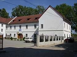 The Alba County Prefecture building of the interwar period, currently the headquarters of the Alba County Schools Inspectorate. | ||
| ||
 | ||
| Country |
| |
| Historic region | Transylvania | |
| Capital city (Reședință de județ) | Alba-Iulia | |
| Established | 1925 | |
| Area | ||
| • Total | 2,433 km2 (939 sq mi) | |
| Population (1930) | ||
| • Total | 213,795 | |
| • Density | 88/km2 (230/sq mi) | |
| Time zone | UTC+2 (EET) | |
| • Summer (DST) | UTC+3 (EEST) | |
Historically, Alba de Jos county was located in the central-western part of Greater Romania, in the southwestern part of Transylvania with a territory identical with the old Alsó-Fehér County of Hungary. After the administrative unification law in 1925, the name of the county changed to Alba County and the territory was reorganized. It was bordered on the west by Hunedoara County, to the north by Turda County, and to the east by the counties of Sibiu and Târnava-Mică. Its territory included the central part of the current Alba County.
Administration
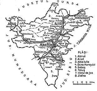
The county originally consisted of seven districts (plăṣi):[7]
- Plasa Abrud (headquarters at Abrud)
- Plasa Aiud (headquarters at Aiud)
- Plasa Ighiu (headquarters at Ighiu)
- Plasa Ocna Mureș (headquarters at Ocna Mureș)
- Plasa Sebeș (headquarters at Sebeș)
- Plasa Teiuș (headquarters at Teiuș)
- Plasa Vințu de Jos (headquarters at Vințu de Jos)
Subsequently, Plasa Ighiu was abolished and two other districts were established, leaving these:
- Plasa Abrud (seven villages, headquarters at Abrud)
- Plasa Aiud (thirty-three villages, headquarters at Aiud)
- Plasa Alba Iulia (eighteen villages, headquarters at Alba Iulia)
- Plasa Ocna Mureș (twenty-one villages, headquarters at Ocna Mureș)
- Plasa Sebeș (twenty-one villages, headquarters at Sebeș)
- Plasa Teiuș (twenty villages, headquarters at Teiuș)
- Plasa Vințu de Jos (thirteen villages, headquarters at Vințu de Jos)
- Plasa Zlatna (eighteen villages, headquarters at Zlatna)
There were four towns: Alba-Iulia, Abrud, Aiud and Sebeș.
Population
According to the census data of 1930, the county's population was 212,749, of which 81.5% were Romanians, 11.3% Hungarians, 3.6% Germans, 1.8% Romanies, 1.4% Jews, as well as other minorities. In the religious aspect, the population consisted of 50.1% Eastern Orthodox, 31.6% Greek Catholics, 7.5% Reformed (Calvinists), 3.4% Roman Catholics, 3.3% Evangelical (Lutherans), 1.2% Unitarians, and other minorities.[8]
Urban population
In 1930, the urban population of the county was 33,365, of which 58.8% were Romanians, 23.0% Hungarians, 8.2% Germans, 6.2% Jews, 1.6% Romanies, as well as other minorities. From the religious point of view, the urban population was made up of 38.3% Eastern Orthodox, 21.4% Greek Catholic, 14.7% Reformed (Calvinist), 7.2% Evangelical (Lutheran), 6.5% Jewish, as well as other minorities.[8]
After 1938
After the 1938 Administrative and Constitutional Reform, this county merged with the counties of Ciuc, Odorhei, Sibiu, Târnava Mare, Târnava Micǎ to form Ținutul Mureș. The county was re-established in 1940, but dissolved again in 1950. It was re-established in 1968 in its current borders.
People
Notable natives include:
References
| Wikimedia Commons has media related to Alba County. |
| Wikimedia Commons has media related to Interwar Alba County. |
- ↑ "Archived copy" (PDF). Archived from the original (PDF) on 2013-04-18. Retrieved 2012-03-26.
- ↑ "COMUNICAT DE PRESĂ : 2 februarie 2012 privind rezultatele provizorii ale Recensământului Populaţiei şi Locuinţelor – 2011" (PDF). Recensamantromania.ro. Retrieved 11 April 2018.
- ↑ National Institute of Statistics, "Populaţia la recensămintele din anii 1948, 1956, 1966, 1977, 1992, 2002 şi 2011" Archived 2006-09-22 at the Wayback Machine.
- ↑ "Roşia Montană (Verespatak; Vöröspatak; Goldbach), Roşia Montanã Commune, Alba Co., Romania". www.mindat.org. Retrieved 5 April 2018.
- ↑ Centre, UNESCO World Heritage. "Roșia Montană Mining Cultural Landscape - UNESCO World Heritage Centre". whc.unesco.org. Retrieved 5 April 2018.
- ↑ "Mandate de CJ pe judete si competitori" (in Romanian). Biroul Electoral Central. 10 June 2016. Retrieved 16 June 2016.
- ↑ Portretul României Interbelice - Județul Alba
- 1 2 Recensământul general al populației României din 29 decemvrie 1930, Vol. II, pp. 522-524
External links
| Wikivoyage has a travel guide for Alba County. |
- (in Romanian) Alba County on memoria.ro