Phước Long, Bình Phước
| Phước Long Thị xã Phước Long | |
|---|---|
| District-level town (Class-4) | |
|
| |
| Country |
|
| Region | Southeast |
| Province | Bình Phước |
| Area | |
| • Total | 45.88 sq mi (118.83 km2) |
| Population (2009) | |
| • Total | 50,019 |
| • Density | 1,100/sq mi (420/km2) |
| Time zone | UTC+07:00 (Indochina Time) |
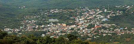
Phước Long is a district-level town in Bình Phước Province, in the Southeast region of Vietnam on the border with Cambodia. It was the site of the Battle of Phước Long, a decisive battle during the Vietnam War.[1]
The current administrative unit was established in 2009 from part of old Phước Long District, Thác Mơ township and Phước Bình township. It covers 118,83 km2 and has a population of 50,019 as of 2009.[2] Bù Gia Mập District was established from the other part of old Phước Long District.
The town has seven subdivisions, including Long Thủy, Thác Mơ, Sơn Giang, Phước Bình, Long Phước, and communes of Long Giang and Phước Tín.
It borders with Bù Đăng District in the east, Bù Gia Mập District in the north, west and south.
Climate
| Climate data for Phước Long, Bình Phước | |||||||||||||
|---|---|---|---|---|---|---|---|---|---|---|---|---|---|
| Month | Jan | Feb | Mar | Apr | May | Jun | Jul | Aug | Sep | Oct | Nov | Dec | Year |
| Record high °C (°F) | 35.4 (95.7) |
38.0 (100.4) |
38.4 (101.1) |
38.5 (101.3) |
38.0 (100.4) |
43.4 (110.1) |
34.9 (94.8) |
36.0 (96.8) |
34.3 (93.7) |
36.0 (96.8) |
34.7 (94.5) |
35.2 (95.4) |
43.4 (110.1) |
| Average high °C (°F) | 31.7 (89.1) |
33.2 (91.8) |
34.6 (94.3) |
34.5 (94.1) |
33.2 (91.8) |
31.1 (88) |
30.6 (87.1) |
30.2 (86.4) |
30.4 (86.7) |
30.5 (86.9) |
30.9 (87.6) |
30.6 (87.1) |
31.8 (89.2) |
| Daily mean °C (°F) | 24.1 (75.4) |
25.3 (77.5) |
26.9 (80.4) |
27.5 (81.5) |
27.0 (80.6) |
26.0 (78.8) |
25.5 (77.9) |
25.3 (77.5) |
25.2 (77.4) |
25.0 (77) |
24.7 (76.5) |
23.7 (74.7) |
25.5 (77.9) |
| Average low °C (°F) | 18.8 (65.8) |
19.7 (67.5) |
21.3 (70.3) |
22.9 (73.2) |
23.4 (74.1) |
23.1 (73.6) |
22.8 (73) |
22.8 (73) |
22.6 (72.7) |
21.9 (71.4) |
20.6 (69.1) |
19.0 (66.2) |
21.6 (70.9) |
| Record low °C (°F) | 13.0 (55.4) |
14.6 (58.3) |
15.0 (59) |
15.0 (59) |
19.8 (67.6) |
17.1 (62.8) |
15.4 (59.7) |
19.9 (67.8) |
19.9 (67.8) |
16.5 (61.7) |
13.2 (55.8) |
13.0 (55.4) |
13.0 (55.4) |
| Average precipitation mm (inches) | 14 (0.55) |
16 (0.63) |
41 (1.61) |
121 (4.76) |
290 (11.42) |
382 (15.04) |
401 (15.79) |
462 (18.19) |
468 (18.43) |
322 (12.68) |
119 (4.69) |
31 (1.22) |
2,665 (104.92) |
| Average precipitation days | 2.0 | 1.7 | 4.7 | 10.8 | 18.9 | 21.6 | 23.8 | 24.5 | 24.2 | 20.9 | 10.4 | 3.9 | 167.3 |
| Average relative humidity (%) | 71.3 | 69.1 | 69.5 | 73.6 | 81.4 | 85.3 | 87.3 | 88.8 | 88.7 | 86.8 | 80.4 | 74.8 | 79.8 |
| Mean monthly sunshine hours | 267 | 248 | 262 | 238 | 216 | 174 | 168 | 154 | 150 | 186 | 215 | 242 | 2,521 |
| Source: Vietnam Institute for Building Science and Technology[3] | |||||||||||||
References
- ↑ Spencer C. Tucker Encyclopedia of the Vietnam War: A Political, Social, and Military History Oxford University Press
- ↑ Vietnam Government Web Portal
- ↑ "Vietnam Building Code Natural Physical & Climatic Data for Construction" (PDF) (in Vietnamese). Vietnam Institute for Building Science and Technology. Archived from the original (PDF) on 22 July 2018. Retrieved 23 July 2018.
| Ho Chi Minh City | 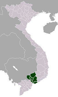 | |
|---|---|---|
| Bà Rịa-Vũng Tàu Province | ||
| Bình Dương Province |
| |
| Bình Phước Province |
| |
| Đồng Nai Province | ||
| Tây Ninh Province | ||
※ denotes provincial seat. | ||
| District-level towns |
|  |
|---|---|---|
| Districts | ||
This article is issued from
Wikipedia.
The text is licensed under Creative Commons - Attribution - Sharealike.
Additional terms may apply for the media files.