Hà Tiên
| Hà Tiên Thành phố Hà Tiên | |
|---|---|
| Provincial city (Class-3) | |
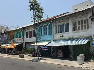 Hà Tiên town square | |
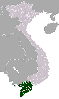
 Hà Tiên Location in Vietnam | |
| Coordinates: 10°23′N 104°29′E / 10.383°N 104.483°E | |
| Country | Vietnam |
| Admin. division | Kiên Giang Province |
| Population (2002) | |
| • Total | 39,957 |
Hà Tiên (Chinese: 河僊,河仙) is a district-level town of Kiên Giang Province, Mekong Delta in Vietnam. Area: 8,851.5 ha, population (2002): 39,957. The town borders Cambodia to the west. Hà Tiên is a popular tourist site of the region thanks to its beautiful beaches and landscapes.
History
In 1829-published Atlas Universel by Pierre M. Lapie, this territory was named as Cancao ou Pontiamo (lit : "Cảng-khẩu or Phương-thành"). Some Modern Chinese and Vietnamese documents called the area the Kingdom of Hatien (河仙王國).[1]
- Pre-1680 : Akadra (Ptolemy's world map) of Nokor Phnom, Banteay Meas District (ស្រុកបន្ទាយមាស ; lit : "golden ramparts") of Cambodia, referred to the bamboo fortifications once used about the town. Many works incorrectly referred to Banteay Meas District as "Panthaimas", the early name of the district in which it was located. It was variously spelled as Panday-mas (in Khmer), Ponteamass (in English), Fong-sing (芳城), Phủ Sài-mạt (in Annamese), Phutthaimat (พุทไธมาศ) or Banthaimat (บันทายมาศ), Ponthiamas or Pontheaymas (in French), Pontiano (in Robert's Map, 1751), Pontiamo (in Lapie's Map, 1829), Panthai-mas, Bantaimas, Pontiamas, Pontaimas, Bantay-mas, Banteay M'eas, Pontiamas, Pontiamasse, Po-taimat, and infinite other variations.[2]
- About 1680 : Góng-háu gwok (港口國 / pronunciation : Cắn-khẩu quấc, Cắn-kháo quấc, Cắn-cáo quấc...). In international script as Cancao or Cancar,[3] Khmer language Peam (ពាម / "river mouth") and ancient Annamese Máng-khảm or Giang-thành[4] (江城), international Manscape.
- 1724 : Long-hồ dinh (龍湖營 / Long-hồ barrack) of Nam Hà. Long-hồ is the Annamese pronunciation of Góng-háu.[5]
- 1735 : Hà-tiên trấn (河僊镇[6] / Town of River Fairy) with one military governor (ឧកញ៉ា / Uknhea). Popular name in old world maps as Hà-tiên quốc (河仙國).
- 1832 : Hà-tiên tỉnh (河仙省[7] / Province of River Fairy) of the Nguyễn dynasty.
- 1956 : Hà Tiên (河仙郡 / Quận Hà-tiên) and Phú Quốc (富國郡 / Quận Phú-quốc) of Kien Giang province (Republic of Vietnam).
- 1975 : Hà Tiên, Phú Quốc and Châu Thành A District (周城A縣 / Huyện Châu-thành A) of Long Châu Hà province (Republic of South Vietnam).
- 1998 : Hà Tiên (河仙市社 / Thị-xã Hà-tiên) of Kien Giang province (Socialist Republic of Vietnam).
- 2014 : Hà Tiên (河仙市 / Thành-phố Hà-tiên) of Kien Giang province (modern Vietnam).
Banteay Meas was through this port that Buddhism is said to have reached Cambodia, brought there by chance when a ship carrying Buddhaghosa was blown there by a storm in 415 AD. Buddhaghosa had with him the famous Emerald Buddha statue, for many centuries thereafter a state treasure of Cambodia and later Laos, until it was carried away by Thai invaders to be placed at its present location in the Wat Phra Kaew in Bangkok.[8]

Cancao was established by a group of a few Hoa people, mostly men who helped the Ming dynasty and were opposed to the Qing dynasty, led by Mạc Kính Cửu. When they arrived in Nam Hà, the Nguyễn-phước rulers ordered the king of Cambodia (then a vassal state of Nam Hà) to grant land to these Hoa people, and made an actively business town. Cochinchinese people gradually arrived there. This town later was merged into Quangnamese territory when Mạc Kính Cửu confirmed its sovereignty to the Nguyễn-phước rulers and he then obtained the title of ruler. The capital was at this time that the name Hà Tiên (河僊 / River Fairy ; international Athien), referring to the guardian deity of the Giang-thành river (江城河), was conferred on the town by ruler Nguyễn Phước Châu.[9]
In Mok clan's territory included 7 casinos : Máng-khảm (Hà Tiên), Lũng-kỳ (Prey Nob District), Cần-bột (Kampot Province), Hương-úc (Kompong Som), Sài-mạt (Banteay Meas District), Linh-quỳnh (Kiri Vong) and Phú-quốc (Koh Tral). Present day, this land correspondings to Cambodian coastal provinces with Vietnamese provinces Kiên Giang (formerly Giang-thành), Hậu Giang, Cà Mau (f. Camao) and Bạc Liêu.
Today, this land correspondings to Cambodian coastal provinces with Vietnamese provinces Kiên Giang (formerly Giang-thành), Cà Mau (f. Camao) and Bạc Liêu.
Economy
Ha Tien is the site of a large cement plant. (The cement plant is actually in Kien Luong, which is 22 km south of Ha Tien). Its history goes back to the Republic of Vietnam (South Vietnam), where it was one of the largest industrial projects when construction was started in April 1961.[10]
Transportation
Buses connect Hà Tiên to the provincial capital Rạch Giá and many other towns in the Mekong Delta-including Châu Đốc,Can Tho,Ca Mau,Vung Tau and Saigon. A border crossing between Hà Tiên and Kampot in Cambodia was opened in 2007. The border is 7 km west of Hà Tiên.Opening hours here are 07.00 to 18.00
Daily fast ferries are available to Phú Quốc island.In the low (wet) season they normally operate twice a day-at approximately 08.00-08.30 and then 13.00-13.30 (Times vary a bit according to tides/weather etc)In the high season they run more frequently,with up to 3 fast boats(Superdong) each making up to 3 crossings every day.The trip takes about 80-90 minutesThere are also now(Sept 2016)4 car ferries operating from Ha Tien to the N/E corner of the island at Bai Thom.These run on demand,not to a fixed schedule,and can start as early as 05.00 and run until 21.00.This takes about 2.5 hours
See also
- Cancao
References
- ↑ 武世營《河仙鎮協鎮鄚氏家譜》,收錄於《嶺南摭怪等史料三種》,231-232頁。戴可來《<嘉定通志>、<鄚氏家譜>中所見17~19世紀初葉的南圻華僑史迹》,附錄於《嶺南摭怪等史料三種》,305頁。鄭懷德《嘉定城通志·疆域志·河仙鎮》,收錄於《嶺南摭怪等史料三種》,152頁。武世營《河仙鎮協鎮鄚氏家譜》,收錄於《嶺南摭怪等史料三種》,232頁。
- ↑ Nicholas Sellers, The Princes of Hà-tiên (1682 - 1867) : the Last of the Philosopher-Princes and the Prelude to the French Conquest of Indochina : a Study of the Independent Rule of the Mạc Dynasty in the Principality of Hà-tiên, and the Establishment of the Empire of Vietnam, Brussels, Thanh-long, 1983, p. 164.
- ↑ Les œuvres complètes de Pierre Poivre, Pierre Poivre, Lyon Public Library, 1797.
- ↑ Đại Nam thực lục, Nguyễn dynasty's Academia Historica, XIX-century.
- ↑ BBC : Japan and naval battles
- ↑ 《大南一统志》河仙省·建置沿革:以所居相傳常有僊人出沒於河上,國因號河僊國。
- ↑ 戴可來《<嘉定通志>、<鄚氏家譜>中所見17~19世紀初葉的南圻華僑史迹》,附錄於《嶺南摭怪等史料三種》,305頁。
- ↑ "轉引自陳慶新《貿易、移殖與文化交流:15-17世紀廣東人與越南》(PDF)" (PDF). Archived from the original (PDF) on 2013-08-27.
- ↑ Introduction of Ha-tien
- ↑ Đặng Phong (2004), Kinh tế Miền Nam Việt nam thời kỳ 1955 - 1975, Nhà xuất bản Khoa học xã hội, Hanoi, page 286
External links
| Wikimedia Commons has media related to Ha Tien. |

Districts of the Mekong River Delta | ||
|---|---|---|
| Cần Thơ city |
|  |
| An Giang Province | ||
| Bạc Liêu Province | ||
| Bến Tre Province | ||
| Cà Mau Province | ||
| Đồng Tháp Province | ||
| Hậu Giang Province |
| |
| Kiên Giang Province | ||
| Long An Province | ||
| Sóc Trăng Province | ||
| Tiền Giang Province |
| |
| Trà Vinh Province | ||
| Vĩnh Long Province | ||
※ denotes provincial seat. | ||