Les Rousses
| Les Rousses | ||
|---|---|---|
| Commune | ||
 | ||
| ||
 Les Rousses Location within Bourgogne-Franche-Comté region  Les Rousses | ||
| Coordinates: 46°29′11″N 6°03′45″E / 46.4864°N 6.0625°ECoordinates: 46°29′11″N 6°03′45″E / 46.4864°N 6.0625°E | ||
| Country | France | |
| Region | Bourgogne-Franche-Comté | |
| Department | Jura | |
| Arrondissement | Saint-Claude | |
| Canton | Morez | |
| Intercommunality | Station des Rousses | |
| Government | ||
| • Mayor (2014–2020) | Bernard Mamet | |
| Area1 | 38.00 km2 (14.67 sq mi) | |
| Population (2013)2 | 3,137 | |
| • Density | 83/km2 (210/sq mi) | |
| Time zone | UTC+1 (CET) | |
| • Summer (DST) | UTC+2 (CEST) | |
| INSEE/Postal code | 39470 /39220 | |
| Elevation | 720–1,300 m (2,360–4,270 ft) | |
|
1 French Land Register data, which excludes lakes, ponds, glaciers > 1 km2 (0.386 sq mi or 247 acres) and river estuaries. 2 Population without double counting: residents of multiple communes (e.g., students and military personnel) only counted once. | ||
.svg.png)
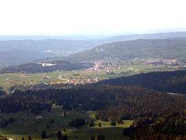
Les Rousses is a commune in the Canton of Morez of Jura department in the Bourgogne-Franche-Comté region in eastern France, on the Swiss border.
The Lac des Rousses is located northeast of the village of Les Rousses beside the road to the village of Bois d'Amont. The Lac de Lamoura is located southwest of the village of Les Rousses beside the road to the village of Lamoura. Other places include the village of Prémanon, and La Cure, the transit point across the Swiss border towards Saint-Cergue.[1]
Population
| Historical population | ||
|---|---|---|
| Year | Pop. | ±% |
| 1793 | 2,501 | — |
| 1806 | 2,159 | −13.7% |
| 1821 | 2,278 | +5.5% |
| 1831 | 2,187 | −4.0% |
| 1841 | 2,017 | −7.8% |
| 1851 | 2,395 | +18.7% |
| 1861 | 2,581 | +7.8% |
| 1872 | 2,527 | −2.1% |
| 1881 | 2,545 | +0.7% |
| 1891 | 2,476 | −2.7% |
| 1901 | 2,195 | −11.3% |
| 1911 | 2,031 | −7.5% |
| 1921 | 1,701 | −16.2% |
| 1931 | 1,571 | −7.6% |
| 1946 | 1,533 | −2.4% |
| 1954 | 1,795 | +17.1% |
| 1962 | 1,731 | −3.6% |
| 1968 | 1,755 | +1.4% |
| 1975 | 2,061 | +17.4% |
| 1982 | 2,331 | +13.1% |
| 1990 | 2,840 | +21.8% |
| 1999 | 2,927 | +3.1% |
| 2006 | 3,018 | +3.1% |
| 2013 | 3,137 | +3.9% |
Tourism
Les Rousses includes part of the Upper Jura Natural Park and Fort des Rousses, an historical fortress that, until 1997, was used as a commando training site. The fortress includes an underground labyrinth used in training, that is open to the public.[2]
Les Rousses has an extensive ski area, especially for cross-country skiing. Many villages have their own runs using a common lift pass.
- Alpine
- Massif du Noirmont
- Massif des Tuffes
- Porte des Jouvencelles
- Porte de la Darbella
- Porte de la Serra
- Porte de la Combe de lac
- Porte de la Giraude
- Nordic
- Secteur de Bellefontaine
- Secteur du Risoux
- Secteur de l'Orbe
- Secteur de la Sambine
- Secteur du Massacre
- Secteur de Longchamois
- Secteur de Lamoura/Serra
See also
References
- ↑ "Map of four villages, Les Rousses". site officiel de la Communauté de communes de la Station des Rousses.
- ↑ "Fort des Rousses - Parc Aventure". site officiel de la Communauté de communes de la Station des Rousses. Archived from the original on 2013-07-26.
External links
- "Les Rousses" from Quid (in French)
- Les Rousses Ski info
| Wikimedia Commons has media related to Les Rousses. |