Dramelay
| Dramelay | ||
|---|---|---|
| Commune | ||
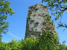 Tower of the chateau | ||
| ||
 Dramelay Location within Bourgogne-Franche-Comté region  Dramelay | ||
| Coordinates: 46°24′27″N 5°32′12″E / 46.4075°N 5.5367°ECoordinates: 46°24′27″N 5°32′12″E / 46.4075°N 5.5367°E | ||
| Country | France | |
| Region | Bourgogne-Franche-Comté | |
| Department | Jura | |
| Arrondissement | Lons-le-Saunier | |
| Canton | Moirans-en-Montagne | |
| Government | ||
| • Mayor (2014–2020) | Philippe Lamard | |
| Area1 | 6.53 km2 (2.52 sq mi) | |
| Population (2012)2 | 35 | |
| • Density | 5.4/km2 (14/sq mi) | |
| Time zone | UTC+1 (CET) | |
| • Summer (DST) | UTC+2 (CEST) | |
| INSEE/Postal code | 39204 /39240 | |
| Elevation | 340–629 m (1,115–2,064 ft) | |
|
1 French Land Register data, which excludes lakes, ponds, glaciers > 1 km2 (0.386 sq mi or 247 acres) and river estuaries. 2 Population without double counting: residents of multiple communes (e.g., students and military personnel) only counted once. | ||

Dramelay is a commune in the Jura department in Franche-Comté in eastern France.
Population
| Historical population | ||
|---|---|---|
| Year | Pop. | ±% |
| 1793 | 276 | — |
| 1806 | 186 | −32.6% |
| 1821 | 144 | −22.6% |
| 1831 | 267 | +85.4% |
| 1841 | 227 | −15.0% |
| 1851 | 199 | −12.3% |
| 1861 | 202 | +1.5% |
| 1872 | 162 | −19.8% |
| 1881 | 151 | −6.8% |
| 1891 | 148 | −2.0% |
| 1901 | 121 | −18.2% |
| 1911 | 86 | −28.9% |
| 1921 | 96 | +11.6% |
| 1931 | 95 | −1.0% |
| 1946 | 72 | −24.2% |
| 1954 | 49 | −31.9% |
| 1962 | 42 | −14.3% |
| 1968 | 45 | +7.1% |
| 1975 | 43 | −4.4% |
| 1982 | 43 | +0.0% |
| 1990 | 44 | +2.3% |
| 1999 | 32 | −27.3% |
| 2006 | 30 | −6.2% |
| 2012 | 35 | +16.7% |
See also
References
| Wikimedia Commons has media related to Dramelay. |
This article is issued from
Wikipedia.
The text is licensed under Creative Commons - Attribution - Sharealike.
Additional terms may apply for the media files.