Oklahoma, Pennsylvania
| Oklahoma, Pennsylvania | |
|---|---|
| Borough | |
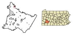 Location of Oklahoma in Westmoreland County, Pennsylvania. | |
 Oklahoma, Pennsylvania Location of Oklahoma in Westmoreland County, Pennsylvania. | |
| Coordinates: 40°34′54″N 79°34′29″W / 40.58167°N 79.57472°WCoordinates: 40°34′54″N 79°34′29″W / 40.58167°N 79.57472°W | |
| Country | United States |
| State | Pennsylvania |
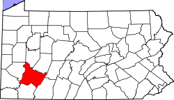
| County | Westmoreland |
| Incorporated | 1931 |
| Government | |
| • Type | Borough Council |
| Area[1] | |
| • Total | 0.64 sq mi (1.66 km2) |
| • Land | 0.61 sq mi (1.57 km2) |
| • Water | 0.03 sq mi (0.09 km2) |
| Elevation | 1,056 ft (322 m) |
| Population (2010) | |
| • Total | 809 |
| • Estimate (2016)[2] | 778 |
| • Density | 1,281.71/sq mi (495.03/km2) |
| Time zone | UTC-5 (Eastern (EST)) |
| • Summer (DST) | UTC-4 (EDT) |
| FIPS code | 42-56496 |
Oklahoma is a borough in Westmoreland County, Pennsylvania, United States. The population was 915 at the 2000 census.
Geography
Oklahoma is located at 40°34′54″N 79°34′29″W / 40.58167°N 79.57472°W (40.581613, -79.574586).[3]
According to the United States Census Bureau, the borough has a total area of 0.8 square miles (2.1 km2), of which, 0.7 square miles (1.8 km2) of it is land and 0.04 square miles (0.10 km2) of it (5.06%) is water.
Surrounding communities
Oklahoma has two land borders, including the townships of Washington to the south and Allegheny to the northwest. Across the Kiskiminetas River to the east, Oklahoma runs adjacent with the Armstrong County municipalities of (from north to south) North Apollo, Apollo (with a connector via 1st Street Bridge), and Kiskiminetas Township.
Demographics
| Historical population | |||
|---|---|---|---|
| Census | Pop. | %± | |
| 1940 | 868 | — | |
| 1950 | 930 | 7.1% | |
| 1960 | 983 | 5.7% | |
| 1970 | 1,084 | 10.3% | |
| 1980 | 1,078 | −0.6% | |
| 1990 | 977 | −9.4% | |
| 2000 | 915 | −6.3% | |
| 2010 | 809 | −11.6% | |
| Est. 2016 | 778 | [2] | −3.8% |
| Sources:[4][5][6] | |||
As of the census[5] of 2000, there were 915 people, 375 households, and 270 families residing in the borough. The population density was 1,233.0 people per square mile (477.4/km²). There were 390 housing units at an average density of 525.5 per square mile (203.5/km²). The racial makeup of the borough was 98.91% White, 0.66% African American, and 0.44% from two or more races. Hispanic or Latino of any race were 0.22% of the population.
There were 375 households out of which 31.5% had children under the age of 18 living with them, 56.0% were married couples living together, 10.9% had a female householder with no husband present, and 28.0% were non-families. 24.5% of all households were made up of individuals and 14.4% had someone living alone who was 65 years of age or older. The average household size was 2.44 and the average family size was 2.89.
In the borough the population was spread out with 24.2% under the age of 18, 5.9% from 18 to 24, 27.0% from 25 to 44, 24.6% from 45 to 64, and 18.4% who were 65 years of age or older. The median age was 41 years. For every 100 females, there were 86.4 males. For every 100 females age 18 and over, there were 87.1 males.
The median income for a household in the borough was $38,667, and the median income for a family was $41,477. Males had a median income of $35,313 versus $23,750 for females. The per capita income for the borough was $17,547. About 4.7% of families and 6.7% of the population were below the poverty line, including 4.6% of those under age 18 and 10.3% of those age 65 or over.
References
- ↑ "2016 U.S. Gazetteer Files". United States Census Bureau. Retrieved Aug 14, 2017.
- 1 2 "Population and Housing Unit Estimates". Retrieved June 9, 2017.
- ↑ "US Gazetteer files: 2010, 2000, and 1990". United States Census Bureau. 2011-02-12. Retrieved 2011-04-23.
- ↑ "Census of Population and Housing". U.S. Census Bureau. Archived from the original on May 12, 2015. Retrieved 11 December 2013.
- 1 2 "American FactFinder". United States Census Bureau. Archived from the original on September 11, 2013. Retrieved 2008-01-31.
- ↑ "Incorporated Places and Minor Civil Divisions Datasets: Subcounty Resident Population Estimates: April 1, 2010 to July 1, 2012". Population Estimates. U.S. Census Bureau. Archived from the original on June 17, 2013. Retrieved 11 December 2013.
| Counties |  Map of the Pittsburgh Tri-State with green counties in the metropolitan area and yellow counties in the combined area. | |
|---|---|---|
| Major cities | ||
| Cities and towns 15k-50k (in 2010) | ||
| Airports | ||
| Topics | ||
| ||