Darragh, Pennsylvania
| Darragh, Pennsylvania | |
|---|---|
| Unincorporated community | |
 Darragh | |
| Coordinates: 40°15′59″N 79°40′43″W / 40.26639°N 79.67861°WCoordinates: 40°15′59″N 79°40′43″W / 40.26639°N 79.67861°W | |
| Country | United States |
| State | Pennsylvania |
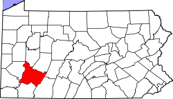
| County | Westmoreland |
| Elevation | 978 ft (298 m) |
| Time zone | UTC-5 (Eastern (EST)) |
| • Summer (DST) | UTC-4 (EDT) |
| ZIP code | 15625 |
| Area code(s) | 724 |
| GNIS feature ID | 1172961[1] |
Darragh is an unincorporated community in Hempfield Township, Westmoreland County, Pennsylvania, United States.[1] The community is located along Pennsylvania Route 136 1 mile (1.6 km) west of Arona. Darragh has a post office with ZIP code 15625, which opened on July 21, 1892.[2][3]
References
- 1 2 "Darragh". Geographic Names Information System. United States Geological Survey.
- ↑ United States Postal Service. "USPS - Look Up a ZIP Code". Retrieved December 20, 2015.
- ↑ "Postmaster Finder - Post Offices by ZIP Code". United States Postal Service. Retrieved December 20, 2015.
This article is issued from
Wikipedia.
The text is licensed under Creative Commons - Attribution - Sharealike.
Additional terms may apply for the media files.