East Huntingdon Township, Westmoreland County, Pennsylvania
| East Huntingdon Township, Pennsylvania | |
|---|---|
| Township | |
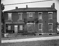 The former Christian S. Overholt Store in West Overton | |
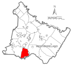 Map of Westmoreland County, Pennsylvania Highlighting East Huntingdon Township | |
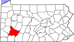 Map of Pennsylvania highlighting Westmoreland County | |
| Country | United States |
| State | Pennsylvania |
| County | Westmoreland |
| Settled | 1790 |
| Incorporated | 1798 |
| Area[1] | |
| • Total | 32.96 sq mi (85.37 km2) |
| • Land | 32.95 sq mi (85.35 km2) |
| • Water | 0.01 sq mi (0.02 km2) |
| Population (2010) | |
| • Total | 7,963 |
| • Estimate (2016)[2] | 7,716 |
| • Density | 234.14/sq mi (90.40/km2) |
| Time zone | UTC-5 (Eastern (EST)) |
| • Summer (DST) | UTC-4 (EDT) |
| FIPS code | 42-129-21304 |
East Huntingdon Township is a township in Westmoreland County, Pennsylvania, United States. The population was 7,781 at the 2000 census. From 1978 to 1988, the township had been home to the Volkswagen Westmoreland Assembly Plant, which later became a Sony plant and as of 2010 sits idle.[3]
History
The West Overton Historic District was listed on the National Register of Historic Places in 1985.[4]
Geography
According to the United States Census Bureau, the township has a total area of 32.8 square miles (85 km2), of which, 32.8 square miles (85 km2) of it is land and 0.03% is water.
Demographics
| Historical population | |||
|---|---|---|---|
| Census | Pop. | %± | |
| 2010 | 7,963 | — | |
| Est. 2016 | 7,716 | [2] | −3.1% |
| U.S. Decennial Census[5] | |||
As of the census[6] of 2000, there were 7,781 people, 3,142 households, and 2,271 families residing in the township. The population density was 237.3 people per square mile (91.6/km²). There were 3,289 housing units at an average density of 100.3/sq mi (38.7/km²). The racial makeup of the township was 98.68% White, 0.48% African American, 0.09% Native American, 0.22% Asian, 0.03% Pacific Islander, 0.13% from other races, and 0.39% from two or more races. Hispanic or Latino of any race were 0.30% of the population.
There were 3,142 households out of which 30.0% had children under the age of 18 living with them, 57.7% were married couples living together, 10.5% had a female householder with no husband present, and 27.7% were non-families. 24.3% of all households were made up of individuals and 11.4% had someone living alone who was 65 years of age or older. The average household size was 2.46 and the average family size was 2.92.
In the township the population was spread out with 22.5% under the age of 18, 6.9% from 18 to 24, 29.3% from 25 to 44, 24.3% from 45 to 64, and 17.0% who were 65 years of age or older. The median age was 40 years. For every 100 females, there were 92.4 males. For every 100 females age 18 and over, there were 90.8 males.
The median income for a household in the township was $32,460, and the median income for a family was $39,927. Males had a median income of $29,835 versus $22,787 for females. The per capita income for the township was $15,598. About 9.0% of families and 10.6% of the population were below the poverty line, including 15.1% of those under age 18 and 8.7% of those age 65 or over.
References
- ↑ "2016 U.S. Gazetteer Files". United States Census Bureau. Retrieved Aug 14, 2017.
- 1 2 "Population and Housing Unit Estimates". Retrieved June 9, 2017.
- ↑ "Former Sony Corp. plant near New Stanton auditions for new tenant". Pittsburgh Tribune-Review, Joe Napsha, June 23, 2010.
- ↑ National Park Service (2010-07-09). "National Register Information System". National Register of Historic Places. National Park Service.
- ↑ "Census of Population and Housing". Census.gov. Retrieved June 4, 2016.
- ↑ "American FactFinder". United States Census Bureau. Archived from the original on 2013-09-11. Retrieved 2008-01-31.
| Counties |  Map of the Pittsburgh Tri-State with green counties in the metropolitan area and yellow counties in the combined area. | |
|---|---|---|
| Major cities | ||
| Cities and towns 15k-50k (in 2010) | ||
| Airports | ||
| Topics | ||
| ||
Coordinates: 40°07′00″N 79°34′59″W / 40.11667°N 79.58306°W