Laughlintown, Pennsylvania
| Laughlintown, Pennsylvania | |
|---|---|
| Unincorporated community | |
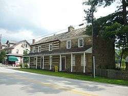 The Compass Inn in Laughlintown | |
 Laughlintown | |
| Coordinates: 40°12′43″N 79°11′52″W / 40.21194°N 79.19778°WCoordinates: 40°12′43″N 79°11′52″W / 40.21194°N 79.19778°W | |
| Country | United States |
| State | Pennsylvania |
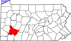
| County | Westmoreland |
| Elevation | 1,289 ft (393 m) |
| Time zone | UTC-5 (Eastern (EST)) |
| • Summer (DST) | UTC-4 (EDT) |
| ZIP code | 15655 |
| Area code(s) | 724 |
| GNIS feature ID | 1178918[1] |
Laughlintown is an unincorporated community in Ligonier Township, Westmoreland County, Pennsylvania, United States.[1] Laughlintown is located on U.S. Route 30 3 miles (4.8 km) southeast of Ligonier. Laughlintown has a post office with ZIP code 15655, which opened on May 16, 1825.[2][3]
The Compass Inn, which is listed on the National Register of Historic Places, is located in Laughlintown. Also the Rolling Rock Club and The Washington Furnace Inn is located in Laughlintown.[4]
Notes
- 1 2 "Laughlintown". Geographic Names Information System. United States Geological Survey.
- ↑ United States Postal Service (2012). "USPS - Look Up a ZIP Code". Retrieved 2012-02-15.
- ↑ "Postmaster Finder - Post Offices by ZIP Code". United States Postal Service. Retrieved May 22, 2013.
- ↑ National Park Service (2010-07-09). "National Register Information System". National Register of Historic Places. National Park Service.
This article is issued from
Wikipedia.
The text is licensed under Creative Commons - Attribution - Sharealike.
Additional terms may apply for the media files.