Cokeville, Pennsylvania
| Cokeville | |
|---|---|
| Unincorporated community | |
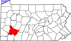
 Cokeville Location within the state of Pennsylvania | |
| Coordinates: 40°25′6″N 79°15′20″W / 40.41833°N 79.25556°WCoordinates: 40°25′6″N 79°15′20″W / 40.41833°N 79.25556°W | |
| Country | United States |
| State | Pennsylvania |
| County | Westmoreland |
| Elevation | 938 ft (286 m) |
| Time zone | UTC-5 (Eastern (EST)) |
| • Summer (DST) | UTC-4 (EDT) |
| GNIS feature ID | 1170039[1] |
Cokeville was a town in Westmoreland County, Pennsylvania, United States. Following the St. Patrick's Day flood of 1936, the Army Corp Of Engineers began planning a dam project on the Conemaugh River to harness the flood waters. There were 122 structures in Cokeville on a 1951 map. In 1952, as the town was being evacuated for the flood control project, most of these structures were razed, but some were moved up the hill to Cokeville Heights near Rt. 217.
The town traces its roots back to 1858 when it was known as Broad Fording. Cokeville was served by the Pennsylvania Mainline Canal until the Pennsylvania Railroad located its tracks along the canals towpath around 1864. The name was changed in the early 1870s to Coketown, Coketon, and finally Cokeville after The Isabella Furnace Coke Company erected a 200 oven coke plant on the hillside above the town. The town was incorporated in 1887. The coke produced here was shipped to the Isabella Blast Furnace in Etna, PA on the Allegheny River. The H.C. Frick Coke Company took over the operation around 1901 and the ovens went out permanently in 1903.
The only remnants of the town today are the bridge abutments of the road bridge from Blairsville as well as the railroad bridge abutments a little further up the river. There are still concrete roads on the two sides of the town.
References
| Counties |  Map of the Pittsburgh Tri-State with green counties in the metropolitan area and yellow counties in the combined area. | |
|---|---|---|
| Major cities | ||
| Cities and towns 15k-50k (in 2010) | ||
| Airports | ||
| Topics | ||
| ||