| [3] |
Name on the Register[4] |
Image |
Date listed[5] |
Location |
City or town |
Description |
|---|
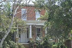
| 1 |
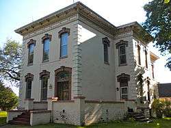
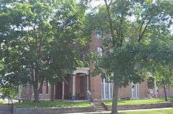
Albright House |
|
July 24, 1978
(#78001233) |
716-718 Ave. F
40°37′54″N 91°18′38″W / 40.631667°N 91.310556°W / 40.631667; -91.310556 (Albright House) |
Fort Madison |
|
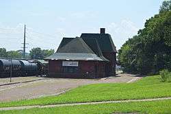
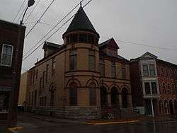
| 2 |
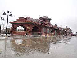
Atchison, Topeka and Santa Fe Passenger and Freight Complex Historic District |
|
March 5, 1992
(#92000100) |
902 Ave. H
40°37′48″N 91°18′49″W / 40.63°N 91.313611°W / 40.63; -91.313611 (Atchison, Topeka and Santa Fe Passenger and Freight Complex Historic District) |
Fort Madison |
A former passenger train station and a former freight station built in 1909 by the Atchison, Topeka and Santa Fe Railway. |
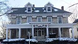
| 3 |
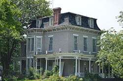
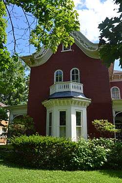
Chief Justice Joseph M. Beck House |
|
July 21, 1988
(#88001116) |
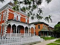
630 Ave. E
40°37′58″N 91°18′34″W / 40.632778°N 91.309444°W / 40.632778; -91.309444 (Chief Justice Joseph M. Beck House) |
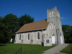
Fort Madison |
|
| 4 |
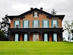
Gen. William Worth Belknap House |
|
October 10, 1975
(#75000694) |
511 N. 3rd St.
40°23′51″N 91°22′33″W / 40.397500°N 91.375833°W / 40.397500; -91.375833 (Gen. William Worth Belknap House) |
Keokuk |
Greek Revival home built in 1854 by William Worth Belknap who became a Civil War general and Secretary of War under President Ulysses S. Grant. |
| 5 |
Bridgeport Bridge |
|
May 15, 1998
(#98000533) |
Old Quarry Rd.
40°47′25″N 91°21′50″W / 40.790278°N 91.363889°W / 40.790278; -91.363889 (Bridgeport Bridge) |
Denmark |
A Pennsylvania through truss bridge built by the Clinton Bridge and Iron Works and completed in 1904. Extends into Des Moines County. |
| 6 |
Cattermole Memorial Library |
|
April 5, 1984
(#84001267) |
614 7th St.
40°37′53″N 91°18′34″W / 40.631389°N 91.309444°W / 40.631389; -91.309444 (Cattermole Memorial Library) |
Fort Madison |
|
| 7 |
Gen. Samuel R. Curtis House |
|
April 23, 1998
(#98000384) |
206 High St.
40°23′43″N 91°22′42″W / 40.395278°N 91.378333°W / 40.395278; -91.378333 (Gen. Samuel R. Curtis House) |
Keokuk |
Greek Revival residence of Civil War general Samuel R. Curtis. |
| 8 |
Denmark Congregational Church |
|
December 2, 1977
(#77000534) |
Academy Ave. and 4th St.
40°44′31″N 91°20′00″W / 40.741944°N 91.333333°W / 40.741944; -91.333333 (Denmark Congregational Church) |
Denmark |
Abolitionist Asa Turner, Jr. was pastor of the church in the mid-19th century. |
| 9 |
Faeth Farmstead and Orchard District |
|
September 16, 2005
(#05001020) |
2469 Iowa Highway 2
40°38′11″N 91°26′11″W / 40.636389°N 91.436389°W / 40.636389; -91.436389 (Faeth Farmstead and Orchard District) |
Fort Madison |
On the Most Endangered list of the Iowa Historic Preservation Alliance[6] |
| 10 |
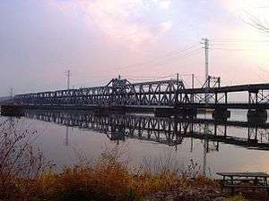
Fort Madison Bridge |
|
August 27, 1999
(#99001035) |
Iowa Highway 9 over the Mississippi River
40°37′16″N 91°17′15″W / 40.621111°N 91.2875°W / 40.621111; -91.2875 (Fort Madison Bridge) |
Fort Madison |
A swinging truss toll bridge over the Mississippi River that connects Fort Madison with Niota in Hancock County, Illinois |
| 11 |
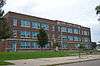
Fort Madison High School |
|
January 21, 2015
(#14001169) |
1812 Avenue F
40°37′54″N 91°19′50″W / 40.631667°N 91.330556°W / 40.631667; -91.330556 (Fort Madison High School) |
Fort Madison |
|
| 12 |
Fort Madison Downtown Commercial Historic District |
|
August 31, 2007
(#07000852) |
Centered on Avenue G, from near 6th St. to the middle of the 900 block, including Avenue H from 7th to 9th
40°37′51″N 91°18′40″W / 40.630942°N 91.311208°W / 40.630942; -91.311208 (Fort Madison Downtown Commercial Historic District) |
Fort Madison |
Federal and Late Victorian buildings from the late 19th century. |
| 13 |
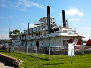
GEO. M. VERITY |
|
December 20, 1989
(#89002459) |
Keokuk River Museum, Victory Park
40°23′35″N 91°22′21″W / 40.393056°N 91.3725°W / 40.393056; -91.3725 (GEO. M. VERITY) |
Keokuk |
Towboat built by the Dubuque Boat & Boiler Works in 1927. |
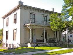
| 14 |
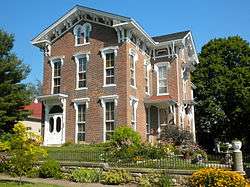
E. H. Harrison House |
|
January 12, 1984
(#84001270) |
220 N. 4th St.
40°23′49″N 91°22′47″W / 40.396806°N 91.379722°W / 40.396806; -91.379722 (E. H. Harrison House) |
Keokuk |
A combination Federal and Second Empire style house designed by Frederick H. Moore from 1857. |
| 15 |
Christian and Katharina Herschler House, Barn, and Outbuildings Historic District |
|
February 16, 1996
(#96000064) |
Junction of 6th and Green Sts.
40°39′53″N 91°30′49″W / 40.664722°N 91.513611°W / 40.664722; -91.513611 (Christian and Katharina Herschler House, Barn, and Outbuildings Historic District) |
Franklin |
|
| 16 |
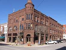
Hotel Iowa |
|
February 5, 1987
(#87000022) |
401 Main St.
40°23′43″N 91°22′55″W / 40.395278°N 91.381944°W / 40.395278; -91.381944 (Hotel Iowa) |
Keokuk |
An eight-story Chicago Commercial style building from 1913. |
| 17 |
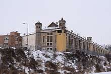
Iowa State Penitentiary Cellhouses Historic District |
|
December 18, 1992
(#92001663) |
Junction of Avenue G and U.S. Route 61
40°38′02″N 91°17′45″W / 40.633889°N 91.295833°W / 40.633889; -91.295833 (Iowa State Penitentiary Cellhouses Historic District) |
Fort Madison |
State penitentiary that was founded in the Territory of Iowa in 1839 and patterned after the penitentiary in Auburn, New York. |
| 18 |
John N. and Mary L. (Rankin) Irwin House |
|
October 14, 1999
(#99001206) |
633 Grand Ave.
40°24′05″N 91°22′34″W / 40.401389°N 91.376111°W / 40.401389; -91.376111 (John N. and Mary L. (Rankin) Irwin House) |
Keokuk |
Two-story brick home of John N. Irwin who served as the territorial governor of the Idaho Territory, the Arizona Territory and as the US minister to Portugal. |
| 19 |
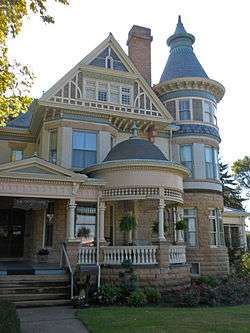
C. R. Joy House |
|
January 16, 1997
(#96001587) |
816 Grand Ave.
40°24′16″N 91°22′34″W / 40.404444°N 91.376111°W / 40.404444; -91.376111 (C. R. Joy House) |
Keokuk |
Queen Anne style house designed by architect George Franklin Barber. |
| 20 |
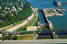
Keokuk Lock and Dam |
|
October 19, 1978
(#78001234) |
At the Mississippi River
40°23′51″N 91°22′01″W / 40.3975°N 91.366944°W / 40.3975; -91.366944 (Keokuk Lock and Dam) |
Keokuk |
A 4,620 feet (1,408.2 m) long dam across the Mississippi River. It includes locks that are 1,200 feet (365.8 m) long and 110 feet (33.5 m) wide. |
| 21 |
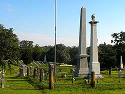
Keokuk National Cemetery |
|
June 4, 1997
(#97000528) |
1701 J St.
40°23′58″N 91°24′18″W / 40.399444°N 91.405°W / 40.399444; -91.405 (Keokuk National Cemetery) |
Keokuk |
American Civil War era cemetery that was established to bury the Union soldiers who died in the five army hospitals that were located in Keokuk. |
| 22 |
Keokuk Union Depot |
|
March 27, 2013
(#13000109) |
200 Exchange St.
40°23′26″N 91°22′54″W / 40.390556°N 91.381667°W / 40.390556; -91.381667 (Keokuk Union Depot) |
Keokuk |
|
| 23 |
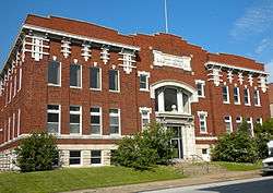
Keokuk Young Women's Christian Association Building |
|
October 12, 2004
(#04001140) |
425 Blondeau St.
40°23′47″N 91°22′54″W / 40.396389°N 91.381667°W / 40.396389; -91.381667 (Keokuk Young Women's Christian Association Building) |
Keokuk |
A 1913 building that is representative of transitional architecture in the early 20th century. |
| 24 |
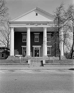
Lee County Courthouse |
|
September 30, 1976
(#76000777) |
701 Ave. F
40°37′55″N 91°18′36″W / 40.631944°N 91.31°W / 40.631944; -91.31 (Lee County Courthouse) |
Fort Madison |
Greek Revival style building from 1842. It is the courthouse for northern Lee County. |
| 25 |
Lock and Dam No. 19 Historic District |
|
March 10, 2004
(#04000179) |
525 N. Water St.
40°23′45″N 91°22′32″W / 40.395847°N 91.375681°W / 40.395847; -91.375681 (Lock and Dam No. 19 Historic District) |
Keokuk |
Historic district that includes 7 buildings, 12 structures, 1 object. |
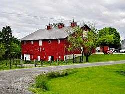
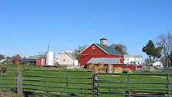
| 26 |
Daniel McConn Barn |
|
May 26, 2000
(#00000531) |
2095 US Business 61
40°39′10″N 91°16′34″W / 40.652778°N 91.276111°W / 40.652778; -91.276111 (Daniel McConn Barn) |
Fort Madison |
|
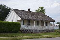
| 27 |
John McGreer Barn and Crib |
|
August 8, 2001
(#01000859) |
2056 150th Ave.
40°39′34″N 91°37′22″W / 40.659553°N 91.622661°W / 40.659553; -91.622661 (John McGreer Barn and Crib) |
Donnellson |
|
| 28 |
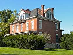
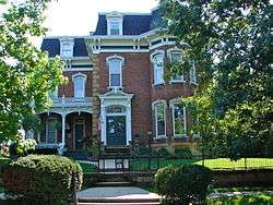
Justice Samuel Freeman Miller House |
|
October 10, 1972
(#72000477) |
318 N. 5th St.
40°23′53″N 91°22′46″W / 40.398056°N 91.379444°W / 40.398056; -91.379444 (Justice Samuel Freeman Miller House) |
Keokuk |
An Italianate house from 1859 that was home to Samuel Freeman Miller who served for 28 years on the United States Supreme Court. |
| 29 |
Moyce-Steffens House |
|
May 2, 1997
(#97000394) |
1615 Avenue H
40°37′49″N 91°19′38″W / 40.630278°N 91.327222°W / 40.630278; -91.327222 (Moyce-Steffens House) |
Fort Madison |
|
| 30 |
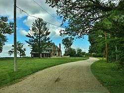
Old Fort Madison Site |
|
May 7, 1973
(#73000734) |
Address Restricted
|
Fort Madison |
The first permanent U.S. military fortification on the Upper Mississippi River. On the Most Endangered list of the Iowa Historic Preservation Alliance.[6] Boundary increases approved April 18, 2018. |
| 31 |
Park-to-Park Residential Historic District |
|
December 22, 2014
(#14001069) |
400-1100 blks. of Ave. F & 400-1100 blks. of Ave. E
40°37′58″N 91°18′35″W / 40.6327°N 91.3097°W / 40.6327; -91.3097 (Park-to-Park Residential Historic District) |
Fort Madison |
|
| 32 |
Primrose Mill |
|
March 17, 1983
(#83000383) |
Off Iowa Highway 2
40°40′31″N 91°38′16″W / 40.675278°N 91.637778°W / 40.675278; -91.637778 (Primrose Mill) |
Primrose |
|
| 33 |
Saint Barnabas Episcopal Church |
|
April 11, 1986
(#86000721) |
Chestnut St.
40°31′54″N 91°25′06″W / 40.531667°N 91.418333°W / 40.531667; -91.418333 (Saint Barnabas Episcopal Church) |
Montrose |
Gothic Revival style church from 1869. |
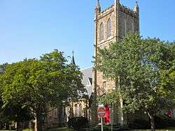
| 34 |
St. John's Episcopal Church and Parish Hall |
|
July 11, 1989
(#89000806) |
4th and Concert
40°23′48″N 91°22′58″W / 40.396667°N 91.382778°W / 40.396667; -91.382778 (St. John's Episcopal Church and Parish Hall) |
Keokuk |
Gothic Revival church designed by Daniel Appleton and H.M. Stephenson. It was built from 1884 to 1888. |
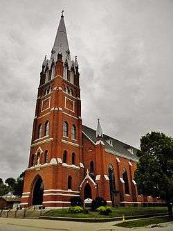
| 35 |
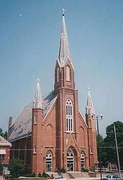
St. Mary of the Assumption Church |
|
February 8, 1980
(#80001455) |
1031 Ave. E
40°38′00″N 91°19′00″W / 40.633333°N 91.316667°W / 40.633333; -91.316667 (St. Mary of the Assumption Church) |
Fort Madison |
Gothic Revival style church designed by Walch & Schmidt and completed in 1871. It is now a part of Holy Family parish. |
| 36 |
St. Peter Church |
|
July 14, 1983
(#83000384) |
301 S. 9th St.
40°23′50″N 91°23′25″W / 40.397222°N 91.390278°W / 40.397222; -91.390278 (St. Peter Church) |
Keokuk |
Gothic Revival church built between 1879 and 1885. It is now known as the Church of All Saints. |
| 37 |
Hugh W. and Sarah Sample House |
|
November 22, 1995
(#95001318) |
205 N. 2nd St.
40°23′40″N 91°22′45″W / 40.394444°N 91.379167°W / 40.394444; -91.379167 (Hugh W. and Sarah Sample House) |
Keokuk |
Italianate style house from 1859. |
| 38 |
George E. Schlapp House |
|
February 4, 1982
(#82002627) |
639 Ave. C
40°38′09″N 91°18′32″W / 40.635833°N 91.308889°W / 40.635833; -91.308889 (George E. Schlapp House) |
Fort Madison |
|
| 39 |
Sharon Cemetery Historic District |
|
January 11, 1991
(#90002133) |
County Road J40 about 3 miles (4.8 km) east of the Van Buren county line
40°43′31″N 91°39′41″W / 40.725278°N 91.661389°W / 40.725278; -91.661389 (Sharon Cemetery Historic District) |
Farmington |
|
| 40 |
Craig and Virginia Sheaffer House |
|
April 22, 1993
(#93000329) |
10 High Point
40°38′04″N 91°17′10″W / 40.634444°N 91.286111°W / 40.634444; -91.286111 (Craig and Virginia Sheaffer House) |
Fort Madison |
|
| 41 |
Walter A. Sheaffer House |
|
September 19, 2006
(#06000858) |
11 High Point
40°38′02″N 91°17′14″W / 40.633889°N 91.287222°W / 40.633889; -91.287222 (Walter A. Sheaffer House) |
Fort Madison |
|
| 42 |
The Park Place-Grand Avenue Residential District |
|
September 12, 2002
(#02001020) |
4th at Park Place and Orleans St. and north up Grand Ave. to Rand Park
40°24′18″N 91°22′36″W / 40.405°N 91.376667°W / 40.405; -91.376667 (The Park Place-Grand Avenue Residential District) |
Keokuk |
Residential area of Late Victorian homes that were mostly built in the early 20th century. |
| 43 |
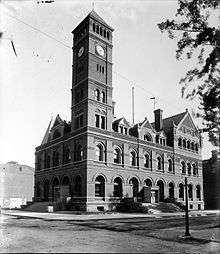
U.S. Post Office and Courthouse |
|
January 24, 1974
(#74000796) |
25 N. 7th St.
40°23′51″N 91°23′02″W / 40.3975°N 91.383889°W / 40.3975; -91.383889 (U.S. Post Office and Courthouse) |
Keokuk |
Late Victorian building from 1887. It was originally built as a Federal courthouse, but now serves as the South Lee County Courthouse as well as a post office. |
| 44 |
Alois and Annie Weber House |
|
April 16, 2002
(#02000375) |
802 Orleans Ave.
40°24′09″N 91°22′44″W / 40.402500°N 91.378889°W / 40.402500; -91.378889 (Alois and Annie Weber House) |
Keokuk |
Second Empire style home from 1873. |
| 45 |
Frank J. Weess House |
|
May 22, 1978
(#78001235) |
224-226 Morgan St.
40°23′47″N 91°22′39″W / 40.396389°N 91.3775°W / 40.396389; -91.3775 (Frank J. Weess House) |
Keokuk |
Second Empire style home that was built from 1880 to 1881. |
.jpg)
.jpg)