Argyle, Iowa
| Argyle, Iowa | |
|---|---|
| Unincorporated community | |
 | |
 Argyle, Iowa Location within the state of Iowa | |
| Coordinates: 40°31′54″N 91°33′59″W / 40.53167°N 91.56639°WCoordinates: 40°31′54″N 91°33′59″W / 40.53167°N 91.56639°W | |
| Country | United States |
| State | Iowa |
| County | Lee |
| Elevation | 679 ft (207 m) |
| Time zone | UTC-6 (Central (CST)) |
| • Summer (DST) | UTC-5 (CDT) |
| ZIP codes | 52619 |
| Area code(s) | 319 |
| GNIS feature ID | 454227[1] |
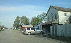
Argyle is an unincorporated community in southwestern Lee County, Iowa, United States. It lies along the concurrent Iowa Highways 27 and 394 southwest of the city of Fort Madison, the county seat of Lee County.[2] Its elevation is 679 feet (207 m).[1] Although Argyle is unincorporated, it has a post office, with the ZIP code of 52619,[3] which opened on 1888-03-15.[4] The community is part of the Fort Madison–Keokuk, IA-MO Micropolitan Statistical Area.
The Central Lee Community School District serves the community.[5]
References
- 1 2 "Argyle, Iowa". Geographic Names Information System. United States Geological Survey.
- ↑ Rand McNally. The Road Atlas '08. Chicago: Rand McNally, 2008, p. 39.
- ↑ Zip Code Lookup Archived June 15, 2011, at the Wayback Machine.
- ↑ U.S. Geological Survey Geographic Names Information System: Argyle Post Office
- ↑ "About Central Lee". Central Lee Community School District. Retrieved 2018-09-16.
Municipalities and communities of Lee County, Iowa, United States | ||
|---|---|---|
| Cities | 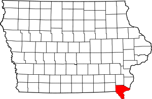 | |
| Townships | ||
| CDP | ||
| Other unincorporated communities | ||
This article is issued from
Wikipedia.
The text is licensed under Creative Commons - Attribution - Sharealike.
Additional terms may apply for the media files.