| [3] |
Name on the Register[4] |
Image |
Date listed[5] |
Location |
City or town |
Description |
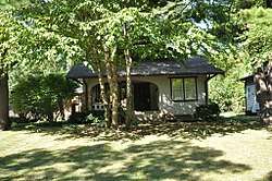
|---|
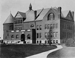
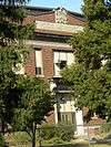
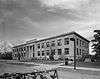
| 1 |
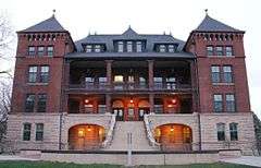
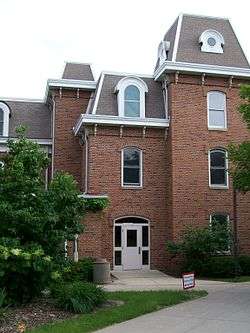
Agriculture Hall |
|
June 27, 1985
(#85001374) |
Iowa State University campus -- now known as "Catt Hall"
42°01′40″N 93°38′44″W / 42.027778°N 93.645556°W / 42.027778; -93.645556 (Agriculture Hall) |
Ames |
|
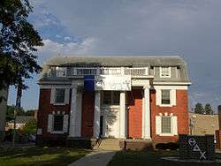
| 2 |
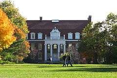
Alumni Hall |
|
November 16, 1978
(#78001260) |
Iowa State University campus -- now known as the "Enrollment Services Center"
42°01′30″N 93°38′56″W / 42.025°N 93.648889°W / 42.025; -93.648889 (Alumni Hall) |
Ames |
|
| 3 |
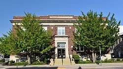
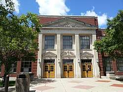
Ames High School |
|
October 24, 2002
(#02001229) |
515 Clark Ave.
42°01′35″N 93°37′02″W / 42.026389°N 93.617361°W / 42.026389; -93.617361 (Ames High School) |
Ames |
Now city hall |
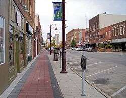
| 4 |
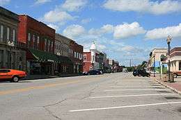
Ames Main Street Historic District |
|
May 10, 2018
(#100002399) |
Roughly 100-400 blks. of Main & 5th Sts. with cross streets of Burnett, Kellogg, Douglas & Duff Sts.
42°01′32″N 93°36′49″W / 42.0255°N 93.6137°W / 42.0255; -93.6137 (Ames Main Street Historic District) |
Ames |
|
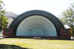
| 5 |
Bandshell Park Historic District |
|
October 7, 1999
(#99001238) |
Bounded by Duff Ave., E. 5th St., E. 6th St., and Carroll Ave.
42°01′35″N 93°36′33″W / 42.026389°N 93.609167°W / 42.026389; -93.609167 (Bandshell Park Historic District) |
Ames |
|
| 6 |
Briggs Terrace |
|
July 20, 1998
(#98000868) |
1204 H Ave.
42°01′06″N 93°26′18″W / 42.018333°N 93.438333°W / 42.018333; -93.438333 (Briggs Terrace) |
Nevada |
|
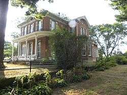
| 7 |
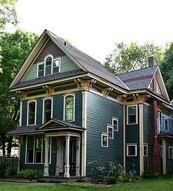
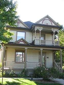
Prof. J.L. Budd, Sarah M., and Etta Budd House |
|
August 8, 2001
(#01000860) |
804 Kellogg Ave.
42°01′16″N 93°36′49″W / 42.021111°N 93.613611°W / 42.021111; -93.613611 (Prof. J.L. Budd, Sarah M., and Etta Budd House) |
Ames |
|
| 8 |
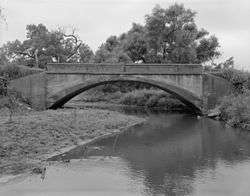
Calamus Creek Bridge |
|
May 15, 1998
(#98000486) |
325th St. over Calamus Creek
41°53′04″N 93°22′54″W / 41.884444°N 93.381667°W / 41.884444; -93.381667 (Calamus Creek Bridge) |
Maxwell |
|
| 9 |
Christian Petersen Courtyard Sculptures, and Dairy Industry Building |
|
April 7, 1987
(#87000020) |
Wallace Rd., between Beach and Union Dr. on the Iowa State University campus - now known as the 'Food Sciences' building
42°01′37″N 93°38′34″W / 42.026944°N 93.642778°W / 42.026944; -93.642778 (Christian Petersen Courtyard Sculptures, and Dairy Industry Building) |
Ames |
|
| 10 |
Colonials Club House |
|
February 8, 2012
(#12000003) |
217 Ash Ave.
42°01′16″N 93°38′42″W / 42.021036°N 93.644972°W / 42.021036; -93.644972 (Colonials Club House) |
Ames |
|
| 11 |
Delta Upsilon Chapter House |
|
November 10, 2010
(#10000919) |
117 Ash Ave.
42°01′19″N 93°38′41″W / 42.021944°N 93.644722°W / 42.021944; -93.644722 (Delta Upsilon Chapter House) |
Ames |
|
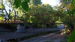
| 12 |
East Indian Creek Bridge |
|
May 15, 1998
(#98000485) |
260th St. over East Indian Creek
41°58′31″N 93°23′13″W / 41.975278°N 93.386944°W / 41.975278; -93.386944 (East Indian Creek Bridge) |
Nevada |
|
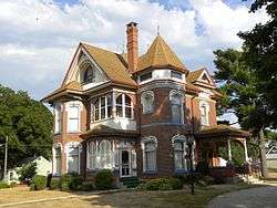
| 13 |
Edwards-Swayze House |
|
November 14, 1978
(#78001262) |
1110 9th St.
42°01′13″N 93°26′53″W / 42.020278°N 93.448056°W / 42.020278; -93.448056 (Edwards-Swayze House) |
Nevada |
|
| 14 |
Engineering Hall |
|
January 10, 1983
(#83000402) |
Union Dr. on the Iowa State University campus
42°01′32″N 93°39′02″W / 42.0256°N 93.6506°W / 42.0256; -93.6506 (Engineering Hall) |
Ames |
Now called the Lab of Mechanics |
| 15 |
Grand Auditorium and Hotel Block |
|
January 25, 1980
(#80001460) |
Broad St.
42°11′13″N 93°35′48″W / 42.186944°N 93.596667°W / 42.186944; -93.596667 (Grand Auditorium and Hotel Block) |
Story City |
|
| 16 |
Henry T. and Emilie (Wiese) Henryson House |
|
April 20, 2005
(#05000317) |
619 Grad Ave.
42°11′16″N 93°36′12″W / 42.187778°N 93.603333°W / 42.187778; -93.603333 (Henry T. and Emilie (Wiese) Henryson House) |
Story City |
|
| 17 |
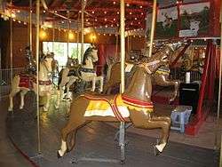
Herschel-Spillman Two-Row Portable Menagerie Carousel |
|
June 6, 1986
(#86001244) |
North Park, Story St., and Grove Ave.
42°11′17″N 93°35′16″W / 42.188056°N 93.587778°W / 42.188056; -93.587778 (Herschel-Spillman Two-Row Portable Menagerie Carousel) |
Story City |
|
| 18 |
Iowa Beta Chapter of Sigma Phi Epsilon |
|
February 5, 2014
(#13001140) |
228 Gray Ave.
42°01′14″N 93°38′26″W / 42.020520°N 93.640434°W / 42.020520; -93.640434 (Iowa Beta Chapter of Sigma Phi Epsilon) |
Ames |
|
| 19 |
Keigley Branch Bridge |
|
May 15, 1998
(#98000483) |
550th St. over Keigley Branch
42°08′13″N 93°36′03″W / 42.136944°N 93.600833°W / 42.136944; -93.600833 (Keigley Branch Bridge) |
Gilbert |
|
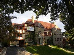
| 20 |
Knapp-Wilson House |
|
October 15, 1966
(#66000339) |
Iowa State University campus
42°01′48″N 93°38′32″W / 42.03°N 93.642222°W / 42.03; -93.642222 (Knapp-Wilson House) |
Ames |
|
| 21 |
Lincoln Township Mausoleum |
|
September 27, 2007
(#07001004) |
County Road E18 at the northern end of Pearl St.
42°09′53″N 93°17′44″W / 42.164722°N 93.295556°W / 42.164722; -93.295556 (Lincoln Township Mausoleum) |
Lincoln Township |
|
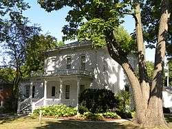
| 22 |
Gilmour B. and Edith Craig MacDonald House |
|
May 6, 1992
(#91001860) |
517 Ash St.
42°00′59″N 93°38′40″W / 42.016389°N 93.644444°W / 42.016389; -93.644444 (Gilmour B. and Edith Craig MacDonald House) |
Ames |
|
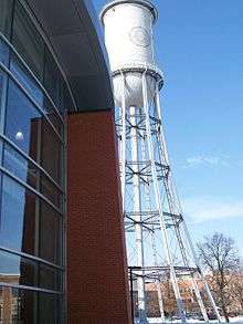
| 23 |
Marston Water Tower |
|
May 27, 1982
(#82002644) |
Iowa State University campus
42°01′37″N 93°39′03″W / 42.026944°N 93.650833°W / 42.026944; -93.650833 (Marston Water Tower) |
Ames |
|
| 24 |
Masonic Temple |
|
September 12, 2016
(#16000608) |
413, 417, 427, 429 Douglas Ave.
42°01′32″N 93°36′44″W / 42.025685°N 93.612112°W / 42.025685; -93.612112 (Masonic Temple) |
Ames |
|
| 25 |
Morrill Hall |
|
June 28, 1996
(#96000700) |
Morrill Rd., facing east toward the central campus of Iowa State University
42°01′38″N 93°38′52″W / 42.027222°N 93.647778°W / 42.027222; -93.647778 (Morrill Hall) |
Ames |
|
| 26 |
Mulcahy Barn |
|
January 28, 2004
(#03001492) |
25623-710th Ave.
41°59′03″N 93°17′27″W / 41.984167°N 93.290833°W / 41.984167; -93.290833 (Mulcahy Barn) |
Colo |
|
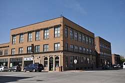
| 27 |
Municipal Building |
|
May 2, 1997
(#97000391) |
420 Kellogg Ave.
42°01′35″N 93°36′47″W / 42.026389°N 93.613056°W / 42.026389; -93.613056 (Municipal Building) |
Ames |
|
| 28 |
Nevada Downtown Historic District |
|
May 9, 2003
(#03000356) |
Approximately 6th St. from I Ave. to M Ave.
42°01′18″N 93°27′08″W / 42.021681°N 93.452306°W / 42.021681; -93.452306 (Nevada Downtown Historic District) |
Nevada |
|
| 29 |
Octagon Round Barn, Indian Creek Township |
|
June 30, 1986
(#86001439) |
Off County Road S14
41°57′00″N 93°27′06″W / 41.95°N 93.451667°W / 41.95; -93.451667 (Octagon Round Barn, Indian Creek Township) |
Indian Creek Township |
|
| 30 |
Old Town Historic District |
|
January 2, 2004
(#03001349) |
Between Duff and Clark Aves., and 7th and 9th Sts.
42°01′46″N 93°37′18″W / 42.029444°N 93.621667°W / 42.029444; -93.621667 (Old Town Historic District) |
Ames |
|
| 31 |
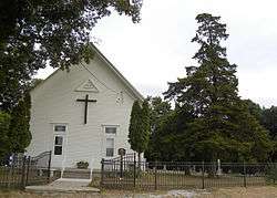
Pleasant Grove Community Church and Cemetery |
|
May 28, 2010
(#10000295) |
56971 170th St.
42°06′23″N 93°33′41″W / 42.106386°N 93.5614°W / 42.106386; -93.5614 (Pleasant Grove Community Church and Cemetery) |
Ames |
|
| 32 |
Roosevelt School |
|
March 2, 2010
(#10000055) |
921 9th St.
42°01′49″N 93°37′24″W / 42.030217°N 93.623206°W / 42.030217; -93.623206 (Roosevelt School) |
Ames |
|
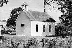
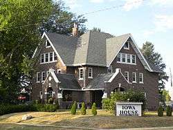
| 33 |
Sheldahl First Norwegian Evangelical Lutheran Church |
|
May 11, 1984
(#84001599) |
3rd and Willow Sts.
41°51′58″N 93°41′42″W / 41.866111°N 93.695°W / 41.866111; -93.695 (Sheldahl First Norwegian Evangelical Lutheran Church) |
Sheldahl |
|
| 34 |
Sigma Sigma-Delta Chi Fraternity House |
|
July 10, 2008
(#08000684) |
405 Hayward Ave.
42°01′09″N 93°39′06″W / 42.01905°N 93.65176°W / 42.01905; -93.65176 (Sigma Sigma-Delta Chi Fraternity House) |
Ames |
|
| 35 |
Skunk River Bridge |
|
May 15, 1998
(#98000484) |
255th St. over the Skunk River
41°59′12″N 93°35′13″W / 41.986667°N 93.586944°W / 41.986667; -93.586944 (Skunk River Bridge) |
Ames |
|
| 36 |
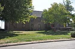
William Kennison Wood House |
|
June 5, 1995
(#95000622) |
Off County Road S27
41°55′15″N 93°24′22″W / 41.920833°N 93.406111°W / 41.920833; -93.406111 (William Kennison Wood House) |
Iowa Center |
|
.jpg)