National Register of Historic Places listings in McKinley County, New Mexico
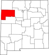
This is a list of the National Register of Historic Places listings in McKinley County, New Mexico.
This is intended to be a complete list of the properties and districts on the National Register of Historic Places in McKinley County, New Mexico, United States. Latitude and longitude coordinates are provided for many National Register properties and districts; these locations may be seen together in a map.[1]
There are 77 properties and districts listed on the National Register in the county, including 2 National Historic Landmarks. All of the places within the county currently or formerly on the National Register are also recorded on the State Register of Cultural Properties.
- This National Park Service list is complete through NPS recent listings posted October 11, 2018.[2]
| Bernalillo – Catron – Chaves – Cibola – Colfax – Curry – De Baca – Doña Ana – Eddy – Grant – Guadalupe – Harding – Hidalgo – Lea – Lincoln – Los Alamos – Luna – McKinley – Mora – Otero – Quay – Rio Arriba – Roosevelt – San Juan – San Miguel – Sandoval – Santa Fe – Sierra – Socorro – Taos – Torrance – Union – Valencia |
Current listings
| [3] | Name on the Register[4] | Image | Date listed[5] | Location | City or town | Description |
|---|---|---|---|---|---|---|
| 1 | Andrews Archeological District |  |
May 17, 1979 (#79003129) |
Address Restricted |
Prewitt | |
| 2 | Archeological Site LA 15278 (Reservoir Site; CM 100) | |
August 2, 1985 (#85001700) |
Address Restricted |
Pueblo Pintado | |
| 3 | Archeological Site LA 45,780 | |
August 2, 1985 (#85001701) |
Address Restricted |
Pueblo Pintado | |
| 4 | Archeological Site LA 45,781 | |
August 2, 1985 (#85001702) |
Address Restricted |
Pueblo Pintado | |
| 5 | Archeological Site LA 45,782 | |
August 2, 1985 (#85001703) |
Address Restricted |
Pueblo Pintado | |
| 6 | Archeological Site LA 45,784 | |
August 2, 1985 (#85001704) |
Address Restricted |
Pueblo Pintado | |
| 7 | Archeological Site LA 45,785 | |
August 2, 1985 (#85001705) |
Address Restricted |
Pueblo Pintado | |
| 8 | Archeological Site LA 45,786 | |
August 2, 1985 (#85001706) |
Address Restricted |
Pueblo Pintado | |
| 9 | Archeological Site LA 45,789 | |
August 2, 1985 (#85001707) |
Address Restricted |
Pueblo Pintado | |
| 10 | Archeological Site LA 50,000 | |
August 2, 1985 (#85001708) |
Address Restricted |
Pueblo Pintado | |
| 11 | Archeological Site LA 50,001 | |
August 2, 1985 (#85001709) |
Address Restricted |
Pueblo Pintado | |
| 12 | Archeological Site LA 50,013 (CM101) | |
August 2, 1985 (#85001710) |
Address Restricted |
Pueblo Pintado | |
| 13 | Archeological Site LA 50,014 (CM 102) | |
August 2, 1985 (#85001711) |
Address Restricted |
Pueblo Pintado | |
| 14 | Archeological Site LA 50,015 (CM 102A) | |
August 2, 1985 (#85001712) |
Address Restricted |
Pueblo Pintado | |
| 15 | Archeological Site LA 50,016 (CM 103) | |
August 2, 1985 (#85001713) |
Address Restricted |
Pueblo Pintado | |
| 16 | Archeological Site LA 50,017 (CM 104) | |
August 2, 1985 (#85001714) |
Address Restricted |
Pueblo Pintado | |
| 17 | Archeological Site LA 50,018 | |
August 2, 1985 (#85001715) |
Address Restricted |
Pueblo Pintado | |
| 18 | Archeological Site LA 50,019 (CM 105) | |
August 2, 1985 (#85001716) |
Address Restricted |
Pueblo Pintado | |
| 19 | Archeological Site LA 50,020 (CM 106) | |
August 2, 1985 (#85001717) |
Address Restricted |
Pueblo Pintado | |
| 20 | Archeological Site LA 50,021 | |
August 2, 1985 (#85001718) |
Address Restricted |
Pueblo Pintado | |
| 21 | Archeological Site LA 50,022 (CM 107) | |
August 2, 1985 (#85001719) |
Address Restricted |
Pueblo Pintado | |
| 22 | Archeological Site LA 50,023 (CM 118) | |
August 2, 1985 (#85001720) |
Address Restricted |
Pueblo Pintado | |
| 23 | Archeological Site LA 50,024 (CM 108) | |
August 2, 1985 (#85001721) |
Address Restricted |
Pueblo Pintado | |
| 24 | Archeological Site LA 50,025 (CM 109) | |
August 2, 1985 (#85001722) |
Address Restricted |
Pueblo Pintado | |
| 25 | Archeological Site LA 50,026 (CM 108) | |
August 2, 1985 (#85001723) |
Address Restricted |
Pueblo Pintado | |
| 26 | Archeological Site LA 50,027 (CM 111) | |
August 2, 1985 (#85001724) |
Address Restricted |
Pueblo Pintado | |
| 27 | Archeological Site LA 50,028 (CM 112) | |
August 2, 1985 (#85001725) |
Address Restricted |
Pueblo Pintado | |
| 28 | Archeological Site LA 50,030 (CM 114) | |
August 2, 1985 (#85001726) |
Address Restricted |
Pueblo Pintado | |
| 29 | Archeological Site LA 50,031 (CM 115) | |
August 2, 1985 (#85001727) |
Address Restricted |
Pueblo Pintado | |
| 30 | Archeological Site LA 50,033 (CM 117) | |
August 2, 1985 (#85001728) |
Address Restricted |
Pueblo Pintado | |
| 31 | Archeological Site LA 50,034 | |
August 2, 1985 (#85001729) |
Address Restricted |
Pueblo Pintado | |
| 32 | Archeological Site LA 50,035 | |
October 9, 1985 (#85003143) |
Address Restricted |
Pueblo Pintado | |
| 33 | Archeological Site LA 50,036 | |
August 2, 1985 (#85001730) |
Address Restricted |
Pueblo Pintado | |
| 34 | Archeological Site LA 50,037 | |
August 2, 1985 (#85001731) |
Address Restricted |
Pueblo Pintado | |
| 35 | Archeological Site LA 50,038 | |
August 2, 1985 (#85001732) |
Address Restricted |
Pueblo Pintado | |
| 36 | Archeological Site LA 50,044 | |
August 2, 1985 (#85001733) |
Address Restricted |
Pueblo Pintado | |
| 37 | Archeological Site LA 50,071 (CM 148) | |
August 2, 1985 (#85001734) |
Address Restricted |
Pueblo Pintado | |
| 38 | Archeological Site LA 50,072 (CM 94) | |
August 2, 1985 (#85001735) |
Address Restricted |
Pueblo Pintado | |
| 39 | Archeological Site LA 50,074 (CM 181) | |
August 2, 1985 (#85001736) |
Address Restricted |
Pueblo Pintado | |
| 40 | Archeological Site LA 50,077 | |
August 2, 1985 (#85001737) |
Address Restricted |
Pueblo Pintado | |
| 41 | Archeological Site LA 50,080 | |
August 2, 1985 (#85001738) |
Address Restricted |
Pueblo Pintado | |
| 42 | Ashcroft-Merrill Historic District | July 27, 1990 (#90001079) |
Junction of Bloomfield and McNeil Sts. 35°08′09″N 108°29′41″W / 35.135833°N 108.494722°W |
Ramah | ||
| 43 | Bee Burrow Archeological District | 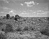 |
December 10, 1984 (#84001296) |
Address Restricted 35°48′45″N 107°57′02″W / 35.81238°N 107.95059°W |
Seven Lakes | |
| 44 | Borrego Pass Trading Post Historic District | March 29, 2012 (#11000475) |
Building 1601, County Road 19 35°39′26″N 108°06′20″W / 35.6572962°N 108.1054688°W |
Borrego Pass | ||
| 45 | Casa de Estrella Archeological Site | |
October 10, 1980 (#80002553) |
Address Restricted |
Crownpoint | |
| 46 | Chaco Culture National Historical Park | 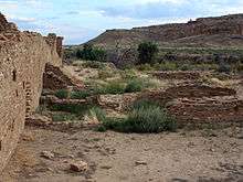 |
October 15, 1966 (#66000895) |
Address Restricted |
Thoreau | |
| 47 | Chief Theater | 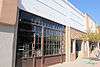 |
May 16, 1988 (#87002223) |
228 W. Coal Ave. 35°31′37″N 108°44′37″W / 35.526944°N 108.743611°W |
Gallup | |
| 48 | C.N. Cotton Warehouse | January 14, 1988 (#87002226) |
101 N. Third St. 35°31′40″N 108°44′41″W / 35.527778°N 108.744722°W |
Gallup | ||
| 49 | Cousins Bros. Trading Post | March 22, 2006 (#06000153) |
768 A-D Cousins Rd. 35°15′04″N 108°53′42″W / 35.251111°N 108.895°W |
Chi Chil Tah | ||
| 50 | Dalton Pass Archeological Site | |
October 10, 1980 (#80002554) |
Address Restricted |
Crownpoint | |
| 51 | Drake Hotel | 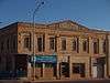 |
January 14, 1988 (#87002218) |
216 E. 66th Ave. 35°31′43″N 108°44′19″W / 35.528611°N 108.738611°W |
Gallup | |
| 52 | El Morro Theater | 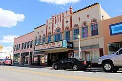 |
May 16, 1988 (#87002221) |
205-209 W. Coal Ave. 35°33′14″N 108°44′28″W / 35.553889°N 108.741111°W |
Gallup | |
| 53 | El Rancho Hotel | 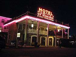 |
January 14, 1988 (#87002222) |
100 E. 66th Ave. 35°31′46″N 108°43′18″W / 35.529444°N 108.721667°W |
Gallup | |
| 54 | Fort Wingate Archeological Site | |
October 10, 1980 (#80002558) |
Address Restricted |
Fort Wingate | |
| 55 | Fort Wingate Historic District | Fort_Wingate%2C_New_Mexico_(shows_the_fort_and_houses)_-_NARA_-_517785.tif.jpg) |
May 26, 1978 (#78003076) |
State Road 400 35°28′01″N 108°32′23″W / 35.466944°N 108.539722°W |
Fort Wingate | |
| 56 | Gallup Commercial Historic District |  |
June 21, 2016 (#16000389) |
Roughly bounded by US 66, W. Coal Ave., S. Puerco Dr. and S. 7th St. 35°31′37″N 108°44′42″W / 35.526864°N 108.744934°W |
Gallup | |
| 57 | Grand Hotel | 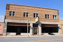 |
May 25, 1988 (#87002217) |
306 W. Coal Ave. 35°31′36″N 108°44′38″W / 35.526667°N 108.743889°W |
Gallup | |
| 58 | Greenlee Archeological Site | |
October 10, 1980 (#80002555) |
Address Restricted |
Crownpoint | |
| 59 | Halona Pueblo | February 10, 1975 (#75002066) |
Zuni 35°04′04″N 108°49′37″W / 35.067778°N 108.826944°W |
Gallup | ||
| 60 | Harvey Hotel | May 25, 1988 (#87002219) |
408 W. Coal Ave. 35°31′35″N 108°44′42″W / 35.526389°N 108.745°W |
Gallup | Distinctively not a hotel of the Fred Harvey Company line. | |
| 61 | Haystack Archeological District | |
October 10, 1980 (#80002556) |
Address Restricted |
Crownpoint | |
| 62 | Roy T. Herman's Garage and Service Station | 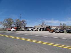 |
November 22, 1993 (#93001212) |
State Road 122, 150 yards west of an exit from Interstate 40 35°23′50″N 108°13′27″W / 35.397222°N 108.224167°W |
Thoreau | |
| 63 | Lebanon Lodge No. 22 | 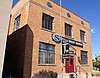 |
February 14, 1989 (#87002225) |
106 W. Aztec 35°31′36″N 108°44′26″W / 35.526667°N 108.740556°W |
Gallup | |
| 64 | Manuelito Complex | |
October 15, 1966 (#66000894) |
Address Restricted |
Manuelito | |
| 65 | McKinley County Courthouse | 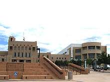 |
February 15, 1989 (#87000879) |
205-209 W. Hill St. 35°31′29″N 108°44′30″W / 35.524722°N 108.741667°W |
Gallup | |
| 66 | Palace Hotel | May 16, 1988 (#87002216) |
236 W. 66th Ave. 35°31′39″N 108°44′36″W / 35.5275°N 108.743333°W |
Gallup | ||
| 67 | Peggy's Pueblo | |
August 16, 1994 (#94000993) |
Address Restricted |
Zuni Pueblo | |
| 68 | Redwood Lodge | 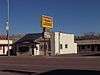 |
February 13, 1998 (#98000051) |
907 E. 66th Ave. 35°31′50″N 108°43′46″W / 35.530556°N 108.729444°W |
Gallup | |
| 69 | Rex Hotel | 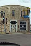 |
January 14, 1988 (#87002215) |
300 W. 66th Ave. 35°31′38″N 108°44′37″W / 35.527222°N 108.743611°W |
Gallup | |
| 70 | Southwestern Range and Sheep Breeding Laboratory Historic District | May 30, 2003 (#03000488) |
Fort Wingate Work Center in the Cibola National Forest 35°27′17″N 108°34′08″W / 35.454722°N 108.568889°W |
Fort Wingate | ||
| 71 | Route 66, State maintained from Iyanbito to Rehobeth | November 19, 1997 (#97001397) |
Former U.S. Route 66 from Iyanbito Interchange at Interstate 40 to State Police Station Rehobeth 35°31′04″N 108°34′46″W / 35.517778°N 108.579444°W |
Rehobeth | ||
| 72 | Route 66, State Maintained from Manuelito to the Arizona Border |  |
November 22, 1993 (#93001209) |
Western side of the Manuelito grade separation southwest to the Arizona border 35°24′40″N 108°59′57″W / 35.411111°N 108.999167°W |
Mentmore | |
| 73 | Upper Kin Klizhin Archeological Site |  |
October 10, 1980 (#80002557) |
Address Restricted |
Crownpoint | |
| 74 | US Post Office | 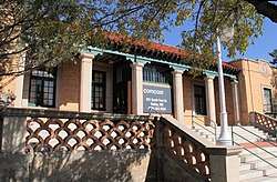 |
May 25, 1988 (#87002228) |
201 S. 1st St. 35°31′39″N 108°44′25″W / 35.5275°N 108.740278°W |
Gallup | |
| 75 | Evon Zartman Vogt Ranch House | February 4, 1993 (#92001819) |
1 mile south of Ramah, 500 feet east of State Road 53 35°07′15″N 108°29′00″W / 35.120833°N 108.483333°W |
Ramah | ||
| 76 | White Cafe |  |
January 14, 1988 (#87002212) |
100 W. 66th Ave. 35°31′41″N 108°44′27″W / 35.528056°N 108.740833°W |
Gallup | |
| 77 | Zuni-Cibola Complex | |
December 2, 1974 (#74002267) |
Address Restricted |
Zuni Pueblo | Extends into Cibola and Valencia counties |
Former listings
Another two properties were once listed, but have since been removed:
| [3] | Name on the Register | Image | Date listed | Date removed | Location | City or town | Summary |
|---|---|---|---|---|---|---|---|
| 1 | C. N. Cotton House | July 10, 1979 (#79003128) | Unknown | 406 W. Aztec Ave. |
Gallup | ||
| 2 | Log Cabin Motel | November 22, 1993 (#93001213) | August 22, 2007 | 1010 West 66 Avenue |
Gallup | Burned in 2004, subsequently demolished. |
See also
| Wikimedia Commons has media related to National Register of Historic Places in McKinley County, New Mexico. |
References
- ↑ The latitude and longitude information provided in this table was derived originally from the National Register Information System, which has been found to be fairly accurate for about 99% of listings. For about 1% of NRIS original coordinates, experience has shown that one or both coordinates are typos or otherwise extremely far off; some corrections may have been made. A more subtle problem causes many locations to be off by up to 150 yards, depending on location in the country: most NRIS coordinates were derived from tracing out latitude and longitudes from USGS topographical quadrant maps created under the North American Datum of 1927, which differs from the current, highly accurate WGS84 GPS system used by most on-line maps. Chicago is about right, but NRIS longitudes in Washington are higher by about 4.5 seconds, and are lower by about 2.0 seconds in Maine. Latitudes differ by about 1.0 second in Florida. Some locations in this table may have been corrected to current GPS standards.
- ↑ "National Register of Historic Places: Weekly List Actions". National Park Service, United States Department of the Interior. Retrieved on October 11, 2018.
- 1 2 Numbers represent an ordering by significant words. Various colorings, defined here, differentiate National Historic Landmarks and historic districts from other NRHP buildings, structures, sites or objects.
- ↑ National Park Service (2010-07-09). "National Register Information System". National Register of Historic Places. National Park Service.
- ↑ The eight-digit number below each date is the number assigned to each location in the National Register Information System database, which can be viewed by clicking the number.
| Topics | |
|---|---|
| Lists by states |
|
| Lists by insular areas | |
| Lists by associated states | |
| Other areas | |
| |
Municipalities and communities of McKinley County, New Mexico, United States | ||
|---|---|---|
| City | | |
| CDPs | ||
| Unincorporated communities | ||
| Indian reservation | ||
| Footnotes | ‡This populated place also has portions in an adjacent county or counties | |