Fort Wingate
| Fort Wingate | |
|---|---|
| McKinley County, near Gallup, New Mexico | |
Fort_Wingate%2C_New_Mexico_(shows_the_fort_and_houses)_-_NARA_-_517785.tif.jpg) Fort Wingate in the 1870s | |
| Coordinates | 35°06′45″N 107°52′58″W / 35.112466°N 107.882652°W |
| Site information | |
| Controlled by |
|
| Condition | ammunition depot, storage facility |
| Site history | |
| Built | 1862 |
| Built by |
|
| In use | 1862 - 1993 |
| Battles/wars |
Apache Wars Navajo Wars |
| Garrison information | |
| Past commanders |
Kit Carson William Redwood Price |
| Garrison |
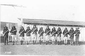
Navajo Scouts Apache Scouts 4th Cavalry 8th Cavalry 9th Cavalry and 13th Infantry 15th Infantry |
| Occupants | United States Army |
|
Fort Wingate Historic District | |
  | |
| Location | NM 400, Fort Wingate, New Mexico |
|---|---|
| Area | 27 acres (11 ha) |
| Built | 1868 |
| NRHP reference # | 78003076[1] |
| NMSRCP # | 403 |
| Significant dates | |
| Added to NRHP | May 26, 1978 |
| Designated NMSRCP | August 22, 1975 |
Fort Wingate is near Gallup, New Mexico. There were two other locations in New Mexico which were called Fort Wingate: Seboyeta, New Mexico (1849-1862) and San Rafael, New Mexico (1862-1868).[2] The most recent Fort Wingate (1868-1993) was established at the former site of Fort Lyon, on Navajo territory, initially to control and "protect" the large Navajo tribe to its north. The Fort at San Rafael was the staging point for the Navajo deportation known as the Navajo's Long Walk. From 1870 onward the garrison near Gallup was concerned with Apaches to the south, and through 1890 hundreds of Navajo Scouts were enlisted at the fort.
Fort Wingate supplied 100 tons of Composition B high explosives to the Manhattan Project for use in the first Trinity test and became an ammunition depot "Fort Wingate Depot Activity" from World War II until BRAC closed it in 1993. Environmental cleanup of UXO, perchlorate and lead as well as land transfer continue to the present day.
History
- Ojo del Oso, in Spanish (meaning "Bear Springs"), was a Navajo place visited for good grazing and water.
19th century
- 1849 A hay camp was set up near Seboyeta, New Mexico and was called Fort Wingate.[3] It was named for Major Benjamin Wingate, 5th U.S. Infantry, who died on 1 June 1862 from wounds he received during the Battle of Valverde.[4]
- 1860 Fort Fauntleroy was established at Bear Springs (Ojo del Oso) as an outpost of Fort Defiance. General Thomas T. Fauntleroy named the fort for himself.[3]
- 1861 Fort Fauntleroy was renamed Fort Lyon for Brig. Gen. Nathaniel Lyon, a Unionist, when Fauntleroy left New Mexico to join the Confederacy. Fort Lyon was closed on 10 September 1861 at the start of the Civil War.[3]
- 1862 Fort Wingate was moved near a large spring at San Rafael, New Mexico, also known as "Bikyaya" or "El Gallo"(the rooster).[4][3] It was designed to house four companies of troops.
- 1864 Edward Canby ordered Colonel Kit Carson to bring four companies of the First New Mexico Volunteers to the fort to "control" the Navajo.
- 1864-1866 It was the staging point for the Navajo deportation known as the Long Walk of the Navajo.
- 1865 the New Mexico Military District had 3,089 troops, 135 of them at Fort Wingate.
- 1868 Fort Wingate was moved back to the former site of Fort Lyon at Ojo del Oso.[5]
1868 Navajo people returning from Bosque Redondo were temporarily settled at the Oso Del Ojo Fort Wingate before spreading out into the newly established Navajo Reservation.
- 1873 - 1886 The fort´s troops participated in Apache Wars with troops and recruited Navajo Scouts.
- 1878 Fort Wingate had 137 troops.
- 1868-1895 Fort Wingate troops often settled disagreements between Navajo and "citizens" in New Mexico.
- 1891 Fort Wingate troops assisted Arizona units against angry Hopis.
20th century
- 1907 Two troops of the 5th Cavalry went from Fort Wingate to the Four Corners area after some armed Navajo. This was the last armed expedition the US Government made against the Navajo. One Navajo was killed and the rest escaped.
- 1911 A Ft. Wingate company of cavalry went to Chaco Canyon and camped there several days to quell a possible uprising by Navajo.
- 1914 during the Mexican Civil War over 2,000 Mexican soldiers and their families took refuge at the fort.
- 1918 Fort Wingate focus turned from Navajo to World War I.
- 1940 Fort Wingate became an ammunition depot from World War II until 1993.
- 1944 Fort Wingate supplied 100 tons of Composition B high explosives to the Manhattan Project for use in the first Trinity test
- 1950 Bureau of Indian Affairs was given part of the polluted land for an Indian boarding school
- 1960–67Redstone (rocket) and Pershing 1 missiles were tested among others at Wingate.
- 1971 DoD Placed Fort Wingate on reserve and re-designated as "Fort Wingate Depot Activity" or FWDA.[6]
- In 1988, the Base Realignment and Closure round 1 decided to close the Fort.
- Environmental restoration activities at FWDA began in 1989.[7]:11
- In January 1993, the Base Realignment and Closure Act (BRAC) closed the post.
21st century
- Though the fort´s mission ended, the Missile Defense Agency (MDA) continues to use 6,465-acres for launching target rockets to White Sands Missile Range (WSMR).[7]:6
- In December 2005, the New Mexico Environment Department (NMED) issued the Army a Resource Conservation and Recovery Act (RCRA) Permit[7]:6
- As of 2016, FWDA spread across 21,131 acres, occupyied 15,280 acres of land and a BRAC acreage of 14,666.[7]:6
- Environmental cleanup and land transfer to the surrounding community continues to the present, through at least 2022. 5,854 acres have already been transferred to the Department of Interior.[7]:6Explosives, perchlorates and nitrates are the primary contaminant in the northern groundwater plumes which have not migrated off-post, all other sites consist of relatively minor soil or building contamination without groundwater issues but with explosives, SVOCs, and metals like lead.[7]:11
Famous U.S. military figures
Several famous military commanders cycled through Fort Wingate's history.
- Lt. Charles B. Gatewood (1853 –1896) led many patrols out of Wingate and later convinced Geronimo to surrender
- 1881-85 General Douglas MacArthur lived at the fort as an infant, with his father, a Captain in command of Company K, 13th US Infantry.
- 1889-90 General John J. (Black Jack) Pershing served as Lieutenant at the fort.
The above extracted from AMCIS-102 dated 1 July 1970, Ft Wingate
See also

References
- ↑ National Park Service (2010-07-09). "National Register Information System". National Register of Historic Places. National Park Service.
- ↑ San Rafael is at 35°06′45″N 107°52′58″W / 35.112466°N 107.882652°W.
- 1 2 3 4 Fort Wingate @NewMexicoHistory.org
- 1 2 Fraizer, Robert Walter (1965). Forts of the West. Norman: University of Oklahoma Press. ISBN 0-8061-1250-6.
- ↑ James H. Defouri, Historical Sketch of the Catholic Church in New Mexico (1887) p.81
- ↑ About FWDA, n.d. retrieved 17 June 2017
- 1 2 3 4 5 6 FY2016 Fort Wingate Depot Activity Base Realignment & Closure Installation Action Plan 29 November 2016, 41 pp
External links
- http://www.astronautix.com/sites/forngate.htm Includes chronology and launch log.
- http://www.globalsecurity.org/military/facility/fort-wingate.htm Includes comprehensive history on Fort Wingate.
- http://www.ftwingate.org/ Website dedicated to the cleanup
- The History of Fort Wingate, by Harold James, 18th NM Genealogical Field Conference
- Coordinates: 35°28′04″N 108°32′26″W / 35.46778°N 108.54056°W
| Topics | |
|---|---|
| Lists by states |
|
| Lists by insular areas | |
| Lists by associated states | |
| Other areas | |
| |