Mykolaivka, Donetsk Oblast
| Mykolaivka Миколаївка | |||
|---|---|---|---|
| City | |||
.JPG) Soviet war memorial in Mykolaivka | |||
| |||
| Oblast | Donetsk | ||
| Population (2013) | |||
| • Total | 15,684 | ||
| Website | http://mykolaivka-rada.gov.ua/ | ||
Mykolaivka (Ukrainian: Миколаївка, Russian: Николаевка) is a city of district significance and administrative centre of Mykolaivka City United Territorial Community[1] in Sloviansk Raion, Donetsk Oblast (province) of Ukraine to the south of the railway station Elektrychna[2]. Population: 15,684 (2013 est.)[3].
On 4 July 2014, Ukrainian forces reportedly secured the city from pro-Russian separatists.[4][5][6] The hospital began renovations in 2015, having been damaged in the fighting, with pro-Russian militants positioned around the building and on its roof.[7]. In 2016, the Verkhovna Rada appropriated the status of the city of district significance, withdrew it from the composition of the Sloviansk municipality and included it in the Sloviansk Raion[8].
.
Gallery
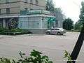 Bank department in Mykolaivka
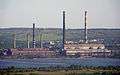 Sloviansk thermal power plant
References
- ↑ "Mykolaivs'ka mis'ka hromada" Миколаївська міська громада [Mykolaivka City Community]. Portal of United Territorial Communities of Ukraine (in Ukrainian). Retrieved July 12, 2018.
- ↑ Маклаївка. Ministry for Regional Development, Building and Housing of Ukraine, Ukraine State Service of Geodesy, Cartography and Cadastre. Geoportal of administrative-territorial system of Ukraine (Report) (in English and Ukrainian). Retrieved 2018-07-12.
- ↑ "Чисельність наявного населення України (Actual population of Ukraine)" (in Ukrainian). State Statistics Service of Ukraine. Retrieved 21 January 2015.
- ↑ Balmforth, Richard; Grove, Thomas. "UPDATE 3-Ukraine's president seeks new crisis talks at weekend, fighting rages". www.reuters.com. Reuters. Retrieved 4 July 2014.
- ↑ Government forces continue to free towns and capture gunmen's weapons and equipment in eastern Ukraine - NSDC, Interfax-Ukraine (3 July 2014)
- ↑ Українські військові взяли під контроль Миколаївку - Аваков. tsn.ua (in Ukrainian). Новости Украины на 1+1 - ТСН.ua. 4 July 2014. Retrieved 5 July 2014.
- ↑ Liubchenkova, Natalia (14 March 2016). "Resilience and rebuilding – tales from a war-torn Ukraine hospital". euronews.com.
- ↑ "On changes in the administrative-territorial structure of the Donetsk Oblast, change and establishment of boundaries of the city of Sloviansk and Sloviansk Raion of Donetsk Oblast". Verkhovna Rada (in Ukrainian). 2016-09-08. Retrieved 2018-07-12.
| Raions | |||||
|---|---|---|---|---|---|
| Cities |
| ||||
| |||||