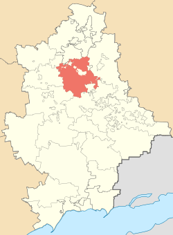
Kostiantynivka Raion
| Kostiantynivka Raion Костянтинівський район | |||
|---|---|---|---|
| Raion | |||
| |||
 | |||
| Coordinates: 48°31′36″N 37°42′15″E / 48.52667°N 37.70417°ECoordinates: 48°31′36″N 37°42′15″E / 48.52667°N 37.70417°E | |||
| Country |
| ||
| Region | Donetsk Oblast | ||
| Established | 7 March 1923[1] | ||
| Admin. center | Kostiantynivka | ||
| Subdivisions |
List
| ||
| Government | |||
| • Governor | Serhiy Ivakhnin[2] | ||
| Area | |||
| • Total | 1,172 km2 (453 sq mi) | ||
| Elevation[3] | 86 m (282 ft) | ||
| Population | |||
| • Total | 19,160 | ||
| • Density | 16/km2 (42/sq mi) | ||
| Time zone | UTC+2 (EET) | ||
| • Summer (DST) | UTC+3 (EEST) | ||
| Postal index | 85100-85185 | ||
| Area code | +380-6272 | ||
| Website | www.donoda.gov.ua | ||

Kostiantynivka Raion (Ukrainian: Костянтинівський район; Russian: Константиновский район) is one of the 18 administrative raions (a district) of Donetsk Oblast in eastern Ukraine. It covers approximately 4.4 percent of the oblast's total area.[4] Population: 19,160 (2013 est.)[5]; 21,132 (2001 Ukrainian Census).[1]
The district was created on 7 March 1923 as part of the Ukrainian Soviet Socialist Republic.[1] Its administrative center is the city of Kostiantynivka, although the city itself is not administratively part of the Kostiantynivka Raion and is incorporated as a city of oblast significance.
Administrative divisions
The Kostiantynivka Raion is divided in a way that follows the general administrative scheme in Ukraine. Local government is also organized along a similar scheme nationwide. Consequently, raions are subdivided into councils, which are the prime level of administrative division in the country.
Each of the raion's urban localities administer their own councils, often containing a few other villages within its jurisdiction. However, only a handful of rural localities are organized into councils, which also may contain a few villages within its jurisdiction.
Accordingly, the Kostiantynivka Raion is divided into:[1]
- 20 village councils
Overall, the raion has a total of 60 populated localities, consisting of 49 villages, and 11 rural settlements.[1]
Demographics
As of the 2001 Ukrainian census:[6]
- Ethnicity
- Ukrainians: 77.3%
- Russians: 19.9%
- Belarusians: 0.9%
References
- 1 2 3 4 5 "Kostiantynivka Raion, Donetsk Oblast". Regions of Ukraine and their Structure (in Ukrainian). Verkhovna Rada of Ukraine. Retrieved 7 March 2012.
- ↑ "Leaders of the Raion State Administration". Kostiantynivka Raion State Administration (in Ukrainian). Donetsk Oblast State Administration. Retrieved 7 March 2012.
- ↑ "Kostiantynivka (Donetsk Oblast, Kostiantynivka Raion)". weather.in.ua (in Ukrainian). Retrieved 7 March 2012.
- ↑ "Kostiantynivka Raion". Informational Portal of Donechchyna (in Ukrainian). Retrieved 7 March 2012.
- ↑ "Чисельність наявного населення України (Actual population of Ukraine)" (in Ukrainian). State Statistics Service of Ukraine. Retrieved 21 January 2015.
- ↑ Національний склад та рідна мова населення Донецької області. Розподіл постійного населення за найбільш численними національностями та рідною мовою по міськрадах та районах (in Ukrainian), archived from the original on 27 November 2012
External links

- "News". Kostiantynivka Raion State Administration (in Ukrainian). Donetsk Oblast State Administration. Archived from the original on 30 December 2011. Retrieved 7 March 2012.
| Villages |
| |
|---|---|---|
| Rural settlements |
| |
| Raions | |||||
|---|---|---|---|---|---|
| Cities |
| ||||
| |||||