Dobropillia Raion
| Dobropils'kyi Raion Добропільський район | |||
|---|---|---|---|
| Raion | |||
| |||
 | |||
| Coordinates: 48°28′59.8656″N 37°0′42.2886″E / 48.483296000°N 37.011746833°ECoordinates: 48°28′59.8656″N 37°0′42.2886″E / 48.483296000°N 37.011746833°E | |||
| Country |
| ||
| Region |
Donetsk Oblast (de Jure) Dnipropetrovsk Oblast (de Facto) | ||
| Established | N/A | ||
| Admin. center | Dobropillia | ||
| Subdivisions |
List
| ||
| Government | |||
| • Governor | N/A | ||
| Area | |||
| • Total | 949 km2 (366 sq mi) | ||
| Population | |||
| • Total | 16,622 | ||
| • Density | 18/km2 (45/sq mi) | ||
| Time zone | UTC+2 (EET) | ||
| • Summer (DST) | UTC+3 (EEST) | ||
| Postal index | 873-XX | ||
| Area code | 380 | ||
| Website | Verkhovna Rada website | ||
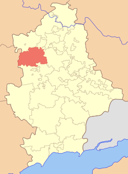
The Dobropillia Raion (Ukrainian: Добропільський район, translit.: Dobropil's'kyi raion; Russian: Добропо́льский район, translit.: Dobropol'skiy raion) is a raion (district) within the southwestern part of Donetsk Oblast in eastern Ukraine. Its administrative center is Dobropillia, which is incorporated separately as the town of oblast significance and does not belong to the raion. Its area is 949 km2 (366 sq mi), and its population is approximately 15,695 (2017 est.)[1].
Within the Dobropillia Raion there is: one urban-type settlement (Svyatohorivka - 2,100 inhabitants), 9 selsovets, and 66 settlements. Also included within the raion are: 17 kolhozy, and 3 sovhozy, 4 industrial organizations, 4 construction organizations, 2 railroad stations, 44 Meduchredzheniy, and 47 libraries.
An architectural monument in the raion is a palace (1887-1914-selo Zelyenoe).
In May 2014, due to the deteriorating situation in the Donetsk Oblast, the Raion requested a referendum pertaining to the absorption of Dobropillia Raion into the Dnipropetrovsk Oblast, where the situation was calm and stable. Dnipropetrovsk Governor Ihor Kolomoisky announced that the oblast would be willing to do so assuming that is what the citizens want.[2]
Settlements
- Vodianske
- Volodymyrivka
- Virovka
- Hannivka
- Zolotyi Kolodiaz
- Krasnoiarske
- Kryvorizhia
- Novyi Donbas
- Novovodiane
- Novodonetske
- Novotoretske
- Novotroitske
- Novofedorivka
- Oktiabrske
- Rozy Liuksemburh
- Sviatohorivka
- Svitle
- Shevchenko
- Shylivka
Demographics
As of the 2001 Ukrainian census:[3]
- Ethnicity
- Ukrainians: 89.4%
- Russians: 8.9%
See also
References
- ↑ "Чисельність наявного населення України (Actual population of Ukraine)" (in Ukrainian). State Statistics Service of Ukraine. Retrieved 26 August 2017.
- ↑ http://www.kyivpost.com/content/ukraine/dnipropetrovsk-region-willing-to-take-over-parts-of-donetsk-luhansk-regions-347515.html
- ↑ Національний склад та рідна мова населення Донецької області. Розподіл постійного населення за найбільш численними національностями та рідною мовою по міськрадах та районах (in Ukrainian), archived from the original on 2012-11-27
External links
- (in Ukrainian) Verkhovna Rada website - Administrative divisions of the Dobropillia Raion
| Raions | |||||
|---|---|---|---|---|---|
| Cities |
| ||||
| |||||